Through the Depths
From the
Third Rock From the Sun
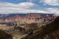
![Tanner Trail]() Escalante Route
Escalante Route
At these ages, I found out that there is an entirely different world under the water, beneath the rim or on top of the mountain. That there is so much more to see if you learn how to see it off season; if you don't need a Mickey D's or a Holiday Inn to see it………….
…………… This is my story, or really, the story of any dopamine affected positive T-types destined to wonder this planet. Not so much a story told with text but many times a thousand words are told just the same. A little story told in digital doodle and photography, about travel and high adventure on this the Third Rock From the Sun”
Robert (IGO) Ellis Jr.
This is a much generalized report about walking the Trails and Routes under the South Rim Drive of the Grand Canyon of the Colorado River. These reports are really just a recreational endeavor not meant to be definitive in anyway yet they serve as well or better as Route Descriptions as they do Trip Reports. I've only voiced navigational, geological and survivability tips as I think of them and that information may be pertinent to all sections of the Canyon. For that reason, these reports are best read in their entirety starting from routes east and walking west. This part of my walks from Lava Falls in the East to Sapphire Canyon in the west pertains to the Escalante Route.
This loop encompasses the Tanner Trail, the Escalante Route, the beginning of the Eastern Tonto Shelf and the Grandview Trail and is 31.9 miles in length. This report is the first of 6 such reports in a continuing story covering approximately 134 foot miles of walking in the backcountry of the Grand Canyon. It is probably representative of most seasoned/regular Grand Canyon Backpackers experiences here. Radical Canyoneers will like the pretty pictures but won't find much else here that they can use. Beginning hikers will need to start much simpler than these and stay away from the majority of these walks.
Part 2 of 6 will continue with a relitively short
Horseshoe Mesa Combinations tail.
The First Time We Met
The first time I peered over the rim of the Grand Canyon the tendons in my jaw went taught. I stood with my mouth agape and a stone formed in my throat. I teetered on weakened knees; I was awe struck. I could not find the words.
It was calm that day but I dared not stand another inch closer to the rim. At 5 feet away it felt like the spirit would vacuum me in. My life changed course at that moment. Nothing would every be the same.
It was before they re-worked the park entrance road from Flagstaff and I was driving an ancient U-Haul truck with all my parents’ worldly goods in it. The old truck surged and bucked as it took everything that truck would do in first gear to make the grade. When I finally got the household wares to Kingman a day later we all but had to torch the back door open as everything inside the van had settled hard against it. It was an 8 ton truck on a 2 ton road. I didn’t care; I was going to see this canyon. Four months later I left Dallas to be as close to “The Canyon” as I could without starving to death. (find a job!) That was almost 30 years ago. I’ve spent months under the rim sense but it didn’t start out that easy……
From
Gearing Up for Hiking Down
“They kept bugging me to go but I only thought they were crazy. One day while un-employed I ran out of excuses so I went. My first backpack. Blue Jeans. Flat bottom work boots from K-Mart. A Navy seamans duffle bag. Grandview to Hance Creek. The next day?! Riga mortise; pure and simple. 'I would never do this again’ but something about this place. In a month, I was back again…….”
Usually I don't do trip reports; sometimes it feels like I'm giving something sacred away but other times I want to stand on Zorister Temple and shout out what I feel in my heart. Only a hand full of people are allowed below the rim at any one time, especially in the more remote places. I think I won't have to give up to many secrets. I will show you some pictures and try to tell you what it is like to walk for a week below the rim of the Grand Canyon. I hope you have some of the fun here that I have when I walk in the Canyon.
My Years of the Escalante
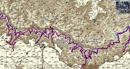
![South Rim Record of Travel]() Others have walked harder and into more remote areas but I'm proud of and privilaged to have walked what I've walked. This image represents my Grand Canyon traverses from Lava Falls to Sapphire Canyon.
Others have walked harder and into more remote areas but I'm proud of and privilaged to have walked what I've walked. This image represents my Grand Canyon traverses from Lava Falls to Sapphire Canyon. over the years to decide what area of the Grand Canyon is my favorite. I've marched from Lava Falls to Sapphire Canyon trying to make that determination. Ultimately I had to decide it was a fruitless endeavor. All of "The Canyon" is the best canyon there is.
I had walked many hikes. Once I walked for 23 days having set up caches to resupply prior to my trip. One year I spent 100 nights below the rim. One day I thought it would be great to do something new......to do nothing. I sat up a tri-pod for my camera on Tanner beach and promised myself I wouldn't move outside of a functional circle I had imagined circling my tripod. A circle maybe 10 feet across. I never left the circle with my camera that day.
I shot sunrise pictures. I shot sunset pictures. I shot across the river in front of me and I shot the rim behind me. I took pictures of the rapids 75 yards out and I took pictures of flowers no more than a quarter inch in diameter. When back in The World I examined the best of these images I had to be pleased to know that the pictures I took could have been representative of dozens of the most beautiful places in the world yet all were taken within a 10 foot sphere.
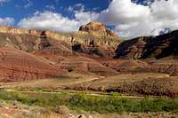
Tanner Trail
![Into the Red Wall]() Tanner Trail
Tanner Trail.
![Tanner Trail and its Profile]() Profile of the Tanner Trail
Profile of the Tanner Trail
Standing at the trailhead at
Lipon Point I can check general weather conditions for 100 miles in every direction. The amount of snow on Humphreys Peak in Flagstaff 60 miles away tells me if spring is near or if there is some chance of more winter weather in the near future. Looking across to the Palisades I can tell what kind of barometric pleasure we have by the degree of visibility. This and checking the height or existence of cloud formations on the North Rim can be a pretty good gauge for predicting weather for the next 3 or 4 days also.
Law of averages for the Canyon Country of the Desert South West dictates that March/April and October are the best times of the year to backpack the canyons here. I spend at least a week below the rim every April and October. A little trick I use to extend the useful day in months when nights are long is to plan my backpacks during weeks of the full moon. There is nothing greater than watching the sky almost go to black only to have a full moon rise over Wantons Throne just as last purple chases the sun into the ground over the Palisades.
The Tanner tends to run along the ridge of Cardenas rather than sticking to side canyon bottoms like most Rim to River trails do so a moon that rises in the west won’t lend itself to navigation as well as it does on the relatively flat and open Tonto Trail canyon traverse far below. This is a good reason to make sure you are hiking the Tanner in cooler months as well.
In the upper reaches of the Tanner it is said that some route finding is critical but my experience tells be the way is narrow and no matter how many trail splits there are, sooner or later they all come back together and unite in a single path for the rest of the journey to the River.
It’s a long walk to the River on the Tanner and some such as myself prefer, for two reasons, to make it a two day journey. One reason formerly stated; it’s a long hard march to the river so make sure you have two days hydration with you. The second and greater reason for taking two days down is the
camp on top of the Red Wall out from Cardenas Butte. It’s just about the most magnificent view on the planet, sunrise and sunset.
Warning! It takes 2+ gallons of water to get to the Colorado if you intent to camp up on the Red Wall overnight. Do not skimp on water.
Once at Tanner Beach head downstream, making sure you do not traipse on the dunes, to find your best camp spots. Immediately thereafter, fill you collapsible bucket with water as you’re likely to want to let your river water settle out a bit before filtering. At the West end of the beach are still pools to jump in but beware, the water is 54 degrees and a shock jumping into. Do not jump in water that is visibly stirring as you don’t want to get caught in rip currents and take unplanned surf down the river. NOT a good river for that! Keep your kitchen away from the river. River levels are dictated by gate openings on the Glenn Canyon Dam and the close proximity to the Dam can change water levels very quickly. I’ve had one cook set eaten by the river for this very same reason.
Some will layover at Tanner for a day to take a challenging day hike out to the Little Colorado River. I have little experience with the Little C and that was many years ago but I feel safe in telling you that a day hike out to Lava Rapids on the Beamer trail is easy and refreshing as it rarely lives the rivers side, gains or losses little elevation and offers some of the only views up the Colorado River as it makes its only North South traverse before turning west at your Tanner Beach camp area.
Escalante Route - Tanner to Cardenas and some useful Geology talk
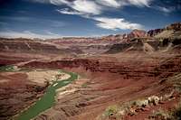
![Cardenas Creek at Unkar]() Flats from Cardenas Creek
Flats from Cardenas Creek
I've paid the dues for the careening walk from the Rim to the River. Though the Tanner is more involved than other rim to river trails it is still visited with some moderate regularity. It’s when we turn East and start heading down River that things get really quite. I think it’s the inevitable sensation that when you step into the Escalante Route it becomes you and only you and your lifeline on your back, your wits along with an understanding that the walking ahead has certain challenges that most Rim to River trails just don’t have and that encounters with other people may be days apart. This is what keeps the traffic low on the Escalante and rightfully so and this is what I find irresistible about the Escalante Route. Still, 25 years ago I could walk all the way to Hance Creek without ever seeing a sole but today one is likely to come across several other parties in the days it takes to cross this area.
This first section is called Furnace Flats. Actually it’s across the River that originally held that designation but most refer to the entire area between Tanner Rapids and Unkar Delta Furnace Flats these days and there is a reason. Some very elementary geology lessons here:
![Escalante Route Profile]() Escalante Route Profile
Escalante Route Profile
The upper reaches of the Grand Canyon are softer sandstone. They erode more quickly than the metamorphosised Schist of MOST of the Grand Canyons lower reaches. The softer sandstone is easily undercut and erodes back away from the center of the canyon in relatively short time on the evolutionary clock. Lower though, under a great deal of pleasure, heat and time the Vishnu Schist, easily recognized up close by its decidedly sturdier granite like hardness and composition rather than the soft volcanic or crumbly sandstones of the rest of the canyon. The schist is much more resistant to erosion than the sandstone so the river and its tributaries tend only to cut straight down through it and at a much slower pace leaving behind a much steeper, narrower inner canyon within the canyon. In fact, in a million years or so the Grand Canyon may erode so much so that the two rims are far enough apart that we don’t recognize the upper canyon as a canyon at all anymore and the only discernable canyon will be the slowly growing inner gorge of the Vishnu Schist.
Anyway I still have a point to make. Some great time ago, long before the deposits of sandstone were laid down on top of the schist by advancing and retreating shallow seas, there was a great seismic event over time as the Pacific tectonic plate slides under the Continental shelf causing great tilt block lifting of the Vishnu Schist. This abnormality can be seen just down river from the Flats as witnessed by the darker shelf of the inner gorge plows into the river at a 20 degree slope. As one moves further down river it is highly evident the lip or the inner gorge rapidly develops into a deep, narrow canyon within the Canyon as it ramps itself out of the river bottom.
Again, back to why Furnace Flats is Furnace Flats. Before the schist rises to become the shade pool it often is in its depths, the sandstone reaches all the way to the river and that only happens in the eastern end of the canyon therefore exists in this area a wide and open bottom not common in the rest of the Canyon. Here the sun bares down on the open bowl or the flats. In summer months, this can be the hottest part of the Grand Canyon.
I’m a very slow hiker. I play with caterpillars and rocks all day and photograph every humming bird so I usually only make it from Tanner Beach to Cardenas on the other side of the flats before putting down a camp. The best level ground is on the West side of the Cardenas Creek drainage at the Tamarisk at rivers edge. A nice photograph of a
Camp at Cardenas Creek can be found here. The route between Tanner and Cardenas is straight forward, just follow the bank or watch for cairns for the short distances you are taken away from the river for obstacles. For some, it might be a very good idea to start the next day’s hike from Cardenas as route finding and often treacherous exposed skree walking can be difficult between here and the next water at Escalante Creek.
Escalante Route - Cardenas Creek to Escalante Creek
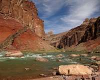
![Unkar Overlook again]() East from the point between Cardenas and Escalante Creek
East from the point between Cardenas and Escalante Creek
The departure from Cardenas and the Flats is immediate and abrupt. In moments I am approaching Unkar Overlook and the visual of the river snaking its way through the Canyon opens up all around me. It’s hard to take pictures in the direction I just came because the sunrise is directly over the river but upon reaching Unkar Overlook and the knoll above it I am afforded the first real glimpses the way west ahead of me. “Gulp!” There is the “Skree slope just west of the Un-named Drainage” as the area is affectionately referred to.
Immediately leaving the head of Un-named Drainage the foot path becomes no wider than the foot and is crumbling and ascends at a great rate. The footing remains treacherous all the way across the traverse of the skree slope and a sharp pointed walking staff is highly welcomed here as an additional plant. At least there is a tread width path of sorts these days as 20 years ago there was nothing but ball bearings to hell. The reward? The view from the point out over the river between Un-named and Escalante Creek can bring stupefying emotions to surface it is so incredibly breathtaking. But we’re not done with the fun stuff yet.
There must be 5 different published descriptions of how to skirt the multiple drainages and pore-offs to finally get to the Escalante Creek bottom at a place that is navigatible for the rest of the short way to the river. I won’t even try. The best luck I ever had before I finally recorded the way on GPS was by reading the NPS description one deciphered word at a time. In the 80’s I spent one additional night in route on several different visits just circling and backtracking trying to pick my way to the river. Route finding skills are absolutely essential and I suggest bringing the extra water just in case you don’t find your way the first day. The written description can be obtained from the Grand Canyon Backcountry Rangers Office.
There is a huge sandy beach at Escalante Creek but if you camp on it by yourself and a larger party comes along they have little recourse but to pitch right beside you. I prefer the sandy point right out at the very edge of the river. It is 3 feet from the water and 30 feet from the rapids and has just enough room for a small camp and there are rocks there that when you sit with your back against them you came wiggle your butt into the sand in such a way as to create the perfect recliner chair with the perfect view of the river. This is a special place to watch rafter parties as they go by as they are so close you can communicate hellos with them above the noise of the rapids.
There is another sandy beach just a couple hundred yards downstream at the mouth of
75 Mile Canyon and large rafting parties use this beach regularly. One time years ago I and a new girlfriend decided we were going to
make happy on my bed roll in the middle of the day when nobody else was around for miles. The aerobics of the event made the vinyl bedroll slide across the tent floor and half way out of the tent before we were through. Upon satisfactorily completing of our happy task we discovered the formerly vacant beach at 75 Mile canyon was covered with dozens of keyaks and several rafts who all just moments before had to pass within 40 feet of us completely un-noticed. I bet those folks had a story to tell when they got back to Detroit or wherever.
An Excerpt from a Hikers Journal
“I look across the river, maybe a hundred yards wide at this point. Very swift but not quit rapids here. I laugh at the irony of this comparison. I can probably toss a stone over to the opposite bank but to stand on it I’d have to hike two hard days out then drive for a day then hike for another 2 or 3 days. It would take a week of hard work and careful planning to pick up the stone I just tossed across the river. I love this place.” Written by moonlight
Cardenas Creek - 1987
Escalante Route - Escalante Creek to Hance Rapids
![Escalante Route]() Escalante Route
Escalante Route
It all depends on how one feels about exposure, dangerous skree and simple free climbs as to how much time you want to travel this next leg. The distance is really very short and the way is easier than it used to be but you are in the air most of this stretch. I’m a slow hiker and I solo so I take my time across here.
Leaving Escalante Creek for the
Papago Wall is to step up on the start of the ramp we mentioned earlier. This is not the true Tonto Shelf yet but stuff laying on top of it. In very short distance we come upon the lip over the river the mouth of
75 Mile Canyon. This very spot reminds me of a story.
In April 1993 I was camped at Tanner Beach when at 3AM a 4.5 Richtor Scale earth quake started with its epicenter 25 miles south of the rim. The quake was small as quakes go but 25 miles away and I can hear huge boulders crashing into the river in complete blackness. My tent was open and the earth moved back and forth but my sleeping bag stayed still as my bedroll slid back and forth underneath me. A day or two later I came to this spot at 75 Mile Canyon and found a spider web of cracks spreading out on the crust in every direction. I was horrified. I couldn’t tell if the earth was going to fall out from under me as it looked like the lip of 75 Mile Canyon was going to cave-in to fill the gorge below at any minute. Obviously it was damage from the earthquake days before. I had no choice. I took a deep breath and ran across the little cracks as fast as I could for about 100 yards. It seemed like they would never come to an end but finally I stopped seeing them. I was also in a very big hurry while heading to the beach in 75 Mile once I got in it; looking up and over my shoulder for a cave-in as I went. I met a rafting party who had also experienced the quake a little further up river. I hitched a ride with them being terrified of the Papago Wall and moreso, the
land-slide (you've got to open this picture all the way and look at this booger) to the river after it. Today it is obvious that the cracks in the earth were probably only inches deep and only in the crust laying on top of rock just under the surface of the crust but at the time I simply couldn’t know that and I was in the middle of nowhere and by myself. Two days later I was in my sleeping bag laying on the ground on Horseshoe Mesa. Another quake came. This time I distinctly heard the low rumble of 10,000 freight trains roaring straight down the canyon running west to east. It was so definite that I could predict when the wave-form would strike and I braced myself on the ground with my hands for it. The wave hit and I couldn’t hold my pose. Again my sleeping bag slid violently back and forth across my sleeping pad. If it were not for the two slippery surfaces I would have been scuffed up pretty good from being pitched around. As it were, I really didn’t move much after I picked my hands up off the ground. As fast as it came, it went and the ground stopped shaking under me but I could still hear the 10,000 trains heading away from me up river towards the East until the sound just went away. To this day I get excited just thinking about it. At that time I considered myself extremely fortunate. Not that I survived the ordeal but rather that I was blessed to have experienced it. It is to this day still the greatest eco-experience I’ve very had and I cherish the memory of it. It was even better than being hit in the boots by a rattlesnake or having your hair stand on end from a to near by lightning strike. “Hey! Do that again!”
OK. Back to 75 Mile Canyon.
If you look closely and recall everything you’ve read about the
Papago Wall, you can step to the edge at the top of the outset of the mouth of 75 Mile Canyon and see the Papago Wall and the trail on top moving away toward Red Canyon and Hance Rapids. Don’t try; you cannot see
the slide until you get right up to it. From the mouth of 75, head back towards the south rim until you see an obvious drainage head. Use the 30 feet of parachute cord you better have brought with you to lower your pack over the 12 foot poor off. It’s not real bad but you need to know that you are secure with this kind of thing before you chose the Escalante Route. Trust your shoes and pick your way down slowly. Don’t let the cord act in such a way that your pack becomes an anchor but never let go of the cord just in case you flip out and decide you can’t make yourself go over the drop. From here it’s a hugely interesting walk for a quarter mile in the bottom of a would-be slot all the way to the river.
I hear that on low water days one can walk along the river hear to get to Papago Creek but I’m not sure. It seems like I’ve done that but do not take me at my word. Just as soon as you walk into the light at the mouth of 75 there are cairns to the West that shoot you over the hump and back down to the base of Papago Creek directly at the Papago Wall.
I hiked the Escalante Route for the first time when I was a very young man and my backpacking career was very new. I was never escorted through the Escalante Route before my first succesful attempt at it and when I first saw the Papago wall it scared to holy poo out of me. I was with a young lady and it scared her too. I went up first because I had to. We didn’t have enough supplies to turn back and we had to go over the 50 foot wall. I went half way up before I had to tie off my pack and hall the parachute cord lead up the wall in my teeth, I never looked down. I had my friend tie off her pack before she ever started up and I kept the lead taught all the way up but she locked up half way up. Ah crap. I told her how to cam a fist on a crack and she really felt secure about that. With her other hand she un-hooked her sternum strap and waist belt and I hoisted the pack off her back one arm at a time. I lowered the cord again, she tied off under her arms and literally hauled her up the cliff with that little piece of string. She did assist in the climb but would not have started if I hadn’t lifter her feet off the ledge first. She was not entertained with any of it.
We scramble along a squirrely but stable enough shelf until we come to the only place one can go. Looking through a narrow shoot we are unable to see what is under it. This girl who locked up on the wall was willing to lower herself over the shoot without being able to see what was under her feet. I wouldn't have believed she could after having frozen up on the wall. I still can’t figure that one out. I would have sat there for two days and near death before I went over that without knowing if my feet where going to touch anything and it being 150 to the bottom. Still, she reported that she hit dirt at what could have only been inches further away than what we were able to survey from overhead. Today, the
“Land Slide” is approached from the side on its west from about 30 feet below the shoot and you came see your first step out on to it but back then the route came in directly over the top of the slide.....or that’s how we did it anyway. The side aproach to the slide is a MUCH prefered approach. Still, the slide is just as loose and un-stable as it ever was and the bottom could not have come any sooner or with as much celebration. Thank God. From the base it is a simple half mile march to Hance Rapids at the mouth of Red Canyon and the end of the Mind boggling Escalante Route.
Tonto Trail
![Red Canyon-Hance Rapids]() East from Hance back to The Slide
East from Hance back to The Slide
For being more socked in low than beaches out toward Tanner, Red Canyon at Hance Rapids has probably the most photographic camp in this part of the Canyon. Nowhere is there more color and contrast in same. The image to the left is actually looking back toward the Rock Slide and the ramp that is the Tonto shelf starts right behind me. There’s not much that has to be said about this section of the Loop other than mostly that it is LONG. Even on overcast days there is a great pastel beauty about this stretch and the views of the walls of Hance Creek and Horseshoe Mesa boggle depth perceptions and makes it difficult comprehend the enormity of this place.
The route is ever upward and it seemingly takes months to get around Hance Creek. Take a break at shady Hance Creek in the bottoms because after rounding the massive drainage, it’s time to head up on to the Mesa. Though this better is a part of the Grandview Trail description I want to make mention here. You’ve walked away from regular water re-supply. Here and at Miners Spring up the road are two of the few opportunities in the Canyon to find water off the river. It’s a hell of a pull from here to the Rim so if you plan to make Horseshoe Mesa to camp for the evening OR hike out to the rim you better tank up here or sidestep at Miners before you move on.
About ¾ mile after heading out of the south rim side of Hance Creek, be mindful of the cairns that will differentiate between Grandview Trails heading up and the continuation of the Tonto which intersects here and continues around the foot of massive Horseshoe Mesa. Go left for our purposes.
Oh, have you noticed the inner gorge starting to open up before you? See any pink stripes in the Vishnu Schist below?
Grandview Trail and Horseshoe Mesa
![Storm Breaks]() Looking back at Horseshoe
Looking back at Horseshoe
Rounding the head of Hance Creek the great escarpment directly ahead of us is fabulous Horseshoe Mesa. From the start of this day we may notice a few more hikers will walk as far as Hance Rapids. More still will walk as far as Hance Creek as it has perennial water and terrific camp spots but Horseshoe Mesa is the first place hikers graduate to after the busy/touristy Kaibab and Bright Angel Trails. Horseshoe Mesa a 1000 feet above Hance Creek and is an island jutting out into the Canyon in a place that is more usually occupied by air. The mid canyon vistas are among the best to be had anywhere not to mention that it’s only 1100 feet and 3 miles to the rim from there. Leaving Hance Creek bottoms round the point making sure you don’t bypass the cairn that marks the split between the continuation of the Tonto and the start of the Grandview Trails. Go left; take the Grandview if you are shooting for the rim. You either taken all the water you need to make the rim or overnight on Horseshoe from Hance Creek or you are going to side track a bit at the well marked Miners/Page Spring sign and tank up there. DO NOT go to the Mesa wondering if you have enough water.
![Grandview/Tonto Profile]() Grandview - Tonto Trails Profile
Grandview - Tonto Trails Profile
Speaking of water, it’s an old tradition to hike down to Horseshoe Mesa, set up camp then have a water fetching party which means dropping over the crux of the west arm for 800 feet to Miners Spring. A most delightful and cool, refreshing oasis in a harsh and inhospitable environment. Before making this trip you might want to contact the Rangers office as this drop off over the Mesa was once an absolute wreck which should only be traversed by the most experienced canyoneers. The way has had much maintenance and was recently completely rebuilt but just to be safe…make the call.
The turns and snaking trail moving in and out of chimneys of the rim make for wonderful contrast and depth of scenery both near and far as you work your way to the Rim from Horseshoe Mesa. At about the halfway mark there is a saddle known as The Saddle splitting shear walls between Cottonwood and Red Canyons. It is probably the most popular congregating place in the Canyon outside of the BA of Kaibab Trails and is a wonderful and spectacularly beautiful place to procrastinate about the last 1000 feet out.
Then comes cigarette butts on the last quarter mile then the sound of tour buses and the smell of auto emissions. Sigh.
Until the next time!?
***
Happy Trails ***
The Trailhead
Grand Canyon Village, home of the Backcountry Rangers Office is 60 miles north of Williams Arizona via highway 64 with well marked exit signs along the roadway. The office is 80 miles north of Flagstaff Arizona via highways 180 and 64 but we’ve already obtained our permits so we are not going to the BRO. We are going straight to the trailhead.
The Tanner Trail trailhead is located at the Lipon Point scenic turnout along the South Rim Drive. Travel 2.1 miles west of Desert View Watch Tower on South Rim Drive. Turn north at Lipon Point turnout. The trailhead is at the end of the road.
DO NOT leave valuables in plain sight. Lock them in your trunk.
Lodging
Lodging is much more reasonable in Williams and has more charm than hastling with the mobs on the Rim. Leaving Williams at 4:30 AM puts you at the Grand Canyon South Rim restaurant openings at 6AM and on the trails at 7. Williams has better gift shops and dinner restaurants (restaurants priced within reason anyway) than the rim, sets under a beautiful alpine mountain and is home of the Grand Canyon Railroad.
For lodging information at the Grand Canyon proper, visit the contracted consessionier at
Xanterra Parks & Resorts.
I will add though that a Canyon view suite at the El Tovar is the finest Christams gift I ever received.
Obtaining Permits
From the Grand Canyon National Park web site
Grand Canyon of the Colorado
Backcountry Information Center
The South Rim Backcountry Information Center is open daily for walk-in visitors from 8 a.m. to 12 noon and 1 p.m. to 5 p.m. Mountain Standard Time. The North Rim Backcountry Information Center is open mid-May to mid-October for walk-in visitors from 8 a.m. to 12 noon and 1 p.m. to 5 p.m. Mountain Standard Time.
Backcountry Information Center staff answer information telephone inquiries at 928-638-7875 between 1 p.m. and 5 p.m. Monday through Friday, except on federal holidays. This telephone number is for information only.
FAX number for permits is 928-638-2125
you can send a fax 24 hours a day, 7 days a week, 365 days a year - HOWEVER the first day of every month we receive many faxes and the number may be busy
Mailing address is:
Grand Canyon National Park
Backcountry Information Center
P.O. Box 129
Grand Canyon AZ, 86023
Backcountry Permit Request Form NOTE: This is a printable form only. You must print the form, fill it out, and then fax/mail it directly to the Backcountry Information Center. Backcountry Permit Form
Backcountry Permit
If you wish to camp anywhere in the park, other than in developed campgrounds on the North Rim, South Rim, or Tuweep, you must obtain a permit from the Backcountry Information Center.
Backcountry travelers must have their permit in their possession while in the backcountry. Once a camp is established, the permit must be attached to a pack, tent, or other equipment in plain view so it can be easily checked by rangers.
Permits are valid only for the trip leader, itinerary, number of people, and dates specified on the permit. Permits for all overnight backcountry use must be obtained through the Backcountry Information Center at Grand Canyon National Park.
Reservations for overnight tent or RV camping in developed Use Areas on the canyon rims (Mather, Desert View, North Rim) are not obtained through the Backcountry Information Center. The Backcountry Information Center does not make reservations for river trips, mule trips, Phantom Ranch lodging, or trips into the canyon on the Havasupai Indian Reservation.
To obtain additional information or reservations for Phantom Ranch lodging, please contact Xanterra Parks and Resorts at 303-297-2757 or 888-297-2757 (www.grandcanyonlodges.com). For hikes into Havasu Canyon contact Havasupai Tourist Enterprises at 928-448-2141 or 928-448-2111 (www.havasupaitribe.com).
Fees
There is a non-refundable fee of $10 per permit plus $5 per person per night camped below the rim and $5 per group per night camped above the rim. Frequent users may wish to purchase a one-year Frequent Hiker membership for $25 that waives the initial $10 fee for each permit obtained by the trip leader for twelve months from the date of purchase.
When sending in a permit request, the preferred method of payment is with a credit card. Please be sure to indicate the maximum amount you authorize the Backcountry Information Center to charge so that your longest trip alternative can be considered. Valid personal checks and money orders against a United States bank are also accepted when made out for the correct amount. Please do not send cash in the mail.
Permit holders will be responsible for paying park entrance fees upon arrival.
South Bass Trail and Pasture Wash Trail visitors may be charged an additional fee by the tribe for crossing the Havasupai Indian Reservation.
How to Apply
Obtain and fill out the Backcountry Permit Request Form:
Permit Request Form
Do not forget to include the following with your permit request:
Trip leader's name, address, and telephone number.
Credit card number, expiration date, signature, date signed, and largest amount you authorize the National Park Service to charge.
Number of people and/or stock in the group (see Private Stock).
License plate numbers of any cars to be left at the trailhead.
Proposed night-by-night itinerary showing use area codes and dates for each night
Organization name if applicable (see Group Size and Commercial Use below).
Alternative proposed itineraries.
Submit the permit request form in one of the following ways:
Most competitive: Bring request in person to the Backcountry Information Center.
Preferred and most competitive written method: Fax request to the Backcountry Information Center, 928-638-2125.
NOTE: You can send a fax 24 hours a day, 7 days a week, 365 days a year - HOWEVER the first day of every month we receive many faxes and the number may be busy.
Mail request to Backcountry Information Center / GCNP, P.O. Box 129, Grand Canyon AZ, 86023.
The Backcountry Information Center treats all requests on a first-come-first-served basis with the following two exceptions:
immediate assistance is given to walk-in visitors, essentially moving them ahead of unprocessed requests
on the first of the month only, four month prior to the proposed start month, all faxed requests received by 5 pm are processed randomly (getting your fax in at midnight on the first does not give you an advantage over another person who sends a fax at 7am).
When to Apply
The earliest you can apply for a permit is the first of the month, four months prior to the proposed start month (see table below). Applying as soon as allowed will improve your chances of obtaining an overnight backcountry use permit for the dates and use areas of your choice.
For dates during the month of: Apply on or after:
January - September 1
February - October 1
March - November 1
April - December 1
May - January 1
June - February 1
July - March 1
August - April 1
September - May 1
October - June 1
November - July 1
December - August 1
Mailed requests must be postmarked no earlier than than the date indicated on the chart. Faxed requests must not be received earlier than the date indicated on the chart.
Permit Responses
All requests are responded to through U.S. Mail - never by fax or e-mail. Due to the volume of requests received, the park cannot confirm receipt of requests until they have been fully processed. Please allow at least three weeks for processing.
When space is available and all fee requirements are met, a permit will be issued and mailed to the trip leader. The permit is valid only for the trip leader named on the permit. Overnight hikers are not permitted to enter the canyon without a valid permit in the trip leader's possession.
If you have been denied a permit through the mail, you may want to consider day hikes or attempt to obtain a last minute, walk-in permit.
Last Minute Permit Availability
People without a permit may be able to obtain one upon their arrival, in person, at the Backcountry Information Center. However, permits are very difficult to obtain during popular seasons.
When demand for campsites exceeds supply, a waiting list procedure is implemented. Participation in this procedure is limited to walk-in visitors only. Obtaining a same-day permit is unlikely; anticipate a 1 to 3 day (or longer) wait.
People may participate in the waiting list for as many consecutive days as are necessary to obtain a permit. However, those on the waiting list must be present at the Backcountry Information Center at 8am Mountain Standard Time each day in order to maintain their position on the waiting list.
The South Rim Backcountry Information Center is open daily for walk-in visitors from 8am-noon and 1-5pm Mountain Standard Time. The North Rim Backcountry Information Center is open mid-May to mid-October for walk-in visitors from 8am-noon and 1-5pm Mountain Standard Time.
Use Areas
Backcountry Use Area Map
The backcountry is divided into "use areas". Each use area has an overnight capacity based upon the size of the area, the number of suitable and available campsites, its ecological sensitivity, its management zoning, and its use history. Use areas range in size from several hundred acres to several thousand acres.
Length of Stay
Camping in the Corridor, Hermit, Monument, Horseshoe Mesa, and Tapeats Use Areas is limited to designated campsites or campgrounds only. Camping in these designated campsites or campgrounds is limited to two nights (consecutive or non-consecutive) per campsite or campground per hike. One exception is made to this rule: from November 15-February 28, up to four nights will be allowed in popular corridor campgrounds.
Outside the use areas named above, "at-large" camping is permitted, meaning that camps are not limited to designated sites.
Trips are limited to a maximum of seven nights per use area; however, overall trip lengths are not limited.
Group Size
More permits are available for small groups (1-6 people) than for large groups (7-11 people). Because there are only a few large group sites, limiting the size of your group will increase your chances of obtaining a permit.
Larger groups tend to cause a disproportionately higher amount of damage to the canyon, largely due to the effects of "social" trailing. For this reason, the park's Backcountry Management Plan does not allow groups larger than eleven people to camp in the same campground or use area.
Regulations stipulate that all permits are void when a group obtains multiple permits for the same campground or use area for the same night. The alternative for these larger groups is to obtain permits for smaller groups and ensure the itineraries for these permits never bring more than one of the permits into the same campground or use area on the same night. No more than four large groups or eight small groups that are affiliated with each other may camp within the backcountry on the same night.
Sister Pages
Sister Pages for trails and routes in this report series are:
Escalante Route
Horseshoe Mesa Combinations
Grapevine Loop
Future Reports in this series will be:
Bright Angel/Kiabab Combinations
Monument Loop
Hermit/Boucher Loop and Points West
A Photo Tour of the North Rim
These pages are coming together quickly. Give me just a couple weeks to complete the initial edits.


Comments
Post a Comment