INTRODUCTION & DEPARTURE
TRIP STATISTICS
DAY 1: JULY 5, Hike: North Rim to South Rim, 24 miles, 4,385 feet elevation gain
DAY 2: JULY 6, Cycle: South Rim to AZ Snow Bowl, 85 miles, 4,058 feet elevation gain
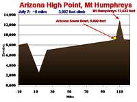
DAY 3: JULY 7, Hike: AZ Snow Bowl to Humphrey's Peak, 9 miles, 3,443 feet elevation gain
After our Uintas backpacking trip to King’s Peak we (all family and our long-time friend Charlie) were looking for another chance to get together. We talked about a lot of options but settled on Northern Arizona with its famous canyon and chance to get above the tree-line. As we are a collection of family/friends who come from quite a range of locations (see above), this trip presented a host of logistical hurdles---especially when we elected to add in some cycling. Our aim was to cross the Grand Canyon from North to South Rim on the first day, cycle from the South Rim to the base of Humphrey’s Peak on the second day, and climb Humphrey’s on day three. We started planning this trip in the fall of 2006, dividing up the different concerns (lodging, routes, meals, etc) amongst us.
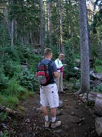
![Perparing to Go]()
We met in Sandy, UT, at Meg’s parent’s place, and drove to the North Rim on July 4. We had no trouble pulling the borrowed trailer with our bikes and other gear. This was everyone’s first trip to the North Rim. We set up at the North Rim Campground ($9 per night with Joe’s Golden Age Passport) and then went to see the rim before it got dark.
There was a small Independence Day parade going on and parking was tight. Meg and I couldn’t help but talk about coming back to stay in the lodge the moment we set foot in it. The North Rim is spectacular. I’d only seen the view from the South before, and this was clearly superior. We snapped some standard tourist photos. We started to get pumped when we recognized that we could see across the canyon to Humphrey’s Peak on the horizon.
![Joseph at North Rim]()
Back in camp, Meg and I were tasked with dinner the first night. We served spaghetti and meatballs. The weather was ideal—clear in the 70s. After dinner we started to pin down our final start time. We have respect for the Arizona desert and understand the risk that comes with a single day crossing of the Canyon in July. I’ve seen the full spectrum of dehydration and heat-stress illness at work and the last thing I wanted to do was manage any illness on vacation. We are a relatively conservative group. Between us we had 9.5 kids to assure we got home for (thanks Mom for watching our 3).
The biggest thing to remember about this hike is that it is essentially an inverted peak---the return is always harder than the descent. That means if you have trouble (unlike a peak where you can turn around and go downhill) things are only going to get worse as you continue. The park service highly recommends against trips to the river and back on the same day. You’ll see many signs in the Canyon stating this (actually, the signs say something like you will die if you do this). People do die every year in the Canyon. In the summer they helicopter people out from the Canyon nearly everyday. The park service doesn’t just say this, a friend of mine backpacking in the canyon watched a least one helicopter evacuation all three days he was below the rim. While helicopter trip over the Canyon would certainly be spectacular, doing it on a stretcher---you’ll miss all the views and the expense will be tremendous.
In emailing the Park Service about our trip they predictably said the following:
Thank you for your interest in Grand Canyon National Park. Here are links
for getting a backcountry permit: People began applying for travel in July
on March 1. The North Rim does not open until May 15, 2007. It is
recommended NOT to travel a rim to rim hike at all in the months of June,
July, and August, due to extreme heat danger and excessive temperatures of
120 and 130 degrees F in the inner canyon. Be sure to read this link and
follow the precautions (NO hiking in the inner canyon during 10 am and 4
pm) for the months of June, July, and August. This hike requires at least
3 nights below the rim, don't do it in a shorter time.
Also read the book "Over the Edge: Death at Grand Canyon" and pass it
around the people in your group to read, this will prepare you for safe and
informed hiking. Unless someone has actually hiked the Grand Canyon, no
matter if they are a mountain climber, backpacker, or marathon runner, they
will not be prepared for what you are suggesting and we strongly advise
against this undertaking, especially in July. Do some long day hikes in
the Grand Canyon, such as to Indian Gardens or Skeleton Point, with your
group and see how individuals fare, then go from there in planning
something more.
www.nps.gov/grca/planyourvisit/hike-smart.htm (summer hiking dangers)
www.nps.gov/grca/planyourvisit/backcountry.htm (backcountry hiking)
www.nps.gov/grca/planyourvisit/backcountry-permit.htm (backcountry permit)
www.nps.gov/grca/planyourvisit/campsite-information.htm(backcountrycampsites)
www.nps.gov/grca/planyourvisit/hiking-faq.htm (backcountry questions)
Park Headquarters
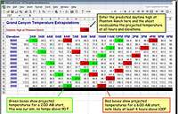
To help with our heat avoidance planning, we developed an interactive spreadsheet system where you enter the predicted daytime high at Phantom Ranch and the sheet calculates the predicted temperature at each elevation and hour along the route. We developed this tool using some standard Arizona temperature curves over 24 hours (not Canyon specific which would have been ideal) and then correcting for the temperature change at different elevations (using the standard ~5.8F temperature decline for every 1,000 feet elevation gain).
The predicted daytime high at Phantom Ranch for July 5 was 116F---at the high end of the spectrum. Our goal was to complete the rim to rim and not see the mercury rise above 90F. After some debate (heat avoidance versus sleep deprivation) the heat avoidance faction prevailed and we decided to leave about midnight. That left us with about two hours of potential shut eye—I, for one, may have gotten 30 minutes. It’s hard to sleep when you’re excited.
DAY ONE: RIM TO RIM
The alarm went off, we roused the troops, quickly finished our preparations and drove to the North Kiabab trail head (elevation 8,241) a couple miles away. Our “Canyon Team” was Charlie, Jeff, John, Kristin, Meg and I. As we started the descent, we crossed through “pockets” of relatively cold air. The night was clear and with the moonlight reflecting off the light-colored canyon walls, several of us doused our headlamps.
It was an uneventful trip down, passing Cochino overlook (not much to see in the dark) and Supai Tunnel (water refill here). We took a longer break at Roaring Springs (water refill here) and said hello to a scorpion in the outhouse. At Cotton Wood Camp (6.9 miles and 4,000 feet elevation) we first saw other people, backpackers still bedded down. Somewhere past Ribbon Falls we lost the trail as it came through thick brush and several water crossings. With steep canyon walls on each side and very dense thickets it was in no way obvious how best to proceed. We hit several dead ends in the brush, tried our way down the river a couple times, and finally picked up what seemed to be the trail again on the other side. We probably wasted 30-60 minutes on this section. I’m sure it would have been easier in the daylight, but all in all it wasn’t bad; it added some excitement to the otherwise monotonous descent.
The route flattens out through Box Canyon. John was anxious to pickup speed and began working in some running. He was the wise one in running shoes. I hadn’t been in the Canyon in more than a decade and I had forgotten how smooth the trails are. There is no need for hiking boots on the main “highways” through the Canyon like the Kiababs and Bright Angel. I ended up with some blisters, which I stopped to manage along the way in Box Canyon. It was really nice to be able to chat with Charlie, Jeff and Kristin as we traveled.
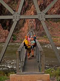
![Crossing the Colorado]()
We finally hit Phantom Ranch (13.8 miles, 2,400 feet) as the sun came up, about 6 AM. It took us longer than I expected. To prepare for this trip I had walked to work several times, a touch more than 12 miles one way, which I would do in a little under 3 hours with a loaded pack. It was still very early and we only saw a couple folks about. We stopped at the Ranch for a while to refill water, readdress our feet, and eat a little more. Some of us were hoping to get our National Park passports stamped at the ranch, one of the more difficult stamps to get, but unfortunately we arrived too early for anything to be open –what a disappointment! Despite the let down on the stamps, we were all feeling well except Jeff who had been battling GI type discomforts all night long.
We chose to ascend Bright Angel, rather than South Kiabab, as there is more shade along the route and a number of dependable water stops, although it is longer. From Phantom Ranch one continues along the Colorado River for roughly two miles before finally starting the climb up the south side at mile 15.7.
As the sun began to rise, John was anxious to avoid heat exposure near the bottom of the Canyon and took off again, mixing in some running when he felt like it. Somewhere between the river and Indian Gardens (18.8 miles, 3,800 feet) Meg, Charlie and I got ahead of Jeff and Kristin.
Jeff still wasn’t feeling well and Kristin hung with him---we never leave anyone alone. There isn’t much to say about the climb out other than the higher you go the more people you start to see.
The mule trains are fun to watch pass---but a little dusty and smelly. I don’t think there are any on North Kiabab. We would pause briefly whenever the trail crossed or came near the stream to wet ourselves/hats/bandanas. It felt good but it wasn’t really too hot. I believe we were successful in keeping the temp always below 90.
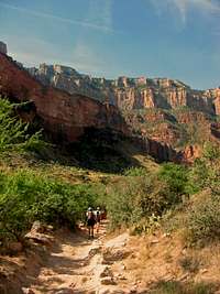
![Meg and Charlie Bright Angle]()
Passing Three Mile Rest House (20.4 miles, 4,920 feet) and One and One-half Mile Resthouse (21.9 miles, 5,720 feet) we felt tired but nothing abnormal. We chatted with other groups as we climbed. I don’t believe Meg, Charlie and I were passed as we came up through all the people towards the top of the Canyon. We finally broke the Rim at Bright Angel Trailhead (23.4 miles, 6,785 feet) about 11AM. John was waiting for us in the shade, having been up a full hour. It was very comfortable with the breeze in the shade. We walked over to some of the buildings to get some water. In less than an hour or so we met up with Joe, Joseph and Stacey, who had driven around the Canyon that morning with all the gear.
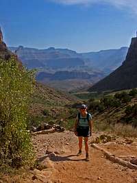
![Meg Bright Angel]()
We waited for Jeff and Kristin some time. I started to get a little nervous and walked down the trail to a spot I could get a good view of who was coming up. I watched a California Condor drifting overhead, hoping he wasn’t eyeing my siblings as his next meal. I have always wanted to see one. Aside from the condor and scorpions, the only other wildlife of interest we saw the whole trip were a couple Mule Deer, including one in velvet, feeding on the very steep slopes below the North Rim on Fourth of July evening.
John and Charlie rode bikes over to the camp and we continued to wait for Jeff and Kristin. They finally made it out about 1:00. Kristin looked irritated at the slow progress but otherwise well. Jeff looked clinically dry. He said he was nauseous most the way up but kept pushing fluids and eating as instructed. No one said they really got too hot. I would have dropped a couple liters of i.v. fluids in Jeff if I had the foresight to bring along supplies---certainly something I’ll consider for future trips with a significant dehydration risk.
I wanted to cycle from the trailhead into camp in an attempt to complete the total distance without a motorized vehicle. I borrowed Jeff’s Mt Bike (the easiest to access) for the couple mile ride into camp. Joe, Joseph and Stacey had camp all set up and we just relaxed in the afternoon. We took showers and did laundry in the bathhouse (bring your quarters). Jeff was down a long time recovering but was ready by dinner to get up and head over to the dining hall. After dinner we ate dessert in camp and hit the sack early.
DAY TWO: PLATEAU CYCLE
Our objective for day two was to ride from the North Rim of the Grand Canyon up to the base of Mt. Humphrey (AZ high point). The route is unique as it allows you to experience riding through some desert, high plateau scrub, and lush conifer forest all in the same ride. We had planned to leave the National Park and head South on US 180/64 to Valle and then turn South East, continuing on US 180.
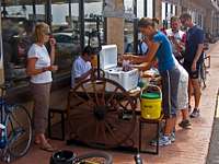
Meg and I slept pretty hard that night. I got up a little sore but excited to get on the bike. I’ve always found that any stiffness after a long run/hike is much faster to resolve if I get on the bike the next day for a good spin. Charlie fed us breakfast. The “Cycle Squad” consisted of Joe, Joseph, Charlie, John, Jeff and I. We were all on road bikes save Jeff, who rode his Mt Bike with slicks. John, Charlie and I were on borrowed bikes. We looked into renting bikes in the area, but Flagstaff was the only option (wrong end of the ride). Joe had some problems with a tire as we were preparing to leave.
Charlie, John and Jeff set out first in an attempt to get a jump on the day. My directions on how to exit the Park and hit US 180/64 were poor and they took a wrong turn and ended up riding East along the Canyon Rim for some time. They found some great views of the Canyon in the morning light, but it was the wrong way.
After we realized that Jeff, Charlie and John were on the wrong route, we sent the day’s support team (Meg, Stacey, and Kristin; with Joe along for portions as he was still working on his tire) to drive out and find them. By the time the wayward trio were located they had ridden some 20 miles or so. They packed their bikes back in the trailer and the girls drove them that same distance down the road towards Valle and then let them out to restart the ride.
The cycle from South Rim to Valle on US 180 is generally an elevation loss and not terribly interesting. Their ride along the rim was certainly better. I had spoken with a bike shop in Flagstaff about possible routes and they said that their shop used to run weekend rides out to the South Rim along US 180. Traffic wasn’t bad at all as we headed south. There was more traffic headed north towards the Canyon (logical for weekday morning).
![Dinner Day 1]()
Joseph and I stopped outside a truck stop in Valle. It was new, clean, and had some nice picnic tables and shade. We waited for everyone and then ate lunch. Kristin was in charge and did a great job. Back together, we continued the ride on Hwy 180 as it turned southeast and started to climb. I quite enjoyed the ride from Valle to the Arizona Snow Bowl. The road was in great shape, very light traffic, with nice curves and climbs. Joseph, Charlie and I stayed together up until where the scrub oaks just started to transition into conifer forests. The girls had set up a Sag stop there. Joseph wasn’t feeling well and decided to call it a day. Charlie waited for the other riders to catch up. I elected to go ahead and keep climbing. I hit some very heavy wind and light rain up on a plateau about 65 miles into the ride, otherwise, the weather was great. I love the smell of newly damp conifer forests—something we don’t get in Indiana or Ohio.
After I arrived at the Arizona Snow Bowl Lodge, I checked in to our three rooms ($100 per night, for two queen sized beds). The lodge wasn’t much to look at but seemed clean enough and the location was ideal (http://www.arizonasnowbowl.com/lodging/index.html, Snowbowl Lodge: 928-774-0729). We had talked a lot about camping this night as well but had trouble finding a great location and with Stacey eight month’s pregnant, this seemed the kindest choice. There do seem to be some primitive camping options in the Hart Prairie area. The Lodge sits on Hwy 180 just at the base of Snow Bowl Road (NF 516), some 7 miles below the Ski Lifts and the Trail Head to Humphrey’s Peak.
After a spell, the girls drove in and I went out with them in the car to check on the other rider’s progress. Everyone was doing well and it wasn’t long before we were all at the Lodge. John’s bike (an old Diamond Astler of Joe’s) had a rear tire blow out that was not patchable somewhere between Valle and the Lodge. Out of extreme generosity and kindness, Joe insisted John take his bike and finish the ride.
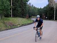
John, Jeff, Charlie and I saddled back up for the final climb up Snow Bowl Road (NF 516). The weather was a little cool---great for climbing. It was a bit of a slog up the 7.1 miles and 2,132 vertical feet climb to the trailhead (9,200 feet). We were passed by some local cyclists. If we were fresh it would have been a great climb---the kind I’d love to do every week or so if I lived in Flagstaff. Not quite as nice as the cycle up Little or Big Cottonwood Canyons in the Wasatch, but a good climb. The girls met us at the top and we took photos.
The ride down wasn’t quite a dare-devil decent but I did get moderately cold in the afternoon cool with the wind chill, even with the extra layer I had carried. I was proud of Jeff’s ride, no easy feat on a mountain bike with slicks after the previous day’s Canyon crossing. Including the ride down Snow Bowl Road, the day’s total cycling mileage was just over 85 miles.
Back at the lodge we cleaned up and drove into Flagstaff to eat dinner. We ate at a Mexican joint. The food was reasonable, but not noteworthy enough to remember the name or give a recommendation. We stopped by Wal-Mart on the way home looking for some trekking poles to use on day three. We thought they might help our tired legs on the descent of Humphrey’s. We bought several pairs of the inexpensive “SwissGear” poles that go for $15 a pair and have telescoping length adjustment and some spring action. I’ve seen the exact same poles at Dick’s Sporting Goods for $20 a single pole. If you’re looking for inexpensive poles that will do a reasonable job, just go to Wal-Mart.
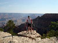
DAY THREE: HUMPHREY’S PEAK
Everyone was planning on Humphrey’s Peak except Stacey who was, of course, a little more pregnant every day. We drove up to the trailhead and got started about 9:00. The air was still damp and the temperature cool. Humphrey’s is really a nice half-day hike.
The trail winds up through the conifers, finally breaking the tree-line for spectacular views to the North including the Grand Canyon and towards Flagstaff to the South. It was a Saturday and we ran across a number of other groups. John was excited to climb again and took off ahead.
The only thing to really worry about on Humphrey’s Peak is afternoon lightning. It is never smart to be at elevation when nature’s fireworks start showing. There were thunderstorms both afternoons we were in the area but very little actual precipitation fell. Luckily, the lightning is easily avoided on the peak with a morning start. The trail up Humphrey’s is strait forward.
Aside from the summit being plagued with gnats, it was glorious place. I never seem to get over the magic of being above the tree-line. We met a woman on top who, each year, hikes South Rim to North Rim, spends the night at North Rim Lodge, and hikes back to the South Rim the next day; a great tradition. We took our share of photos and headed down. I was glad to have the poles on the way down. Back at the trailhead we enjoyed some rice-crispy treats Meg had hidden away. What an amazing feeling to have finished!
DEPARTURE & CONCLUSIONS
We left the Snow Bowl and drove back North. We were meeting other family at a vacation home in Saint George that night. A number of us were flying out of Salt Lake City in the early afternoon the next day. We stopped at a couple spots along the way, including a bridge over the Colorado River, where Kristin caught our best sides.
The entire trip fell together nearly exactly as planned. I was very pleased with the hiking and cycling routes, the accommodations, nearly everything. The only thing I would change would be to swap out boots for running shoes in the Canyon and to work a little harder to avoid any mechanical problems with the bikes.
Northern Arizona is a truly amazing place. To travel from the blistering rock and sand at the bottom of the Canyon, across the desert, up through lush conifer forest, and then back to the barren rock above the tree-line in a touch over 24 hours can not be done many other places.
ACKNOWLEDGEMENTS
Thanks to Pat and Anna for the trailer, bike, and lodging in St George; to Joe and Anne-Marit for the bikes and getting so much ready (there’s a grocery store in their basement); to Ariel for the extra vehicle; to Mark and Greg for the maps and Arizona-specific intel; to John and Myrna for tending our brood; to Kevin for the bike; to Sarah and Katherine who let their husbands come and managed their boys alone; to Stacey for all the driving, physical and emotional support; and to all who signed on to one of our crazy trips. As always, Meg and I are blessed to have such wonderful family and friends to share our adventures.


Comments
Post a Comment