Grand Canyon - Hermit's Loop
March 28-30, 2009
Total Distance - 31 miles
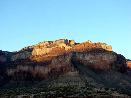
![Sunrise]() Sunrise
SunriseArriving at the Grand Canyon
Arriving outside Grand Canyon Village at the South Rim a bit after eight o'clock we checked the Best Western for availability. We managed to get a huge room for a reasonable rate. Not wanting to go to sleep yet we went down to the bar for a cold beverage then headed back to the room to get some sleep.
Day 1: Down we go
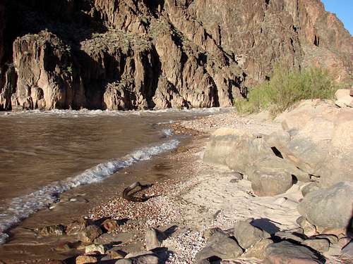
![Granite Shores]() Granite Shores
Granite Shores![Sunset]() Sunset
Sunset![Hermit Road]() Hermit Road
Hermit Road![Pillar]() Pillar
Pillar![Monument Pillar]() Monument Pillar
Monument Pillar![Cathedral Stairs]() Cathedral Stairs
Cathedral Stairs![Almost there]() Almost there
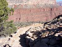
Almost there![Lookout Point]() Lookout Point
Lookout Point
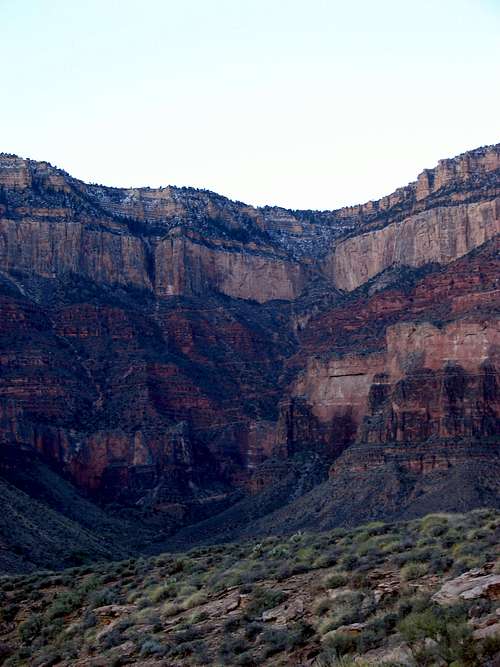
Although the alarms went off at 6:00am most of us were already awake. Quickly putting on our hiking clothes and packing things up we headed upstairs to grab a free breakfast at the hotel before heading out. The overnight low was 16 and by 6:30am it hadn't warmed up much. Parking at the Backcountry Office and hiking a short distance to the pickup point for the Hermit's Rest bus we noticed it was significantly warmer. After a 40 minute ride out to Hermit's Rest we finally hit the trail.
There were no clouds in the sky and the sun warmed up quickly once we started hiking. Within 30 minutes we had to stop to strip our warmer layers. While the trail was well marked it did get rough in spots requiring us to slow down a bit in sections. We made steady progress and decided to take a break at Lookout Point which was about 5,000ft; 1,800ft below where we started. A number of other groups stopped here to eat and enjoy the views. Continuing down the trail we got closer and closer to joining the main canyon from the side canyon where we started. We stopped again at Breezy Point for another snack and pictures and to talk to other groups on the way up. One group informed up that Monument Creek was running at the top in the narrows then went underground, however, it came back out about 100 yards up from the Colorado River. This was important for us since it was to be our source of water that night. Just after Breezy Point we descended the Cathedral Stairs. Even though the trail was incredibly steep it was well constructed and made for a quick and easy descent. After a few more switchbacks we reached the turn off for the Tonto Trail. This would lead us to the Monument Creek Camp and the turn off trail for our destination, Granite Rapids. The Tonto had a few ups and downs but we quickly reached the head of Monument Creek. Dropping down into the creek bed of Monument Creek we had about 1.5 miles remaining for the day. This part of the hike was more difficult since we were hiking on nothing but loose rock and sand. We passed another group coming up that taken a side trip to Granite Rapids. A few minutes later we heard the roar of Granite Rapids and saw a large sand dune off to our left. Climbing the dune we had found our camping spot for the first night. We were the only group there and had our choice of spots. Before preparing our site we dropped our packs and head the 100ft to the shore were we took our boots off and stepped into the frigid water. Within seconds our sore feet were numb and it felt wonderful. After our time at the beach we set up camp and found a good area for cooking, got the stoves started and pumped some water. Once dinner was over I strung som cord between two rock outcroppings to keep the squirrels, lizards, and anything else away from our food. The thin 1.5mm cord sagged badly but kept everything about 3ft off the ground and we figured it would be fine. We finished the evening by watching the sunset then headed to bed even though it was still light out. Laying on the warm beach sand on top of my sleeping bag with the rush of the river behind me was wonderfully relaxing. Slowly the stars came out and I was able to count a handful before I fell asleep. A few hours later I woke up to a sky bright with stars and a cool breeze. Zipping my bag up further and looking at the stars I was asleep again in no time.
Day 1 Mileage: 11 miles
![Last Rays]() Last Rays
Last Rays![Beach Flower]() Beach Flower
Beach FlowerDay 2: No Man's Land
![Camp]() Camp
Camp![Looking Back]() Looking Back
Looking Back![Horn Creek]() Horn Creek
Horn Creek
I arose to daylight with a few clouds in the sky and the others moving around the camp. I got up and joined in helping getting breakfast ready and breaking camp. During the night a squirrel had stolen a small piece of bagel Chris forgot about and not been hung up. Other than that our line worked well enough to keep the rest of the critters out. After eating breakfast we began packing up and pumped more water since there would be no water until our camp that night at Indian Garden. Returning from camp after getting water Jered told us he had seen a bighorn sheep up on a rocky slope. I grabbed my camera and climbed up to try to see him but he was already gone.
The second day's hike brought us back to the loose rock and gravel of the dry creek bed of Monument Creek. At the campground we talked to another group that had been there for a few days before beginning the steep ascent back up onto the higher portion of the Tonto Trail. This portion of the hike feels like a true desert hike, with nothing but sparse brush, cacti, and small lizards running over the sand, dirt, and rock. On the map this trail looks like it follows the contour of the land and has almost no gain but it is far from the truth. While there are no steep ups and downs like many other canyon trails the Tonto trail gradually loses and gains several hundred feet at almost every side canyon.
Our first major side canyon that we had to get around was Salt Creek. We hiked back into the canyon looking down at the dry creek bed. This side canyon was impressive with thousand foot vertical canyon walls before joining the rest of the Grand Canyon. We were able to see a tent or two down near the dry creek bed although we saw no people at the camp. The trail crossed the creek bed higher up from the camp and we decided to sit on the cool rock and take a break. We had already gone 5 miles and had used a fair amount of water. Unfortunately Salt Creek is to highly mineralized to filter potable water although it was almost completely try as well. After looking at the map and mileages I found we had 7 miles remaining even though I had originally thought it would be an 11 mile day. After much heckling from the others we got back on the trail with two buttes and one more major side canyon to go around. Upon exiting Salt Creek and coming to the point at the end of Dana Butte we stopped for a short break and looked back down river and to our surprise we could still see where we camped the night before. After nearly 8 miles of hiking we were still easily in sight of our campground from the previous night. Pushing that out of our minds we continued our trek down our second major side canyon, Horn Creek. As with Salt Creek it seemed to go on forever. The canyon would branch requiring us to go even further back from the inner canyon. Finally we came to the main creek bed of Horn Creek which was nearly dry. As with Salt Creek the water is undrinkable but this time it is due natural uranium deposits upstream. A few trees sprouted bright purple flowers in the creek bed but the area was just as much desert as the rest of our hike. At this point we were tiring a bit and moving slower. I was a bit concerned with our water supply although we only had about 2.5 miles remaining. Our last obstacle was Cope Butte. Once we rounded that it was a straight shot to the Indian Garden Campground. Hiking around Cope Butte was very much the same as hiking around Dana Butte. The last few miles went quickly and we soon can to a junction with the trail that leads to Plateau Point. Here we ran into the Ranger staying at Indian Garden and we realized this was the first person we'd seen since Monument Creek Camp. That's over 10 miles of hiking in the Grand Canyon without seeing a single other person. We talked with the Ranger a bit then headed over to the camp.
The camp area was nearly full and much louder than the previous night. We set up camp and cooked dinner then sat around for a while before going to bed. Just before bed we saw numerous mice living in the rocks near our camp. Since I was in a bivy sack that had an open face I was hoping I wouldn't wake up with a few extra friends in the night. Brett and I were planning on waking up at 5:00am and hiking to Plateau Point for the sunrise. Jered and Chris were going to sleep in a bit then start cooking and breaking camp. As night fell a large cloud rolled in and started dropping some rain about an hour after we went to bed. While the rain kept the mice in their holes it didn't help me. I rolled over and pulled the bivy over my head to protect me from the rain. The temperatures dropped quickly and the rain became a snow/ice mix for a short time. Originally the low for the area was 40 but later we found out it had dropped into the 20's. In my 30 degree bag I was okay for a while but the condensation inside the bivy slowly got my sleeping bag wet and I awoke in the middle of the night a bit chilly. Unable to fall back asleep, I laid there for a while slowly getting colder. I knew getting out of my bag at 5:00am would be unpleasant but I also knew it would give me the chance to move around and warm up.
Day 2 Mileage: 12 miles
Day 3: Up and out
![Bright Angel]() Bright Angel
Bright Angel
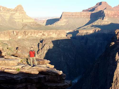
As I was trying to decide if I should get up and go with Brett or not I felt a small rock hit my bivy, then another. Brett whispered from his bivy it was time to go. I got out, grabbed my clothes and put them on shivering for the first few minutes. Once dressed, I grabbed my camera and water bottle and we were off for the 1.5 mile hike to Plateau Point. Although the sun was still an hour away from coming over the horizon it was bright enough that I turned my headlamp off shortly into the hike. We reached Plateau Point in 30 minutes to see a Raven standing on a safety railing. As we approach he squawked at us but didn't budge. Every step we took he would squawk but stand his ground. We went over to the far side and left him alone. After 20 minutes of waiting in the cold we saw the first rays of sun hit the upper part of the south rim. The shadows slowly retreated and we got some great pictures. After 40 minutes of enjoying the views and taking numerous pictures we decided to head back to camp.
![Young Buck]() Young Buck
Young Buck
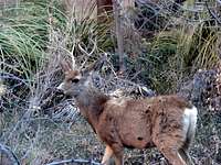
Arriving back at camp we found lots of activity. Almost every person from every campsite was cooking and breaking camp, getting ready for the trek out. Jered and Chris had already eaten and were working on packing and breaking down their tent. Brett and I at a quick cold breakfast and packed our bags. While packing we had a visit from two young buck mule deer at the campsite. I got a few pictures of them before they moved on.
We got on trail about 10 minutes behind the group from the camp next to us although we caught them quickly. We got off to a slow start having to stop to take off layers or adjust packs but after the first 3/4 mile we got into a good pace. The first rest house seemed to come quickly and we took a short break there and enjoy the nice views. After about 10 minutes we were off again with a quicker pace even though we were tired. At this point all we could talk about was cheeseburgers, wings, or beer since we had been eating mostly freeze dried food for the past 3 days. Shortly before the second rest house we began seeing the tourist crowd. We chuckled at what some where wearing or carrying but got rather tired of some of their questions. Although our pace was quicker it felt like it took a lot longer to reach the second resthouse. Again we took a 10 minute break before starting up again. At this point we were running into some fresh snow on the trail that had fallen the night before. Fortunately, there wasn't enough to make thing slippery or difficult. This last 1.5 miles seemed to take forever, perhaps because every tourist looked at us and said "You're almost there". After about 45 minutes of dodging mule trains, listening to stupid questions and seeing people hiking in t-shirt and shorts on a 30 degree days we had finally make it to the top of the trail. A quick hike over to the Backcountry Office where the car was parked and we were done.
Dropping our packs we opened the car and grabbed our sandals and clean clothes waiting for us. It felt so good to get the boots off and some clear clothes on. On the way out we grabbed some snacks at the gas station to hold us over. Our lunchtime destination was Buffalo Wild Wings in Flagstaff. We were all very tired but it had turned out to be a great trip.
Day 3 Mileage: 8 miles
![Bright View]() Bright View
Bright View![Canyon and River]() Canyon and River
Canyon and River


Comments
Post a Comment