The Way of the Grape
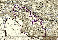
![Grapevine Profile]() Grapevine Loop Profile
Grapevine Loop Profile![Grapevine Loop]() Grapevine and beyond
Grapevine and beyond report is a continuance of a larger report about South Rim Trails and Routes from Lava Falls to Sapphire Canyon. These reports started with the
Escalante Route. The Grapevine Loop is Part 3 of 6 directly linking it to Part 2 of 6;
Horseshoe Mesa Combinations in the east and the Bright Angel/Kaibab Loops in the west. There is information there that may help you should you choose to circumnavigate Horseshoe Mesa from the Escalante/Tonto area to continue with the Grapevine Loop.
From a Hikers Journals
“….She let out a truly concerned sort of a whine and commenced to warn me sharply of encroaching danger. She was 70 feet behind me. ‘Bob, there is a small creature running straight at you.’ She was very excited. She did not know what would behave is such a way in this place.
I turn only to be quite startled about a small varmint that seemed to be hell bent on my instant demise. It was 30 feet away and closing at a speed I could not react to. My only reaction was to be astounded anything would want to get at me so I prepared. I’m on a skree slope so I cannot dive so I kick some pebbles as my only defense. As it turns out, my friend scared a ground squirrel and its most timely escape from her was to run full steam up trail looking over its shoulder at her all the while. It did not see me and the poor fellow almost crashed right into me. Scared all 3 of us half to death.
For 45 minutes we laughed our asses off. Every 10 to 30 minutes for the rest of the day my friend would bust out in a hysterical laugh from a dead silence and I’d start laughing right in behind her.” Ahh, memories.
This report is not from one trip but rather bits and peices of many trips across the Grapevine Loop through the years. This loop encompasses the
Grandview Trail, the Grapevine section of the Tonto Trail and the South Kiabab Trail and is 26.7 miles in length. I hope you enjoy this just as much as I always have. We'll start at the Grandview Trail and Horseshoe Mesa.
Grandview to Cottonwood
![Cottonwood Creek]() Cottonwood Creek
Cottonwood Creek![Grandview Profile - West Spur]() East Spur off Grandview - Trail Profile
East Spur off Grandview - Trail Profile
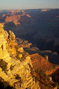
I've often mention that the top of the Grandview Trail is probably some of the prettiest trail locally as there is in the Grand Canyon with all of its twist and turns in and out of ledges and around countless drops and it even rides in a saddle that splits two major side canyons for a distance. The walk to Horseshoe Mesa is spectacular. About 1100 feet below the rim is a place know as “The Saddle” and is a wonderful cool place to stop for a snack. You’ll know The Saddle when you see it. Just below The Saddle there is a slick section skirting a tiny drainage head that sometimes washes out leaving some pretty good exposure under foot. Soon afterwards it’s a relatively straight descent on to Horseshoe Mesa. You won’t be into Horseshoe Mesa very far before you run into the old stone miner’s cabin with a trail marker just before it pointing the way to Cottonwood Creek. You will have no questions as to whether you’ve started the drop over the Mesa. It’s straight down for several hundred feet. Soon enough you’re at the bottom and you will see the creek bed. Listen for water as you usually hear it before you see it. Fine camping can be had at Cottonwood creek and Cottonwood Creek represents the start of the Grapevine Loop. It is 4 miles from the rim to Cottonwood with an elevation loss of 3700 feet.
OK....On to Grapevine
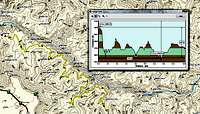
![Grapevine Profile]() Grapevine Profile
Grapevine Profile![North Rim from Creamation Canyon]() Looking back upon the Grapevine Loop from Creamation Canyon.
Looking back upon the Grapevine Loop from Creamation Canyon.
Reaching the River is illusive on this stretch of the Tonto. The walking is amongst the easiest in the Canyon as it stay on a relitively level Tonto Shelf but the route stays 1200 above
The River for it's length. There are routes to the river but they are not established, are dangerous and are beyond the scope of this report. Though there is a good chance that there is water in the Cottonwood drainage, there is a very real possibility that there won't be any water all the way to Grapevine Canyon. BE PREPARED!
Cottonwood Creek is fine camping but is socked back in a side drainage. We start out of Cottonwood watered down like a Camel but the walking is easy enough and the Canyon starts to open up before us. Before long we get some really fine views of the ancien Vishnu Schist and the plummiting inner gorge. Walking on the lip on the Inner Gorge on the Tonto Shelf is a walkers paradise. The view is ever changing and one just barely starts to get a sense of just how massive the Grand Canyon really is.
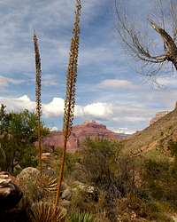
Grapevine Creek drainage goes on seemingly forever. You think maybe a half mile across but it takes hours to round the head of the drainage to find yourself on the opposite side. Also, some places along the rim of the Grapevine Drainage are very precariously close to the great abyss. Caution in footing is advised here.
Often time, most times, water can be found in Grapevine in the east arm. Sometimes in late spring there are wonderful cooling pools in both arms of Grapevine. Many people choose to set up camp here. Some layover for a second night as there is plenty and varied exploration up in the various side drainages behind the trails.
As I mentioned earlier, it takes forever to walk out of the Grapevine Drainage but that’s not to complain. There are many views of polished pore-offs and the way keeps feeding you hints of the new canyon that will eventually unfold before you. If you have some pack-off time, there is some great scrambling downstream in the west fork of Grapevine before you walk to far away from the head.
Swinging around the head of Boulder Creek is easy enough. I generally chose to risk high winds sneaking up on me in the evening as I camp out on the point over the Inner Gorge on the east side of Lonetree. I get here early enough to make a water run to the head of Lonetree Canyon where I can usually find water, but not always. This is one of the panoramas that are both high and low and 360* of awe and I like to watch the starts come out here. The Milky Way is an un-broken stripe from horizon to horizon. Here also is a perfect view of the
shear sidedness of the Inner Gorge and an awesome example of the forces the Colorado River has exacted on the region. If you prefer, there is some great shelf camping 20 feet above the babbling Lonetree Creek at the head of the Creek where I just got water.
Then there is Cremation Canyon. The free ride is over. On you topo map you will barely depict 3 tiny forks that the trail crosses and in your trip planning you will probably pay then no mind but the Canyon will fool you. I come upon the east fork of Creamation and it is loose slide and straight down for a couple hundred feet. I go down on my behind time and time again. 30 feet of flat creek bottom and we are heading straight up a very loose and steep canyon wall just like we just came down. I get a few hundred yards of relative gentle reprieve when I come up on the Middle Fork of Cremation and it’s straight down and heels out from under me just the fork I just stumbled through. West for, the third in the series; identical hurdles. This mile is the toughest on the Grapevine section of the Tonto. Because of the nature of these minor barriers on the Tonto, day traffic from the South Kaibab will usually turn around here. If you want just one more night of quite in the wilderness, you best stay east of Cremation your last night. Yet there is a well established camp just west of Cremation that affords one of the
best sunset vantage points on this popular route as depicted in the
panorama on this page.
Just around the corner is the junction with the South Kaibab Trail and the end of the Tonto section of the Grapevine Loop. Because the Kaibab and Bright Angel trails in conjunction with Indian Gardens and Phantom ranch are the Tourist/Death March Jogger and canyon conqueror trails, I will leave the Kaibab trail section of the Grapevine Loop for report 4 in this series of 6, Bright Angel/Kaibab Combinations. Just pick up the Kaibab at the junction and go ever upward.
The Trailhead
There are two Trailheads for the Grapevine Loop. The Grandview as discribed here and the Kiabab which will be discussed in depth in the Bright Angel/Kiabab Combinations section of these reports
Grand Canyon Village, home of the Backcountry Rangers Office is 60 miles north of Williams Arizona via highway 64 with well marked exit signs along the roadway. The office is 80 miles north of Flagstaff Arizona via highways 180 and 64 but we’ve already obtained our permits so we are not going to the BRO. We are going straight to the trailhead.
The Grandview Trail trailhead is located at the Grandview Point scenic turnout along the South Rim Drive. Travel 12 miles east of Grand Canyon Village on South Rim Drive. Turn north at Grandview Point turnout road and drive to the rim parking lots. The trailhead is at the end of the road.
DO NOT leave valuables in plain sight. Lock them in your trunk.
Lodging
Lodging is much more reasonable in Williams and has more charm than hastling with the mobs on the Rim. Leaving Williams at 4:30 AM puts you at the Grand Canyon South Rim restaurant openings at 6AM and on the trails at 7. Williams has better gift shops and dinner restaurants (restaurants priced within reason anyway) than the rim, sets under a beautiful alpine mountain and is home of the Grand Canyon Railroad.
For lodging information at the Grand Canyon proper, visit the contracted consessionier at
Xanterra Parks & Resorts.
I will add though that a Canyon view suite at the El Tovar is the finest Christams gift I ever received.
Obtaing Permits
From the Grand Canyon National Park web site
Grand Canyon of the Colorado
Backcountry Information Center
The South Rim Backcountry Information Center is open daily for walk-in visitors from 8 a.m. to 12 noon and 1 p.m. to 5 p.m. Mountain Standard Time. The North Rim Backcountry Information Center is open mid-May to mid-October for walk-in visitors from 8 a.m. to 12 noon and 1 p.m. to 5 p.m. Mountain Standard Time.
Backcountry Information Center staff answer information telephone inquiries at 928-638-7875 between 1 p.m. and 5 p.m. Monday through Friday, except on federal holidays. This telephone number is for information only.
FAX number for permits is 928-638-2125
you can send a fax 24 hours a day, 7 days a week, 365 days a year - HOWEVER the first day of every month we receive many faxes and the number may be busy
Mailing address is:
Grand Canyon National Park
Backcountry Information Center
P.O. Box 129
Grand Canyon AZ, 86023
Backcountry Permit Request Form NOTE: This is a printable form only. You must print the form, fill it out, and then fax/mail it directly to the Backcountry Information Center. Backcountry Permit Form
Backcountry Permit
If you wish to camp anywhere in the park, other than in developed campgrounds on the North Rim, South Rim, or Tuweep, you must obtain a permit from the Backcountry Information Center.
Backcountry travelers must have their permit in their possession while in the backcountry. Once a camp is established, the permit must be attached to a pack, tent, or other equipment in plain view so it can be easily checked by rangers.
Permits are valid only for the trip leader, itinerary, number of people, and dates specified on the permit. Permits for all overnight backcountry use must be obtained through the Backcountry Information Center at Grand Canyon National Park.
Reservations for overnight tent or RV camping in developed Use Areas on the canyon rims (Mather, Desert View, North Rim) are not obtained through the Backcountry Information Center. The Backcountry Information Center does not make reservations for river trips, mule trips, Phantom Ranch lodging, or trips into the canyon on the Havasupai Indian Reservation.
To obtain additional information or reservations for Phantom Ranch lodging, please contact Xanterra Parks and Resorts at 303-297-2757 or 888-297-2757 (www.grandcanyonlodges.com). For hikes into Havasu Canyon contact Havasupai Tourist Enterprises at 928-448-2141 or 928-448-2111 (www.havasupaitribe.com).
Fees
There is a non-refundable fee of $10 per permit plus $5 per person per night camped below the rim and $5 per group per night camped above the rim. Frequent users may wish to purchase a one-year Frequent Hiker membership for $25 that waives the initial $10 fee for each permit obtained by the trip leader for twelve months from the date of purchase.
When sending in a permit request, the preferred method of payment is with a credit card. Please be sure to indicate the maximum amount you authorize the Backcountry Information Center to charge so that your longest trip alternative can be considered. Valid personal checks and money orders against a United States bank are also accepted when made out for the correct amount. Please do not send cash in the mail.
Permit holders will be responsible for paying park entrance fees upon arrival.
South Bass Trail and Pasture Wash Trail visitors may be charged an additional fee by the tribe for crossing the Havasupai Indian Reservation.
How to Apply
Obtain and fill out the Backcountry Permit Request Form:
Permit Request Form
Do not forget to include the following with your permit request:
Trip leader's name, address, and telephone number.
Credit card number, expiration date, signature, date signed, and largest amount you authorize the National Park Service to charge.
Number of people and/or stock in the group (see Private Stock).
License plate numbers of any cars to be left at the trailhead.
Proposed night-by-night itinerary showing use area codes and dates for each night
Organization name if applicable (see Group Size and Commercial Use below).
Alternative proposed itineraries.
Submit the permit request form in one of the following ways:
Most competitive: Bring request in person to the Backcountry Information Center.
Preferred and most competitive written method: Fax request to the Backcountry Information Center, 928-638-2125.
NOTE: You can send a fax 24 hours a day, 7 days a week, 365 days a year - HOWEVER the first day of every month we receive many faxes and the number may be busy.
Mail request to Backcountry Information Center / GCNP, P.O. Box 129, Grand Canyon AZ, 86023.
The Backcountry Information Center treats all requests on a first-come-first-served basis with the following two exceptions:
immediate assistance is given to walk-in visitors, essentially moving them ahead of unprocessed requests
on the first of the month only, four month prior to the proposed start month, all faxed requests received by 5 pm are processed randomly (getting your fax in at midnight on the first does not give you an advantage over another person who sends a fax at 7am).
When to Apply
The earliest you can apply for a permit is the first of the month, four months prior to the proposed start month (see table below). Applying as soon as allowed will improve your chances of obtaining an overnight backcountry use permit for the dates and use areas of your choice.
For dates during the month of: Apply on or after:
January - September 1
February - October 1
March - November 1
April - December 1
May - January 1
June - February 1
July - March 1
August - April 1
September - May 1
October - June 1
November - July 1
December - August 1
Mailed requests must be postmarked no earlier than than the date indicated on the chart. Faxed requests must not be received earlier than the date indicated on the chart.
Permit Responses
All requests are responded to through U.S. Mail - never by fax or e-mail. Due to the volume of requests received, the park cannot confirm receipt of requests until they have been fully processed. Please allow at least three weeks for processing.
When space is available and all fee requirements are met, a permit will be issued and mailed to the trip leader. The permit is valid only for the trip leader named on the permit. Overnight hikers are not permitted to enter the canyon without a valid permit in the trip leader's possession.
If you have been denied a permit through the mail, you may want to consider day hikes or attempt to obtain a last minute, walk-in permit.
Last Minute Permit Availability
People without a permit may be able to obtain one upon their arrival, in person, at the Backcountry Information Center. However, permits are very difficult to obtain during popular seasons.
When demand for campsites exceeds supply, a waiting list procedure is implemented. Participation in this procedure is limited to walk-in visitors only. Obtaining a same-day permit is unlikely; anticipate a 1 to 3 day (or longer) wait.
People may participate in the waiting list for as many consecutive days as are necessary to obtain a permit. However, those on the waiting list must be present at the Backcountry Information Center at 8am Mountain Standard Time each day in order to maintain their position on the waiting list.
The South Rim Backcountry Information Center is open daily for walk-in visitors from 8am-noon and 1-5pm Mountain Standard Time. The North Rim Backcountry Information Center is open mid-May to mid-October for walk-in visitors from 8am-noon and 1-5pm Mountain Standard Time.
Use Areas
Backcountry Use Area Map
The backcountry is divided into "use areas". Each use area has an overnight capacity based upon the size of the area, the number of suitable and available campsites, its ecological sensitivity, its management zoning, and its use history. Use areas range in size from several hundred acres to several thousand acres.
Length of Stay
Camping in the Corridor, Hermit, Monument, Horseshoe Mesa, and Tapeats Use Areas is limited to designated campsites or campgrounds only. Camping in these designated campsites or campgrounds is limited to two nights (consecutive or non-consecutive) per campsite or campground per hike. One exception is made to this rule: from November 15-February 28, up to four nights will be allowed in popular corridor campgrounds.
Outside the use areas named above, "at-large" camping is permitted, meaning that camps are not limited to designated sites.
Trips are limited to a maximum of seven nights per use area; however, overall trip lengths are not limited.
Group Size
More permits are available for small groups (1-6 people) than for large groups (7-11 people). Because there are only a few large group sites, limiting the size of your group will increase your chances of obtaining a permit.
Larger groups tend to cause a disproportionately higher amount of damage to the canyon, largely due to the effects of "social" trailing. For this reason, the park's Backcountry Management Plan does not allow groups larger than eleven people to camp in the same campground or use area.
Regulations stipulate that all permits are void when a group obtains multiple permits for the same campground or use area for the same night. The alternative for these larger groups is to obtain permits for smaller groups and ensure the itineraries for these permits never bring more than one of the permits into the same campground or use area on the same night. No more than four large groups or eight small groups that are affiliated with each other may camp within the backcountry on the same night.
Sister Pages
Sister Pages for trails and routes in this report series are:
Escalante Route
Horseshoe Mesa Combinations
Grapevine Loop
Future Reports in this series will be:
Bright Angel/Kaibab Combinations
Monument Loop
Hermit/Boucher Loop and Points West
A Photo Tour of the North Rim
These pages are coming together quickly. Give me just a couple weeks to complete the initial edits.
Comments
No comments posted yet.