What Goes Down Must Come Up
The north rim of the Grand Canyon is a special place in the fall. The droves of tourist have dissipated, fewer rafting trips are making their way through the canyon, the aspens along the north rim are golden, and the crisp autumn air offers a reprieve from the scorching summer heat. Jimmy, my brother in law, and I had been planning this trip for over a year and we finally secured 5 permits for the Bill Hall TH for October 20th-24th.
We filled out our group with another one of my brother in laws, JT, and my two best friends from high school, Steven and Chance.
While I have organized and executed a lot of multiday backcountry trips with my wife, this trip was first time I have lead a multiday trip with relatively inexperienced hikers. Chance and Steven had done a few overnighters with me; Jimmy and JT had never done an overnight backpack. I meticulously plotted our trek, made gear lists, and food lists. I tried to accurately portray the difficulty of the hike to everyone and recommended working out in the months prior to the trip. I also intentionally stretched this 28 mile hike out over five days so we would have a rest/exploration day and two days to do the climb out. I felt confident that my crew was capable to make this adventure...So I thought....
Day 1: Into the Belly of the Beast![Steep section of the trail]()
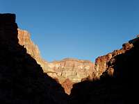
The day started out innocently enough. We got to the Bill Hall Trailhead, elevation 7000ft around 07:45 and after one last gear check and a slice of leftover pizza, we started around 08:30. The trail initially gains around 200ft before leveling off and meandering to the west for about 1/2 a mile. A large cairn on the top of Monument Point marks the spot where the trail plummets down to the Esplanade (elevation ~5400). Views of Bridger’s Knoll, the Esplanade, and main canyon offer continuous eye candy as you descend. There is one slightly tricky down climb that might be hard for people with shorter legs, but everyone in our group made it without removing our packs. We then wandered across the 3 miles of the Esplanade following the trail and well placed cairns on the sandstone most of the way. The Esplanade is dry, so we each cached one gallon of water per person near some picturesque hoodoos for our camp on the last night of our trip on the way out. If you are planning on camping on the Esplanade, the best sites are
![Tapeats Creek Drainage]()
on the rim overlooking Surprise Valley and the canyon below. Avoid stepping on the cryptobiotic soil**, which looks like someone spread small chunks of coal across the ground. It takes many years for the cryptobiotic soil to recover if crushed under a hikers boot. It was a nice morale boost to get rid of the 8 lbs of water and we all enjoyed the stellar views down into the canyon over our lunch break atop one of the many hoodoos. After lunch we started the 1500ft descent from the Esplanade into Surprise Valley. The trail is rocky, but in good shape.
**Cryptobiotic soil is found throughout the world. In arid regions, these living soil crusts are dominated by cyanobacteria, and also include soil lichens, mosses, green algae, microfungi and bacteria. These crusts play an important role in the ecosystems in which they occur. In the high deserts of the Colorado Plateau (which includes parts of Utah, Arizona, Colorado and New Mexico), these knobby black crusts are extraordinarily well-developed, and may represent 70 to 80 percent of the living ground cover.
![Thunder River]()
The first sign of trouble became evident about a third of the way down into Surprise Valley. My friend, Chance has a bum knee from playing high school football and it was beginning to flare up. I had asked everyone to hit the gym prior to the trip in order make the hike more enjoyable, but I couldn’t convince him that this applied to him as well. We made excruciatingly slow time for the rest of the day, less than 1mph. About this time, a group coming out told us about a rescue that happened early that morning. Apparently, a guy fell while exploring around the Tapeats Cave area and broke his arm and femur. At this point, I was getting extremely frustrated and somewhat concerned about the logistics of the rest of the trip.
We finally completed the 1200ft drop past Thunder River, pushed into upper Tapeats Creek camp around 6:00PM only to find 3 people already set up in our site. When I asked to see their permit they could not produce one, but generously offered to share our site with us...WTF... My first instinct was to run them out of camp, but we had already dealt with enough stress getting my gimp legged buddy down the first 4800ft of this trip to camp. We decided that sharing the site wouldn’t be that bad and it was not worth getting any more wound up over. Otherwise, the campsite was nice, surrounded on all sides with red wall cliffs. We cooked up some mountain house and called it a night. Chance was too tired to eat or drink much. I knew this would set him up to have another bad day, but hoped a good night’s sleep would make the difference.
Day 2: Trouble on the Colorado
We all woke up around 7:00AM and broke camp. Theoretically, today was supposed to be fairly easy in my book. 6 miles total, approximately 2 miles and 400ft down to the Colorado River, then 3.5 miles and 600ft of elevation gain on a cross country traverse to the Deer Creek Backcountry Campground. I thought we would be soaking in deer creek by early afternoon, just in time for the heat of the day. Man, I was full of shit...
Of note there are trails from upper Tapeats Creek camp down to the Colorado on both sides of the creek, the easier of the two being on the east side of the creek. The east trail requires fording the creek about 100 yards south of the camp and then fording back across after about 1.5 miles, after a small down climb and just past a small waterfall. At the second crossing, there is a large cairn on the far side of the creek at the point you are supposed to ford. We met two large groups of rafters on a day hike up to Thunder River, probably around 25 people total. Chance started to have severe problems going down the final push to the Colorado. We covered that 2 miles in about 2.5 hours and took a short break at the mouth of Tapeats Creek where it meets the Colorado. As bad as Chance was doing, I still thought we could make it to Deer Creek before dark. My thoughts were that even if he had trouble, we could stop half way and camp at the beach along 135 mile rapids. Water was available and it is a low use area. We covered the next 1/2 mile to the Bonita Creek drainage rather slowly, and Chance continued to have a hard time boulder hopping and down climbing a steep section of trail found there. We eventually made it another 1/2 mile to the edge of 135 mile rapids. Chance was moving so slowly I decided to call an extended lunch break to rest and rehydrate. The temperature was on the rise, probably around 80-85 F and we had no shade.
The four of us felt great, but Chance immediately ditched his pack and sat down. We gave him some Gatorade, water and offered him every different type of snack we had. He was not able to eat much, was nauseated, and pretty soon he was in the fetal position on the verge of cramping up. We poured water on him to cool him down and continued to push fluids and food at him over the next half hour. The four of us began to discuss contingency plans- camp here tonight vs. waiting until it cooled down and pushing the final 3 miles to Deer Creek, etc. Obviously, the situation looked rather bleak. We were at almost exactly at the midpoint of the entire trip and still had 5200ft of elevation to gain back and Chance seemed to be totally out of commission.
About that time, two day hikers came by. I decided to flag them down in order to get more info on the upcoming route finding issues between our current position and Deer Creek since we might be traveling after dark. I had heard that the there were two routes. The lower route was supposed to have more exposure, but less elevation gain. the high route was obviously higher, but avoided any exposure. Either way I felt somewhat screwed because Chance seemed to be in such a bad way. It turned out that they were guides for Moki Mac Expeditions who were walking back up to the mouth of Tapeats Creek to collect their boats. Steiner, the lead guide offered to take us all down to Deer Creek since his clients were day hiking. The four of us that felt good did not want the free pass, we had come here to hike. We finally decided it was safer to send one person with Chance on the raft to be sure he could navigate from the river to the Deer Creek camp, which has some exposure in the narrows. The rest of us would complete the hike as originally planned.
After loading Chance and Jimmy into the rafts, Steven, JT, and I started walking. We decided on the low route after talking to the guides. The cairns splitting the low and high route are probably around 50 yards from where you start ascending from the river at the end of the beach at 135 mile rapids. The low route proved to be a good decision, as the exposure was very minor in my opinion (one 10ft section of narrow trail) and we finally made some good time up and over to the Deer Creek camp. Cairns made the trail fairly easy to follow if you have any route finding experience. We met Chance and Jimmy shortly thereafter. Tragedy avoided...We now had the rest of the afternoon and the whole next day to get Chance rehydrated and ready for our climb out. Chance was already in much better spirits after another quart of an electrolyte solution the guides had given him. His knee felt much steadier climbing the 300ft up from the river. Things were looking up , but we certainly were not out of the woods yet.
Day 3: Resting in Paradise
![Afternoon Light in Deer Creek Narrows]()
![Entrance to the Deer Creek Narrows]()
Steven spent the night valiantly defending our food bags. Houdini, the resident ringtail had figured out how to drop off tree branches onto our food stores. The only casualty was a small hole in Steven's pack and 1/2 a Snickers bar...RIP. We finally got some good luck and had the entire Deer Creek drainage to ourselves this day. The Deer Creek group campsite is near perfection. The beautiful spring fed creek meanders through the valley, less than 10 yards from the edge of camp. Large cottonwoods provide shade in the mid-afternoon heat and there are a few large logs and rocks that provide ample sitting space for a group. The camp is situated 250 yards above the entrance to the Deer Creek Narrows and roughly 1/2 a mile below the Deer Creek Spring/Throne Room. After breakfast we all rambled around the camp area, walking up and down the creek bed. We found multiple soaking holes that were 2-3 feet deep along the creek and we spent the first half of the day just soaking our weary bones and resting.
![Lower Deer Creek Falls]()
![Deer Creek Falls]()
Originally we had planned on walking up to the source of the Deer Creek Spring/ Upper Deer Creek Falls, but by the time we finished soaking in the creek, we decided our time would be better spent walking through the Narrows and down to the marvelous Lower Deer Creek Falls.
Chance and Jimmy decided to take naps and the rest of us followed the trail down through the Narrows, which are amazing. The trail hugs the rim of the narrows and in some places is no more than 2 feet wide. The narrows deepen to ~100ft, though I could not be certain, as the bottom was not visible in the deepest parts. I was wishing for a harness and some rope at that point, the narrows are supposed to be amazing for canyoneering, including a rappel off of Deer Creek Falls. After walking through the narrows, we dropped about 300ft back down to the Colorado River to check out Deer Creek Falls. Not another sole in site. This place is about as close to Paradise on an
80 degree day as I have ever found. We swam and waded around in the shallow, but chilly pool below the falls. Finally, we decided to jump off a little rock outcrop into the deepest section of the pool. I felt more like I was 8 years old instead of 28. What a great day.
We returned to camp for our mandatory meeting to decide what our best line of action would be for the upcoming climb out. We needed to cover ~6 miles and ~3000ft to get back to the Esplanade and our water. Under normal circumstances, I would consider this a little over half a days work, but considering our previous few days we decided that a pre-dawn start along with dividing Chance's gear among the group was our best bet for a successful day.
Day 4: Skunk Alarm Clock, Snoozing not Optional
We set our watch alarms for 03:30, but as it turns out, this was completely unnecessary. Around 02:45, I awoke to some rustling and turned my headlamp on. What I saw was rather disturbing, a skunk was climbing up on my pack, and his tail was pointed in our direction at point blank range. I turned my lamp off and made some noise to get him to move along. We had hung all our food, but I guess the skunk could smell some of the residue on our packs. At that point, I was just thankful he did not spray me. Who wants to walk 5200ft up reeking of skunk? I was unable to go back to sleep, so shortly thereafter we began to break camp. The stars were beautiful and the Milky Way spread out overhead in impressive fashion.
We donned our headlamps and started making tracks around 04:00. We made much better time than expected. Chance had no problems going up, the stress on his knee was painful only when going down. We topped out into
![Hoodoos on the Esplanade]()
Surprise Valley after gaining around 1500ft at 07:00 and took a breakfast break. At this point I knew Chance was going to make it without a helicopter ride and I relaxed for the first time since starting the trip. We covered the last 2 miles and 1500ft up to the Esplanade over the next two hours and arrived at our water cache around 09:00am. We spent the rest of the day snoozing, exploring, and climbing the hoodoos that line the rim of the Esplanade. I thought about pushing on out to the trailhead that day, but decided it would be more fun to relax and enjoy being in the canyon for one more night. We watched an epic sunset from atop a hoodoo, which was our tea party location of choice. We then bedded down on a sandstone bench and watched shooting stars carve up the night sky. Everything seemed right with the world.
Day 5: Did someone say cheeseburger?
Visions of cheeseburgers and chicken-fried steaks danced in my head throughout the night. We woke up around 05:30 and were on the move by 06:00. We made the final 5 mile push across the Esplanade and up to Monument Point by around 09:30. We drove back to Jacob Lake, AZ and had a bacon cheeseburger and a milkshake. We then parted ways, as Chance and Steven had to drive back to Texas, while Jimmy, JT, and I drove back to St. George, UT and then flew home the next morning.
Lessons Learned
While I feel my planning was very solid, I learned a lot from having a friend along that was struggling. The human element is probably the most unpredictable of all factors when planning trips and traveling with capable people is paramount to having and enjoyable trip. I have to take on a big part of the responsibility for our near miss because I allowed someone who was not adequately prepared to come on a very difficult hike. Outside of that issue, the trip was a stellar success. I got the chance to introduce four great friends to a backcountry experience that ranks right up there with the most rewarding backpacking trips I have done.
Additional Helpful Information
Interesting Trail Head History
Trail History
by Peter Huntoon (with permission)
published in 2003 in the Boatman's Quarterly Review (Grand Canyon River
Guides Inc., Flagstaff, AZ), v. 16, no. 4, p. 20-26.
Directions to the Bill Hall Trail Head
From Jacob Lake, AZ, head south on Hwy 67 for 26.5 miles to the Junction with FR 422 just past Deer Lake, which is more of a small pond. Turn right on FR 422, continue west for 17.6 miles and turn left on FR 425. After another 10 miles bear right to stay on a well-maintained gravel road adjacent to Big Saddle Cabin and corrals. You are now on FR 292. Bear right after about a quarter mile, following signs to Crazy Jug Point. Continue straight through a four-way junction following the sign to Monument Point (FR 292A) and go another 1.7 miles to the parking lot at the end of the road.
Key Elevations
Bill Hall TH: 7000ft
Monument Point: 7200ft
Esplanade Camp: 5300ft
Surprise Valley: 3700ft
Upper Tapeats Creek Camp: 2400ft
Lower Tapeats Creek Camp/Colorado River: 2000ft
Deer Creek Camp: 2300ft
Mileage Estimates
Bill Hall TH to the Esplanade Camp (rim of the Esplanade overlooking Surprise Valley): 5 miles
Esplanade Camp to Upper Tapeats Creek Camp: 5 miles
Upper Tapeats Creek Camp to Lower Tapeats Creek Camp: 2 miles
Lower Tapeats Creek Camp to Deer Creek Camp via the low transverse: 3.5 miles
Deer Creek Camp to the Esplanade Camp: 6 miles
Esplanade Camp back to the Bill Hall TH: 5 miles
Side notes
If you are a stronger hiker or have more days to spend in the area, I hear that it is well worth your time visit the Headwaters of Tapeats Creek/Tapeats Cave. Going into the cave is off limits to everyone other than researchers per GCNP.
Also of interest, for those of you with canyoneering experience, exploring the depths of the Deer Creek Narrows would be the highlight of this trip if you are willing to back the additional gear needed on the grueling approach.
Red Tape
Grand Canyon National Park Backcountry Permit is necessary for all overnight stays. Recommend applying the first day of the month 4 months prior to your proposed trip date and be flexible with dates if possible. For more information see teh below links.
GCNP Backcountry Hiking Page
Backcountry Permit Application
Best time to go
Spring and Fall. I hear spring is beautiful, but the roads can be a mess if the snowfall was heavy. October weather is great with highs/lows on the North Rim (elevation 7000+ft) averaging around 59/31F, highs/lows on the Colorado River (elevation 2000ft) averaging around 84/58F The summers are too hot for most people to enjoy this one, though it as been done. Plan on pre-dawn starts if you attempt this trip in the summer to avoid getting baked. Below is a link to GCNPs climate overview
GCNP Weather Averages
Other Questions
PM me or call the GCNP backcountry office at (928) 638-7875


Comments
Post a Comment