Foreward
A year and a half ago I read a trip report about a very tough route through a more remote area of the Grand Canyon. I was intrigued by reports that described a very rugged trail, a 20ft rappel, wading through pools, and pictures of Elves Chasm. I shared the trip reports with Brett and he was in. After spending only a few days on corridor trails we decided we needed a bit more experience in the canyon so we setup a trip to do the Hermit's Rest Loop. The trip covered 32 miles over 3 days and went well (
TR link here). We applied for a permit in Oct 2009 but were unable to make the trip due to a work trip. We rescheduled for March of 2010 and got the permit. The crew would consist of Brett, Brooke, and myself. We planned two days to get to the Colorado River, take a rest day on the beach with a side hike to Elves Chasm, then take two more days to get back to the rim and our car.
Trip Report
March 25-30, 2010
Day 0, March 25th: Getting to the South Bass
The drive from Albuquerque to the Grand Canyon was windy but uneventful. We stopped at Santa Fe Brewing Company for our last real meal. We checked out the rim for a few minutes then headed for the trailhead. We had received numerous e-mails warning us that the road was extremely muddy and may be impassable but we were hopeful we could make the trailhead. We drove around for a bit before we found the correct road; it was not marked at all. The road was in excellent shape - only two short sections with mud. We got to the reservation and stopped to pay the $25 fee. There was a small structure build there but the surrounding area looked like a trash dump. No one was there so we continued on. We missed the turn onto FR246 but quickly realized our mistake and turned around. The road condition never deteriorated as we expected and we rolled into the parking area at the South Bass Trailhead about one hour after leaving the rim. There were four other cars there but no people were in the area. There was some snow in places but not as much as we expected. We checked the first 100 meters of the trail and while there was snow it wouldn't require the snowshoes we had brought. It got dark shortly after arriving so we got some food, watched the moon, stars, and satellites, then went to bed.
Day 1, March 26th: Dropping In
I woke up at 0630 (just after sunrise) to some clouds and cold temps. I started getting packed and some breakfast ready. About 0700 a few flakes started to fall. All of us bundled up while we ate breakfast, it was very cold and windy. Just as we were finishing breakfast the snow started to really dump and at this point was sticking to the ground. We finally hit the trail about 0930 just after the snow stopped. The snow wasn't deep and soon we were warming up. After a short time the snow was gone and we hit our turn off. After a short break to strip some layers we were off again. This trail was not like other major canyon trails; it was very faint or non-existant in places but always marked with cairns. We hiked until lunch figuring we were about 2/3 of the way to the top of the Royal Arch drainage which was our destination. After lunch we missed the cairns and had to back track about 10 minutes. The terrain is some of the roughest I've hiked and very exposed in places. It turned ou that when we stopped for lunch we were less than half of they way to the top of the Royal Arch drainage. About 1630 we finally descended into the beginning of the Royal Arch drainage. We spotted a tent at a nice camping spot during the steep descent. There was some water here at the top of the drainage but not much so we decided to head past the tent we saw to find a spot to camp and find some water. The three guys from the tent stopped over and talked to us. We asked them if there was water lower since that was the direction they came from but they seemed unsure. About a half mile down the drainage we found a decent site but there was no water. We hiked back up to filter some water and returned just after sunset. We ate dinner watched the stars for a while then settled in to bed.
![Clouds]() Clouds over the Canyon
Clouds over the Canyon![View from South Bass]() Clouds begin to clear
Clouds begin to clear![Mt Huethawali]() Mt Huethawali
Mt Huethawali![Mt Huethawali]() Mt Huethawali after hours of hiking
Mt Huethawali after hours of hiking![Sunset]() The sun sets on the rim above Camp 1
The sun sets on the rim above Camp 1 10mi
Net Gain: 300ft
Hiking Time: 8h
Pack Wgt: 55lbs
Day 2, March 27th: Royal Arch
I woke up about half an hour after sunrise although there were still shadows on our campsite. I began to get breakfast ready and break camp. Today would be less mileage than yesterday but would include a side trip to the Royal Arch and a 20ft rappel. I was looking forward to the rappel and ready with enough gear to build an anchor and a 40ft rope. I decided that if there were no other good ropes already there I would leave mine. It was part of an old climbing rope but still in decent condition. We took our time leaving camp and I packed about four liters of water figuring it would leave me with at least one liter left when we got to Toltec Beach, our camp along the Colorado River. We hit the trail about 0830 and hiked along the bare sandstone bedrock of the Royal Arch drainage. The trail would sometimes turn into piles of river rock which was not easy walking but we were still making decent time.
Ledges
Occasionally we would have to climb up onto the slopes and ledges to get around drop offs in the drainage itself. The longest section required up to climb up a few hundred feet from the drainage. We were hiking under overhanging sandstone on narrow ledges with significant exposure. I had tried packing my pack differently from the previous day and it had created a very top-heavy pack. Due to my top-heavy pack I was a bit slower to make sure my footing and balance were good before committing to any exposed moves. In a few places we would all have to take our packs off, one person would scramble up then we would hand the packs up (or down) to that person. By the end of this trip we were very efficient at this maneuver. At one point along this section of ledge we had to take the packs off and crawl through a small tunnel created by a tree on the left and the cliff on the right. The hole was just big enough to fit the packs through. After climbing down from the ledge section we stopped to rest and get some water. I started fiddling with my pack to try to readjust some of the weight. When I went to tighten my pack back down the main clip snapped. My pack has only one clip so now I had no way to secure the top of my pack down to the main portion. I pulled of one of the straps that I was using on top to secure my tent. After rigging this new strap everything was secure, however, my pack was even more off balance. I figured I would fix it when we got to camp that night.
Wading Pool
![Wading]() Brett wading through the pool
Brett wading through the pool
Back on the trail (although at this point we just followed cairns since there was no trail) we continued further down the drainage. The canyon narrowed and the walls towered above us for hundreds of feet. It was getting rather warm and it was nice being in the shade even though it was almost noon. We arrived at a downclimb that ended with a small pool of water at the bottom. The downclimb was a bit tricky and we had to pass packs down but we managed to make it without having to go in the water. About 100ft further down the drainage we hit a shorter easier downclimb but this one had a large pool waiting at the bottom. We immediately realized that this was the wading pool described in other trip reports and there was no doubt about it: We were going to get wet! In no place was the water more than a few feet so we could wear our packs normally without them getting wet. Brooke went first; she took her shoes off and went barefoot with no problems. I went next, opting to keep my boots on since I had plenty of extra pairs of wool socks and quick drying pants. Brett went last and also opted to do it barefoot. After the crossing we decided to stop and eat lunch right there since it was noon and we wanted to give things a chance to dry out. In retrospect I should have taken my boots off because while Gortex boots do a great job of keeping water out, they also do a great job of keeping water in. It wasn't much of an issue though because in the half hour we were stopped my boots dried out almost all they way along with my pants and socks. We decided we must not be too far from the intersection where the trail climbs up and out of the drainage. Once we got going again we found we were correct.
Royal Arch
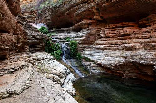
We decided to drop our heavy packs and just carry some water and cameras to the Royal Arch. Continuing down the drainage there was significantly more scrambling but now it was fun and easy without our heavy packs. We moved quickly and enjoyed a part of the canyon that seems very different from the rest of the canyon. Not far down this drainage there is bright green grass, purple budding trees, streams lined by plants, and large pools of water. This stretch of the hike was by far my favorite part of the hike due to the interesting terrain, unique scenery, and fun scrambles. Once we hit the Royal Arch we stopped to take pictures and look over the huge drop off on the other side of the Arch. Below this drop off downstream is Elves Chasm, our planned side hike for the next day. At this point it was 1530 and we decided we should get moving since we still had a ways to go and the rappel. We again made good time back to our packs and began the extremely steep ascent up onto the plateau.
![Stairs]() Brett and Brooke on the way to the Royal Arch
Brett and Brooke on the way to the Royal Arch![Royal Arch]() Me under the Royal Arch
Me under the Royal Arch![Stairs]() Stairs and pool on the way to the Royal Arch
Stairs and pool on the way to the Royal Arch![Pool]() Royal Arch pool
Royal Arch pool![Stairs]() Side canyon of Royal Arch
Side canyon of Royal Arch![Pool]() Royal Arch pool
Royal Arch poolAlmost There...
We gained hundreds in almost no time and the trail began to parallel the drainage along a narrow (in-places) ledge. Not only was the ledge narrow in places the expose was extreme. Just before the trail turns out onto the open plateau the ledge narrows to a few feet and there is a one foot gap you must step across. To your immediate left and looking down the gap you will see nothing but hundreds of feet of air. Once out into the open it was very hot even though it was getting late in the day. At this point we were tired and although we moved well we were surprised to find ourselves this late into the day with nearly two miles and the rappel still to go. We moved quickly across the plateau taking only one short break. We started descending off the plateau towards the river and quickly ran into a loose rocky scramble with some exposure. I decided I didn't feel comfortable downclimbing it with my pack so we dropped packs and I investigated. This section had two ledges and the top had tons of very small loose rock. Since none of us could get good enough footing on the loose rock to hand the packs down we decided to pull out the 7mm climbing cord I brought. Brett climbed down while I tied a figure-8 and attached a carabineer. I sat just above the loose rock and got a good stance with by feet. Next I tossed the carabineer to Brooke who would clip it into the pack and slide the pack down to me. I lowered the packs with a hip belay to Brett who took them off and brought the packs to the bottom ledge. The second pack knocked some loose rock down and although Brett took cover he still took a baseball sized rock to the knee. Once all the packs were down we downclimbed this section which was rather easy without the packs. Brett told us he saw a rope further down the ledge which meant we must be at the rappel. While the sun was behind the canyon walls it was still about 30 minutes before sunset which meant we had a little over an hour of light left.
The Rappel
We moved quickly to the rappel so I could see what we had to work with. Our plan was for me to get everything set up, have Brooke rappel down first, send all the bags down, then Brett, then I would go last. As Brooke started putting the harness on I took a look at the anchors that were already in place as well as the two ropes that were already there. There were about a half dozen pieces of webbing tied around a large section of rock with two large carbineers. The webbing was up under the rock, protected from the sun and a few pieces looked rather new so I decided to go ahead and use the pre-exsisting anchor. One of the two ropes had knots tied at intervals and was used for helping people climb up the cliff so we could not use it for a rappel. The other rope didn't look too bad but looked more like 8mm accessory cord than a climbing rope. Since I had my 11mm climbing rope I decided to take the smaller rope off and tie mine into the anchors. Once I had everything set up it Brooke stepped over and I got her on the rope. Since neither Brooke nor Brett had rappelled before it was going to be a quick lesson. After explaining how to do it and giving her a few tips she slowly started to back over the cliff. She did just fine and a few minutes later she was down. I lowered the 7mm accessory cord with carabineer on the end so I could pull the harness and belay device back up. We then proceeded as before; Brett clipped the bags into the cord and I would hip belay the bags down to Brooke. Once the bags were down it was Brett's turn for the rappel. As with Brooke we went over the details and a few minutes later he was safely on the ground. Now it was my turn; I pulled the harness on, doubled it back, coiled the cord that was still up there, got on the rope and headed down just about the same time as the sunset. Once down we had a few more minutes of light but at least we were done with the technical part. We hiked a short distance over a small hill and were able to look down a steep slope to the beach. The slope was steep and loose and since it was now dark we took turns negotiating down to the beach.
Toltec Beach
![Toltec Beach]() Our camp at Toltec Beach taken the next morning
Our camp at Toltec Beach taken the next morning
By 1930 we had made it to the beach where we found a few flat spots for our tents and set them up. While setting up my tent I took my last swallow of water. We were on trail much longer than expected and we needed to get water. All the tributaries in the area were dry which meant we needed to get water from the river. With all the silt in the river we had to use my 4 liter Platypus as a bear bucket which meant we were hours away from getting water. Brooke had about half a liter left so the three of us split that water then went to bed. It had been a long day and we were all tired and looking forward a day without carrying a full pack.
Mileage: 9mi
Net Gain: 700ft
Hiking Time: 11h
Pack Wgt: 50lbs
Day 3, March 28th: Elves Chasm
After a warm night I woke up fairly well rested and glad I wouldn't be wearing a full pack today. It was about an hour after sunrise and even though it was rest day we had things to get done plus we wanted to take the side hike to Elves Chasm. The water in the bear bucket was still a bit brown but there was a think layer of sand in the bottom. I pumped the water off the top and got about 3.5 liters from it, then refilled the bear bucket. Since it was dark when we got to camp Brett and I had just hung our bear bags off a boulder near our site. Brett found that a mouse had chewed through the bag and had chewed on the twist tie of the tortilla bag but had not actually eaten any food. I decided I would use the cord and webbing to make a better place for bear bags. Since there weren't any trees around I strung the cord and webbing between two rock formations that had a low area in the center. It certainly wasn't going to keep a bear out but it would keep the mice out. We ate breakfast and decided we would head down to Elves Chasm in the morning so we could take our time and it would give us time to relax at camp before sunset. We packed our lunches and brought all our empty water bottles and two water filters since the water there wouldn't require a bear bag it would allow us to fill up on water.
Hitchhiking
We began our hike to Elves Chasm in the late morning. We weren't sure where the trail started so we started hiking along the river and went up the slope when it became to difficult to stay along the river. This was slow going since we didn't really know the way and had to do some back-tracking in a few places. About 20 minutes after leaving I looked back to say something but a bright yellow raft caught my attention. We all turned to look at the rafts floating down the river towards us. As they neared us they yelled if we wanted a ride. We immediately shouted yes and I began running towards a large beach that stuck out into the river not far in front of us. The rower of the lead raft rowed into the beach and we hopped aboard. He confirmed we were headed to Elves Chasm which was their lunch-time destination. They were a group of 16 people from Oregon halfway through a three week rafting trip. Later I would find out the guy that picked us up was only 18 and it was already his second time rafting the Colorado. We were very thankful to not have to make the hike to Elves Chasm since we were still a bit tired from the previous two days. As we pulled out of the main current we jumped out and thanked them for the ride. We scrambled up to the main waterfall and pool that is Elves Chasm. We enjoyed the sites and talked with the rafters as they made their way up. Some of them even climbed around to the very top of the waterfall. We ate lunch while some of the went into the frigid pool. As they left we thanked them again and went to enjoy the pool ourselves. Brett and Brooke had intentions of swimming in the pool but it was way too cold. We hung around for a long time while I fiddled with my camera attempting to take HDR pictures with a makeshift rock tripod (it didn't work too well). After a few hours of enjoying the area we refilled all our water bottles from the pool and soon began hearing more voices. We decided to start the hike back since it was almost 1500 already. We talked for a short time with some of the next raft group on their way up. I began by carrying the pack with water but would only have to carry it a short ways since we had three of us and only one pack to carry. We found the trail we were supposed to arrive on and it was a few hundred feet up from the river. The trail was well marked and easy to follow but it was still a rough trail. My ankle was bothering me but was manageable and after a short time I passed the pack to Brett. We arrived back at the beach after 1.5 hours of hiking.
![Elves Chasm]() Me at Elves Chasm
Me at Elves Chasm![Waterfall]() Elves Chasm Waterfall
Elves Chasm WaterfallRest
Once back at the beach we pumped the bear bucket again and refilled the bear bucket. We then went down to the river and washed off some of the sweat from the past few days and enjoyed the warm sun. The water was cold enough to numb your feet in less than a minute but it felt good on sore feet. I sat on the beach with my ankle in the water in an attempt to make it feel better. I was a bit worried since our next day was 12 miles with over 1000ft of gain. After a while I went back and sat near my tent in the shade and enjoyed laying there on the warm sand watching lizards chase the bugs. The sun started to fade and we prepared our dinner while watching some bats swoop and dive for bugs.
Planning
Our next day would be a long 12 mile day to our final campsite below Tyndall Dome. There would be no drinkable water between here and the 5 1/2 gallons we had waiting in the car. The temperatures had been in the upper 70's and low 80's during the day so we would need to drink a lot during the hike. We all planned to use food that wouldn't require much, if any, water for our final night's dinner or breakfast the following morning. After filling up at Elves Chasm and emptying the bear bucket we had about 13 liters total. We knew we could get another 3 - 3.5 liters in the morning from the bear bucket but we really wanted more than that. After talking we decided we would pump the bear bucket now and again in the morning. The bear bucket had only had about four hours to settle but we had three filters so if one ended up clogging we would still be okay. Pumping the bear bucket was not a problem although my filter was just about done by the time we emptied it. After watching the stars and a spectacular full moon rise we went to bed agreeing to get up at 0600 so we could get some miles behind us before it got too hot.
Mileage: 2mi
Net Gain: 200ft
Hiking Time: 2h
Day 4, March 29th: Garnet and Copper Canyons
Brett woke me at 0600 and although the sun had not yet risen there was plenty of light. I got up and began organizing my gear so I could pack it properly this time. We pumped the bear bucket, broke down the bear bag line, and started packing up. While we were packing we cooked some breakfast. We took our time breaking camp and eating and by the time we were ready to hit the trail it was almost 0900. I'm not sure what took us so long but now it would cost us some water since it would be getting warmer sooner. We took inventory of our water supplies and we had just under 18 liters, nearly six liters per person. We were fairly confident that would be enough water.
Garnet Canyon
The hike started by climbing a few hundred feet above the river, then paralleling it until we hit the heart of Garnet Canyon. The trail was rough as usual but well marked. We shortly hit Garnet Canyon and began the climb up and out onto the Tonto plateau. There were a few steep loose sections then some scrambling section where we had to take our packs off and pass them up. The rock formations were very interesting and we enjoyed the scrambling. Leaving the rim of the canyon we saw a hawk close-by circling for food. Once on the Tonto plateau we continued following the trail and cairns along Garnet Canyon. It seemed that we were going in the wrong direction but we were still on trail. I remembered my map showed the Tonto trail continuing west and another trail going up Garnet Canyon and hitting a dead-end. We decided to start heading in the correct direction then look for the Tonto trail. After some more ups and downs we looked down and saw a trail. We checked the GPS and map and found we were looking at the Tonto trail not far from where we first topped out onto the Tonto plateau. Once on the Tonto trail we moved quickly although my ankle was hurting most the time. Out on the Tonto there is no shelter from the sun it gets very warm very quickly. Going in and out of side canyons we found a few boulders that provided a small amount of shade so we decided to stop here and get some lunch.
![Tonto Trail]() Along the Tonto trail
Along the Tonto trail![Hawk]() A hawk circles above Garnet Canyon
A hawk circles above Garnet CanyonCopper Canyon
After a short lunch we pressed on towards Copper Canyon. My map showed only two major canyons: Copper and Garnet. After coming out from a large side canyon and around a point we figured we had passed out of Copper Canyon and had only a few miles to the base of Tyndall Dome. We found some more shade so we rested for a while thinking we had made good time and were almost to our next camp. About 30-40 minutes into our rest I checked the GPS and found our assumptions we had made while looking at the map were very wrong. We had just finished going around a smaller side canyon and that we still had all of Copper Canyon to get around. We packed up, a bit annoyed at our poor assumption but motivated to get around this canyon. With eyes down at the trail we pressed on at a rather quick pace. A few hours later we came up a ridge to a point on the other side of Copper Canyon; we were now where we thought we were at our previous rest spot.
Below Tyndall Dome
After a short break we kept pushing through lots of ups and downs on a rough part of the trail. The sun began setting just as we neared some flat areas below Tyndall Dome. We weren't sure where we should camp for the night so we followed the trail as it turned towards the South Rim. Brett spotted three bighorn sheep just above us. I grabbed my camera as they spotted us and got a few pictures as they ran up and over the ridge. We decided to backtrack a few hundred feet to the flat spots we saw. I snapped a few pictures of the canyon and clouds at sunset. The pinks and purples only lasted about 10 minutes before dark descended upon us. We pitched our tents and pulled out some food. We took inventory of our water and we were in better shape than expected. We had enough for two liters per person for our hike the next day. We talked about our plans for the next day and we decided five hours was a reasonable time for us to make it to the rim. I pushed for an earlier start so it would be cooler so we would use less water. We decided on a 0530 wakeup and since breakfast would be cold it shouldn't take long for us to break camp and get on the trail. As the moon rose I got into bed and was asleep quickly after a very long and tough day.
![Sunset]() Sunset below Tyndall Dome
Sunset below Tyndall Dome![Sunset]() Sunset below Tyndall Dome
Sunset below Tyndall Dome![Bighorn]() Bighorn Sheep silhouetted below Tyndall Dome
Bighorn Sheep silhouetted below Tyndall Dome 12mi
Net Gain: 1400ft
Hiking Time: 11h
Pack Wgt: 55lbs
Day 5, March 30th: Run for the Rim
![Sunrise]() Sunrise below Tyndall Dome
Sunrise below Tyndall Dome
Brett woke me at 0530 and I reluctantly got out of my sleeping bag, pulled on some warmer clothes and started getting my gear packed. My ankle was quite swollen and it hurt to walk on it even without a pack. The skies were light enough to pack without a headlamp. Brett and Brooke ate some breakfast but I really didn't feel like eating although I knew I should. I decided I'd wait and just eat some food along the trail. I took a few pictures before the sun rose while the clouds were lit up and the canyon was still dark. We were on trail before sunrise and headed up towards the rim. I started off very slowly and was having difficulty walking due to my ankle. After about 30 minutes of stumbling and relying heavily on my trekking poles my ankle warmed up a bit I was moving with a bit more ease although I still had plenty of pain. The South Bass Trail crossed the bottom of the canyon and we began climbing up as we headed toward the rim. Once we hit the end of the lower part of the canyon it curved around and switchbacked steeply up. About 0930 we sat down to shed some layers since the sun now began to hit us. We ate some lunch and took stock of our water. The early start paid off, we all had about a liter left and had already made it halfway. Back on the trail again after lunch we hit the top of the first plateau at the base of Mt Huethawali and crossed the flat until we reached a familiar place, the junction 1.5 miles below the rim where we had headed off towards the Royal Arch drainage on the first day. I was having difficulty keeping up with Brett and Brooke due to my ankle so I gave Brett the car keys so they wouldn't have to wait for me to get the water that was waiting in the car. Our water situation was still looking good, 1.5 miles to go and we were all well hydrated with about 8-12 ounces left. Brett and Brooke started off and I trudged along behind them. With all the switchbacks I quickly lost sight of them but could still hear them occasionally. It was a beautiful day and although I was hurting I was enjoying the peacefulness. I began hitting some snow which I guessed was about 500ft below the rim. I had covered over 2500ft already! Pulling out my water bottle I swallowed the last of my water then continued on. There was a lot less snow than when we started but there were still significant drifts in some places. The last few hundred feet seemed to take forever but finally I caught a glimpse of the cars in the parking area. Brett and Brooke were already there drinking some water and changing into clean clothes. They said they had only been there 5 or 10 minutes so I had done well despite my ankle. I dropped my pack, stripped down to I could wash up and put clean clothes on. After a break we packed the car up and headed toward civilization and some REAL food.
Mileage: 6mi
Net Gain: 3200ft
Hiking Time: 5h
Pack Wgt: 45lbs
Conclusion
This was an extremely challenging route. I consider myself an experienced hiker and was prepared for a difficult route but it was significantly more difficult than expected. Anyone attempting this route should put lots of planning into their trip, be physically prepared, and have the necessary skills. There are dire consequences for not being prepared.
Tips and Recommendations (in totally random order):
Have something to use for a bear bucket
Bring a backup for EVERYTHING (water filter, batteries, etc)
Be able to repair along the trail (tent, backpack, etc)
Be very very very comfortable with exposed scrambling
Make sure your pack is well balanced - put the heavy stuff towards the bottom
Be comfortable carrying 50+ lbs all day long
Have a ton of water capacity for the last two days (we had about 18L for 3 people, more would have been nice)
Some people do this route in the opposite direction - I don't know how they did it and having seen it now I would never attempt it
Start early - you'll use less water and it will give you more daylight
Stay on trail - if you don't see an obvious trail or the next cairn, find it before you move. The cairns were well placed along the entire route
Be able to deal with medical issues - if I hadn't been able to hike on my ankle (or if something serious had happened) it would have been at least 2 days before anyone could be notified to even start a rescue attempt.
(Side note: I went to the docs two days after returning. Initially they thought the ankle was a stress fracture but it turned out to just be a bad case of tendonitis)
Comments
No comments posted yet.