Premise
I have been requested to split my previous Area page of Gran Paradiso Group because of its too big dimensions: consequently its consultation was difficult in particular for the SPers without fast connection to the net
Link to other Gran Paradiso pages
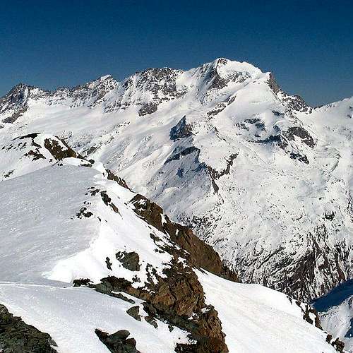
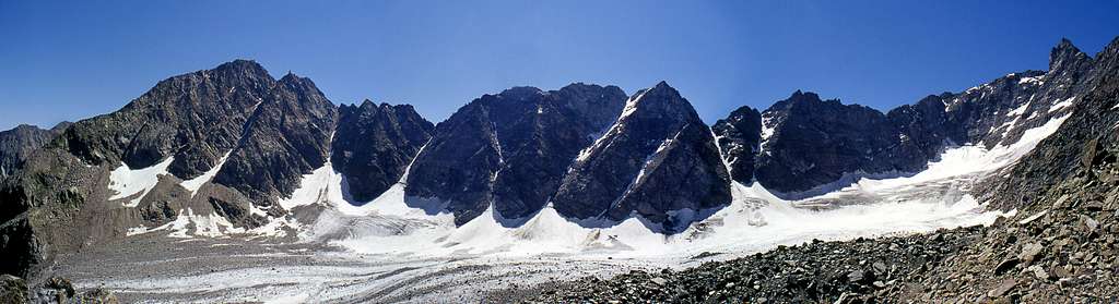
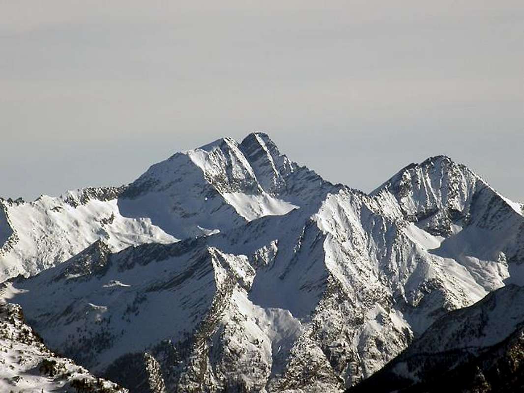
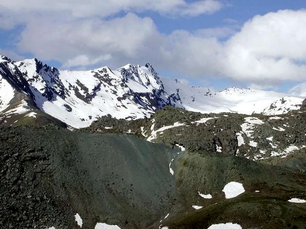
![The head of Valnontey from Gran Crou to Cresta Gastaldi]() The head of Valnontey from Gran Croux (left) to Cresta Gastaldi (right) The head of Valnontey from Gran Croux (left) to Cresta Gastaldi (right)
|
|
Moving SLOWLY the pointer of your mouse over each labelled summit, its name and height are shown.
Clicking on it, you will go the SP related page
![]() |
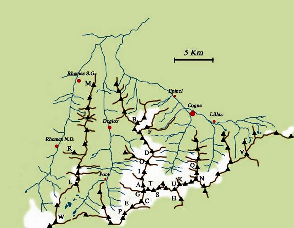
Getting there
Valle di Cogne - From Torino, Milano, etc: motorway A5. Exit at Aosta Ovest. Drive to the near Aymavilles. Follow the directions for Valle di Cogne.
- From Switzerland: through the Grand Saint Bernard Tunnel or the namesake Pass.
Drive to Aosta, then follow the direction for Courmayeur on SS.26. Just after Sarre, turn to the left, in the direction of Valle di Cogne.
- From France: through Mont Blanc Tunnel or Petit St. Bernard Pass. It isn't necessary to take motorway A5: you can drive on SS.26, in the direction of Aosta.Before arriving at the village of Sarre, turn right following the sign for Valle di Cogne.
After Aymavilles, the regional road n° 47 crosses the villages of Vieyes, Epinel and Cretaz and after about 25 Km arrives at Cogne (1534 m). From Cogne you can get the villages of Lillaz (1617 m) or Valnontey (1666 m).
Val di Rhemes and Valsavarenche - From France, through the Mont Blanc Tunnel or the Col du Petit Saint Bernard: you can drive on SS.26, following the direction for Aosta and, before arriving in Villeneuve, turn right towards Introd. Alternatively, you can take motorway A5 (at Courmayeur or Morgex) and exit at Aosta Ovest.
- From all other directions: get to the Aosta Ovest exit of motorway A5. Then drive along SS.26 Aosta, direction Courmayeur, and just after Villeneuve turn left towards Introd.
Shortly after Introd, you arrive at a junction: - you can go straight following the sign "Val di Rhêmes"and then drive through Rhêmes Saint Georges as far as Rhêmes Notre Dames; after the main village, Bruil (1723 m), the road reaches the hamlet of Pellaud, then becomes narrower and may be followed as far as the vast parking in view of Thumel (1880 m). From here the road follows but the transit is forbidden.
- or you can turn left, entering in Valsavarenche, and through many villages (Degioz, Eaux Rousses, etc) you can arrive at Pont (1978 m) where the road ends.
Southern valleys of the Gran Paradiso Group- Coming from Torino: motorway A5 towards Aosta - take exit "S. Giorgio Canavese" or follow the road SS n°460 towards Ceresole Reale as far as Pont Canavese (461 m)
- Going North along ValSoana, after Ronco Canavese (956 m) get to Valprato Soana (1113 m): at a fork, going NE takes you to Campiglia Soana (1350 m), while going NW takes you to the upper valley (Pianetto-Pamprato)
- Before Pont Canavese, turn left and go into the Valle di Forzo as far as the homonymous village (1180 m )
- after Pont Canavese, continue along the SS n° 460 until Locana (613 m): from here you can walk, entering Valle d'Eugio.
- After Locana, when you arrive at the village of Rosone (715 m), 16 km after Pont Canavese, take a small road on the right, following the sign "Piantonetto Valley": the road ends near Teleccio Lake(1870m).
- Following along the Valle dell'Orco, 10 km after Rosone you get to Noasca (1062 m): from here you can reach the Noaschetta valley that, after Alpe la Bruna (2473 m), divides into Vallone di Goi and Vallone del Gias della Luna, or Vallone di Ciamousseretto, where you can arrive more laboriously from the following Vallone del Roc.
- After Noasca, the road climbs along a gorge (Caporal and Sergent walls) and then arrives at the upper wide basin where, on the shore of an artificial lake, you meet Ceresole Reale (1613 m), 33 km after Pont Canavese. From Ceresole starts a controversial road that enter Gran Paradiso National Park and, after Serrù Lake and Agnel Lake, climbs up to Colle del Nivolet (2612 m). Luckily the old absurd project to continue the road on the other side, in order to connect with Pont (Valsavarenche) through the Piani del Nivolet, was stopped in time.
|
Summits of the Gran Paradiso GROUP
![]()
|
Summits of the Gran Paradiso GROUP reported in the previous map |
| 1_Punta Galisia 3346m |
28_Punta Rossa della Grivola 3630m |
| 2_Punta Basei 3338m |
29_La Grivola 3969m |
| 3_Punta Gran Vaudala 3272m |
30_Grivoletta 3514m |
| 4_Taou Blanc 3438m |
31_Gran Nomenon 3488m |
| 5_Aouillé 3440m |
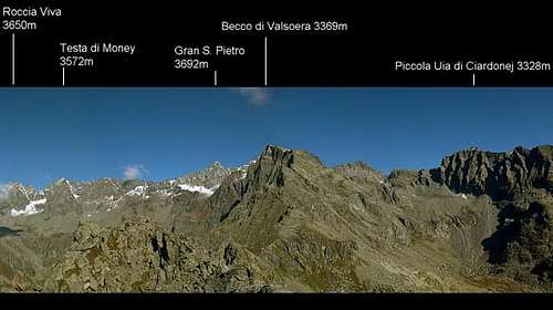
32_Mont Favret 3173m |
| 6_Cima di Entrelor 3430m |
33_Punta Valletta 2793m |
| 7_Punta Percià 3227m |
34_Becca Piana 2271m |
| 8_La Roletta 3384m |
35_Punta Ceresole 3777m |
| 9_Punta Bianca 3427m |
36_Testa della Tribolazione 3642m |
| 10_Punta Bioula 3414m |
37_Testa di Valnontey 3562m |
| 11_Punta del Ran 3272m |
38_Becca di Gay 3621m |
| 12_Punta Chamoussière 2942m |
39_Becco Meridionale della
Tribolazione 3360m |
| 13_Monte Paillasse 2414m |
40_Roccia Viva 3650m |
| 14_Cima dell'Arolley 2996m |
41_Torre del Gran San Pietro 3692m |
| 15_Cima di Seiva 3075m |
42_Punte Patri 3581m |
| 16_Punta Fourà 3411m |
43_Punta Valletta 3356m |
| 17_Mare Pércia 3385m |
44_ Punta di Valmiana 3244m |
| 18_Denti del Breuil 3454m |
45_Punta Fenilia 3053m |
| 19_Becca di Monciair 3544m |
46_Punta d'Ondezana 3452m |
| 20_Ciarforon 3642m |
47_Becco di Valsoera 3369m |
| 21_La Tresenta 3609m |
48_Punta delle Sengie 3408m |
| 22_Becca di Moncorvè 3875m |
49_Monveso di Forzo 3322m |
| 23_Gran Paradiso 4061m |
50_Grande Arolla 3246m |
| 24_Piccolo Paradiso 3923m |
51_Punta della Tsesère 3117m |
| 25_Becca di Montandayné 3838m |
52_Torre di Lavina 3308 m |
| 26_Herbetet 3778m |
53_Punta di Acque Rosse 2952m |
| 27_La Gran Serra 3552m |
54_Punta Nera 3064m |
|
Overview
|
In the Valle d'Aosta sector of Gran Paradiso, the three valleys of Cogne, Valsavarenche, Rhêmes are separated by mountain ranges, including the most imposing summits of the Gran Paradiso Group, directed mainly from South to North and all starting from a long West-East range.
The Piedmontese sector of Gran Paradiso includes a main valley running from East to West (Valle dell'Orco) and a series of secondary valleys, directed approximately northward: the hanging valleys ("valloni") of Ribordone, Soana, Campiglia, Forzo, Eugio, Piantonetto, Noaschetta, Gias della Losa, Goi, Ciamousseretto, Roc; all are separated by ridges less imposing than the ones in the Valle d'Aosta sector and starting from the long West-East range too.
|
West - East Main Ridge
The long West - East main ridge of Gran Paradiso Group can be divided in the following sectors:
a) Watershed VALLE di RHEMES - VAL d'ISERE: from Col di Rhême-Calabre to Punta Galisia
b) From PUNTA GALISIA to COLLE del NIVOLET
c) Watershed VALSAVARENCHE - VALLE dell'ORCO: from Colle del Nivolet to il Roc
d) Watershed VALNONTEY - VALLE dell'ORCO: from il Roc to Colle di Money
e) Watershed VALEILLE-VALLE dell'ORCO: from Colle di Money to Grande Arolla
f) Watershed VALLONE di BARDONEY-VALLE dell'ORCO: from Grande Arolla to Torre di Lavina
g) From TORRE di LAVINA to PUNTA NERA
h) From PUNTA NERA to PUNTA MISERINO
i) From PUNTA MISERINO to CIMA di PERADZA
j) From CIMA di PERADZA to ROSA dei BANCHI
a) Watershed VALLE di RHEMES - VAL d'ISERE
In this and following tables: black: summits; blue: passes; underscored bold: summits posted on SP (linked to their related page)
|
b) From PUNTA GALISIA to COLLE del NIVOLET
c) Watershed VALSAVARENCHE - VALLE dell'ORCO
| WEST-EAST RIDGE: c) Watershed VALSAVARENCHE - VALLE dell'ORCO |
|
![]() |
|
|
 |
|
|
 | |
|
 |
|
|
 |
In the past it was also named Colle del Gias di Beu: it connects Valsavarenche (Nivolet) with valle dell'Orco (Chiapili) |
- Colle di Punta Fourà 3124m
|
 |
 It is an unusual pass, since in practice connects three sides, Nivolet and Vallone di Seiva in Valsavarenche, and also valle dell'Orco (Gias di Beu) It is an unusual pass, since in practice connects three sides, Nivolet and Vallone di Seiva in Valsavarenche, and also valle dell'Orco (Gias di Beu) |
|

 |
A ridge starts northwards separating Piano del Nivolet and Vallone di Seiva:
-
 Colle di Seiva 3037 m
- Cima N. di Seiva 3075m
- Monte Giansana 3047m
- Gran Collet 2832m
-
 Cima dell'Arolley 2996m
|
|
![]()
![]() |
![]() In the past its slopes were almost completely covered with glaciers, now going to disappear
In the past its slopes were almost completely covered with glaciers, now going to disappear
![]() |
|
![]()
![]() |
 At the end of the South ridge of Mare Pércia, Colle della Terra 2911m separates it from the following Punta Rocchetta 2922m

|
- Colle Occidentale (W.)
del Grant Etret 3144m
|
![]() |
|
- Testa del Grant Etret
3201m
|
![]()
![]()
|
A ridge starts southwards:
- Colle della Porta 3002m
- La Cuccagna 3175m
- Colle di Courmaon 3077m
- Cima di Courmaon 3162m; and, beyond it, there are also:
- La Ciarma 2552m
- Colle Sià 2274m
- La Merola 2251m
 The southern rocky side of La Merola, otherwise grassy on the northern side, is named Parete di Balma Fiorant and consists of the famous walls: The southern rocky side of La Merola, otherwise grassy on the northern side, is named Parete di Balma Fiorant and consists of the famous walls:
El Sergent, El Caporal, Parete delle Aquile |
- Colle Orientale (E.)
del Grant Etret 3150 m
|
![]()
![]() |
|
- Denti del Broglio:
South 3454m /
Central 3420 m /
North 3390m
|
![]()
![]() |
|
- Colletto di Monciar 3297m
|
![]() |
|
|
![]() |
|
- Colle del Ciarforon 3317m
|
![]()
![]() |
|
|
![]() |
A ridge starts southwards:
La Torre 3225m Piccola Torre 3225mBocchetta 2820m; then the ridge turns eastwards:Cresta di Ciamousseretto 2837 / 2784 / 2706m Punta di Ciamousseretto 2488m |
| |
![]() |
|
|
![]()
![]() |
A ridge starts, directed mainly south-west:- Bocchetta 3228m
- Bocchetta di Goui 3139m
- Cresta dei Prosces 3223-3112-2912-2879m
- Bocchetta del Ges 2692m
- Becco dell'Alpetto 2801m
- Bocchetta dell'Alpetto 2570m
- Monte Castello 2612m
|
- Colle del Gran Paradiso 3345m
|
![]()
![]() |
|
|
![]() |
A ridge starts westwards, separating Gran Paradiso and Laveciau Glaciers, and terminates with Testa di Moncorvè 2964m |
- Colle della Becca di Moncorvè 3851m
|
![]() |
|
|
![]()
![]() |
|
|
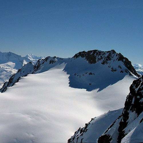
d) Watershed VALNONTEY - VALLE dell'ORCO_from il Roc to Colle di Money
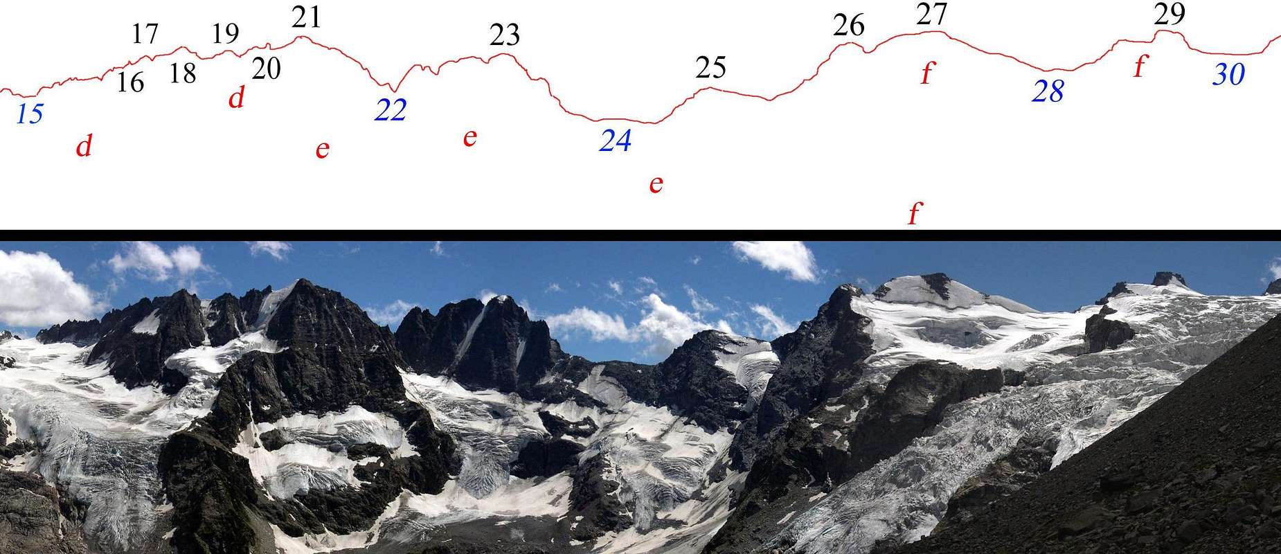
![]()
Identification of summits, passes and glaciers belonging to part of the watershed Valnontey-Valle dell'Orco.
View from Lucio and Lionello Leonessa fixed bivouac 2910m
|
Profile of the head of VALNONTEY |
SUMMITS and PASSES | GLACIERS |
| 15 - Colle di Money 3443m | d - Ghiacciaio di Money |
| 16 - Campanile di Money 3540m | e - Ghiacciaio del Gran Crou |
| 17 - Testa di Money 3572m | f - Ghiacciaio della Tribolazione |
| 18 - Becco della Pazienza 3606m | |
| 19 - Punta Elter 3603m | |
| 20 - I Gemelli 3610m / 3618m | |
| 21 - Roccia Viva 3650m | |
| 22 - Colle Baretti 3432m | |
| 23 - Becca di Gay 3621m | |
| 24 - Colle di Gran Crou 3315m | |
| 25 - Gran Crou 3437m | |
| 26 - Testa di Valnontey 3562m | |
| 27 - Testa della Tribolazione 3642m | |
| 28 - Colle della Luna 3542m | |
| 29 - Punta di Ceresole 3777m | |
| 30 - Colle Chamonin 3698m | |
| WEST-EAST RIDGE: d) Watershed VALNONTEY - VALLE dell'ORCO_from il Roc to Colle di Money |
|
![]()
![]() |
|
|
![]() |
|
|
![]()
![]() |
|
|
![]()
![]() |
|
|

 |
Its southern spur disappears under Noaschetta glacier, then reappears forming the not very prominent summit of Drei Vert 3202m |
| |
![]() |
|
- Testa della Tribolazione 3642m
|
![]()
![]() |
A short ridge goes South East: after Colle di Noaschetta 3490m it ends with Becca di Noaschetta 3525m, hanging over Lago di Gay 2968m |
| |

![]() |
|
|
![]()
![]() |
|
|
![]() |
|
|
![]()
![]() |
|
|
![]() |
|
| |
![]()
![]()
![]() |
- A short ridge, approximately southwards, divides the Ghiacciaio di Gay basin from vallone della Losa and ends with
Becco della Losa 3225m
![]() Starting from an intermediate point between Becca di Gay and Colle Baretti, an important ridge starts towards SSE.
It is characterized from the presence, after Colle della Losa 3129m, of the four summits of Becchi della Tribolazione:
Becco Settentrionale 3292m
Punta Pergameni 3300m
Becco Centrale 3316m
Becco Meridionale della Tribolazione 3360m. Starting from an intermediate point between Becca di Gay and Colle Baretti, an important ridge starts towards SSE.
It is characterized from the presence, after Colle della Losa 3129m, of the four summits of Becchi della Tribolazione:
Becco Settentrionale 3292m
Punta Pergameni 3300m
Becco Centrale 3316m
Becco Meridionale della Tribolazione 3360m.
-
![]() Here a secondary ridge starts eastwards, ending with Punta delle Carnere 2857m
Here a secondary ridge starts eastwards, ending with Punta delle Carnere 2857m
After Colle dei Becchi 2990m and Blanc Giuir 3222m, the main ridge follows southwards with Trasen Rosso 3060m, Bocchetta della Drosa 2675m , Gran Carro 2988m and Punta del Carro 2777m.
- A secondary ridge starting from
Blanc Giuir goes westwards, ending with Torri del Blanc Giuir 2724m. |
|
![]()
![]()
![]() |
|
|
![]()
![]() |
|
- Gemelli della Roccia Viva:
W. 3618m / E. 3610m
|
![]() |
|
|
![]() |
|
- Becco della Pazienza 3606m
|
![]() |
|
|
![]() |
A short ridge goes southwards, dividing the upper part of Roccia Viva glacier from Piano delle Agnelere:
- Bocchetta di Monte Nero 3278m
![]()
- Monte Nero 3422m
|
|
![]() |
|
|
e) Watershed VALEILLE-VALLE dell'ORCO_ from Colle di Money to Grande Arolla
f) Watershed VALLONE di BARDONEY-VALLE dell'ORCO
g) From TORRE di LAVINA to PUNTA NERA
h) From PUNTA NERA to PUNTA MISERINO
i) From PUNTA MISERINO to CIMA di PERADZA
j) From CIMA di PERADZA to ROSA dei BANCHI


 19910 Hits
 90.13% Score
 31 Votes
 The head of Valnontey from Gran Croux (left) to Cresta Gastaldi (right)