


-
 3751 Hits
-
 81.18% Score
-
 13 Votes
|
|
Area/Range |
|---|---|
|
|
45.55530°N / 7.44859°E |
|
|
Hiking, Mountaineering, Trad Climbing |
|
|
Spring, Summer, Fall, Winter |
|
|
10853 ft / 3308 m |
|
|
Note
La montagna chiama i suoi figli, ed essi rispondono fedelmente al suo appello… Osvaldo Cardellina, Diario alpinistico, 1964-65 Page texts: @ OsvaldoCardellina "Osva", passed away on May 2, 2022. Page owners: Christian Cardellina e Osvaldo Cardellina. Any updates from September 12, 2022: Antonio Giani, page administrator, friend and climbing companion. Testi della pagina: @ OsvaldoCardellina "Osva", scomparso il 2 maggio 2022. Proprietari pagina: Christian Cardellina e Osvaldo Cardellina. Eventuali aggiornamenti dal 12 settembre 2022: Antonio Giani, amministratore della pagina, amico e compagno di salite. |
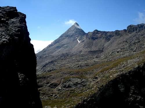
Bardoney Overview
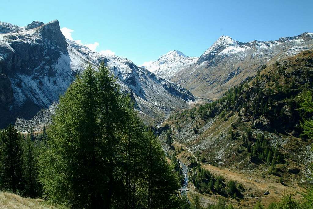
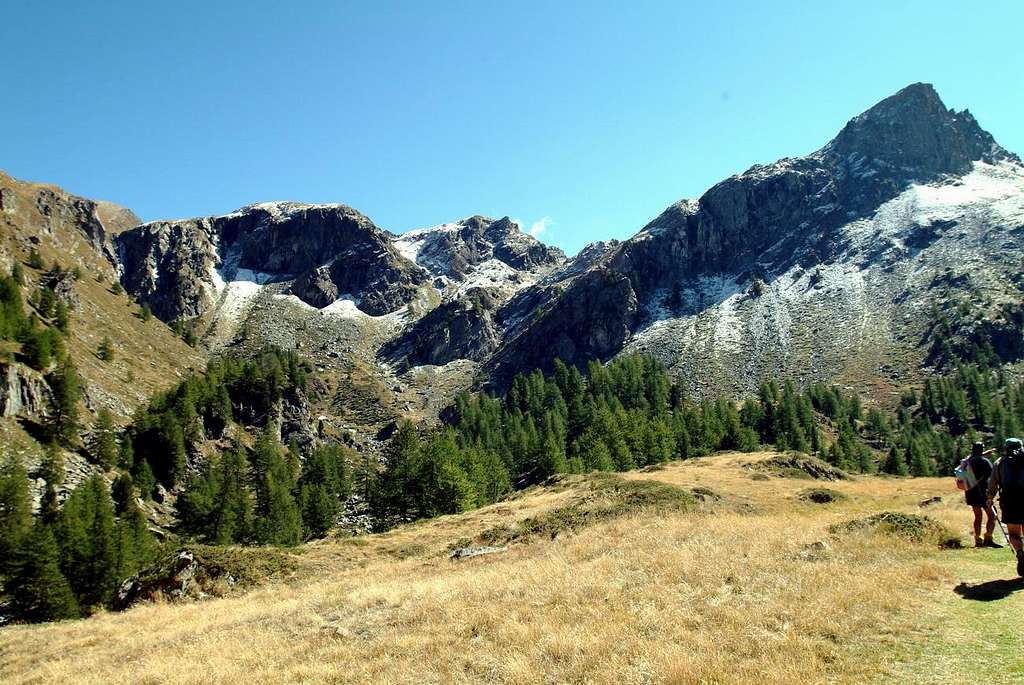
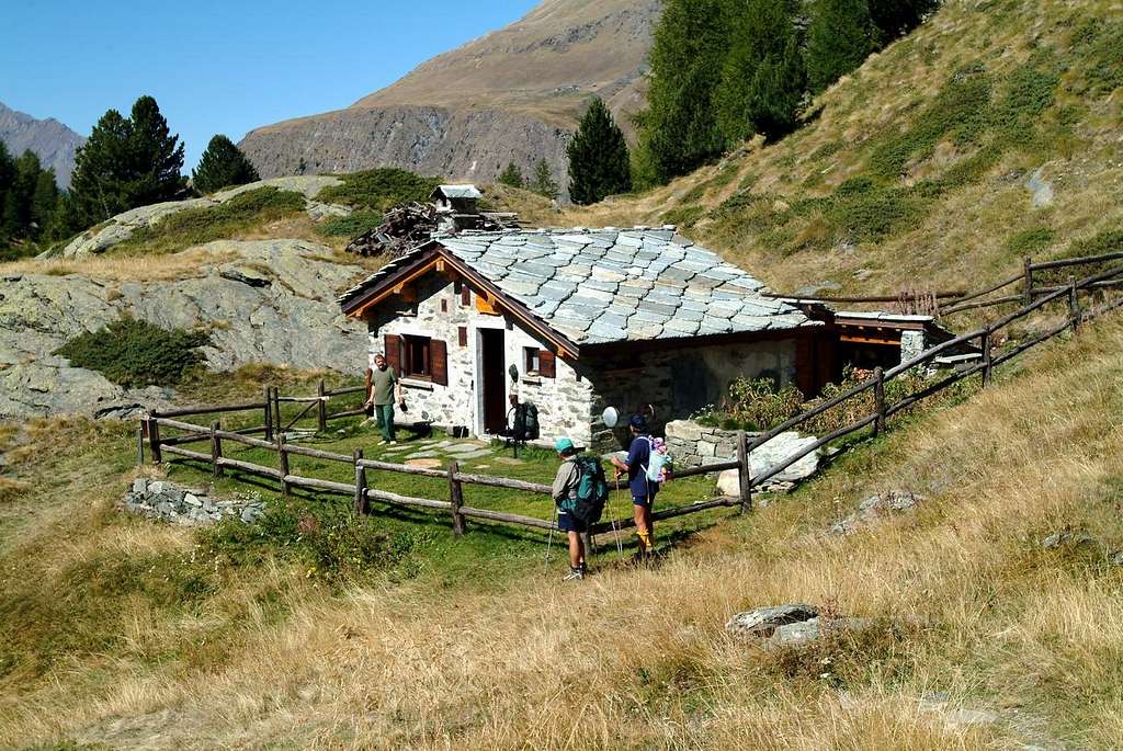
A little known vallon, almost forgotten. Not many people attending the Vallon Bardoney, except that the initial part, diverting to South High Route n° 2, goes to the Casotto P.N.G.P. then reach the Alp Bardoney to about a third of the development of the same. Many reached the Plan des Goilles, immediately below the Cabin, they turn to their right and reach the beautiful Lake of Loie or Loee; an easy descent, also in the Northwest, leading them back to Lillaz closing a wonderful hiking tour. In addition, the paths is no longer suited to this practice. Yes, there is still that the crossing via the Col Arolla, passing under the South Ridge of Punta Tsesère, reaches into the other side of the Alp Valeille; but is the only one. On the East, towards the small Tops of Acque Rosse and to the Tower of Lavina, small vallons descend steep and rough, most turned to goats than men, they do not offer paths. On the Western side, before the Col Arolla, vallons abandoned by God and men reach the Summits of Loie, Bardoney and Rossin. Not finding trails on site, no one is wrong. Or almost. Later the speech becomes purely mountaineering is that, after a tiny pond, you want to reach the Bardoney Pass to fall Bivouac Davito in Canavese, whether you want to reach the remains of the Glacier Lavinetta. In the first case you can go to the Tower Lavina by Normal, or from the same hill climb through the beautiful and rugged Ridge Southwest. In the second, leaning to the West, you can reach more than wild Col des Murailles Rouges, placed between the South Crest of the Grande Arolla and Punta of Forzo. By the same, in a short time, you can reach both Summit. But the path, especially in the lower part, is very exposed to falling rocks and recent Maps report it conspicuously in red. If you are not climbers, stop Bardoney, or take the Tour of Lake Loie. If you are an expert hikers cross the Col Arolla and go down Valeille. If you are neither the one nor the other went to find the Ranger with his German shepherd dog to Cabin. While if from Lillaz Hamlet you got this far, you have been good. It just ...
 |
 |
Un vallone poco frequentato, quasi dimenticato. Non sono in molti che frequentano il Vallone del Bardoney, tranne la parte iniziale che, deviando verso Meridione dall'Alta Via n° 2, si porta al Casotto del P.N.G.P. per poi raggiungere l'Alpe del Bardoney a circa un terzo dello sviluppo del medesimo. Molti arrivati al Plan des Goilles, subito appresso al Casotto, giran sulla loro destra e raggiungono il bel Lago delle Loie o di Loee; una facile discesa, sempre a Nordovest, li conduce nuovamente a Lillaz chiudendo uno splendido giro escursionistico. Oltre, non é più sentiero particolarmente adatto a questa pratica. Si, esiste ancora la traversata che tramite il Colle di Arolla, passando sotto la Cresta Sud della Punta delle Tsesère, raggiunge dall'altra parte l'Alpe di Valeille; ma é l'unica. Dalla parte Est, verso le Punte di Acque Rosse e fino alla Torre di Lavina, scendon valloncelli dirupati e selvatici, più rivolti alle capre che agli uomini, e non offerenti sentieri. Sul lato Occidentale, prima del Colle d'Arolla, valloni abbandonati da Dio e dagli uomini raggiungono le Sommità delle Loie, di Bardoney e del Rossin; non trovando in loco sentieri, non ci và nessuno. O quasi. Più avanti il discorso diventa prettamente alpinistico sia che, dopo un laghetto, si voglia raggiungere il Colle di Bardoney per scendere al Bivacco Davito in Canavese, sia che si voglia raggiungere i resti del Ghiacciaio di Lavinetta. Nel primo caso si può andare alla Torre di Lavina per la Via Normale, oppure dal colle medesimo salire tramite la bella e frastagliata Cresta Sudovest. Nel secondo, appoggiando ad Ovest, si può raggiungere il più che selvaggio Col des Murailles Rouges, posto tra la Cresta Sud della Grande Arolla e la Punta di Forzo. Dallo stesso, in breve tempo, si possono raggiungere entrambe le Sommità. Ma il percorso, soprattutto nella parte bassa, é molto esposto alla caduta di pietre e le recenti Carte lo segnalan vistosamente in color rosso. Se non siete alpinisti, fermatevi all'Alpe del Bardoney, oppur fate il Giro del Lago delle Loie. Se siete degli Escursionisti Esperti attraversate il Colle di Arolla e scendete in Valeille. Se non siete né l'uno né l'altro andate a trovare il Guardiaparco col suo cane pastore tedesco al Casotto. Se dalla Frazione Lillaz siete arrivati fin qui, siete già stati bravi. E basta ...
 |
 |
 |
 |
 |
Getting There
BY CAR:
- From TORINO, MILANO, etc: Motorway A5. Exit at IVREA or Quincinetto (PIEDMONT) AOSTA West/Aymavilles, Cogne Municipalities.
- From Aymavilles (646m) towards Cogne Valley: Vieyes (1.158m) near Sylvenoire Village (1.331m), Epinel and Crétaz Hamlets until Cogne (1.534m); through Main Road. From Lillaz Fraction (1.607m), reached by Cogne (7,5 Km.) to "Sogno di Berdzé" Refuge, below Fenêtre Champorcher, by dirt road, muletrack or paths in Urtier Vallon.
- From FRANCE: through the Mont Blanc Tunnel to Entrèves-crossroads to Vény/Ferret Valleys - Mountain Guides of Courmayeur - La Saxe Rock Gym - Courmayeur. By Little Saint Bernard Hill, closed since November until half May to La Thuile Valley - Pré Saint Didier - Courmayeur. It is not necessary to take Motorway A5: you can drive on SS.26, in the direction of AOSTA - IVREA - TURIN.
BY PLANE:
- Aeroporto "Corrado Gex" Saint Christophe (Aosta).
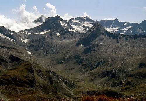
Vallons important & recommended Excursions
The Vallons most important & the recommended Excursions (10)
2) - Casotto Gran Paradiso P.N.G.P., Loee or Loie Loch (2.156m, 2.346m): Excursion with trail n° 13/13G in South to Cabin National Park; from this with path n° 12/TVC to the West, bypassing Plan de Goilles, towards the Loie Lake (2.346m), below Cime-de-Bardoney and Pointe de Loie (2.709m, 2.674m) (E/F; 2h'30/2h'45 by Lillaz Village).
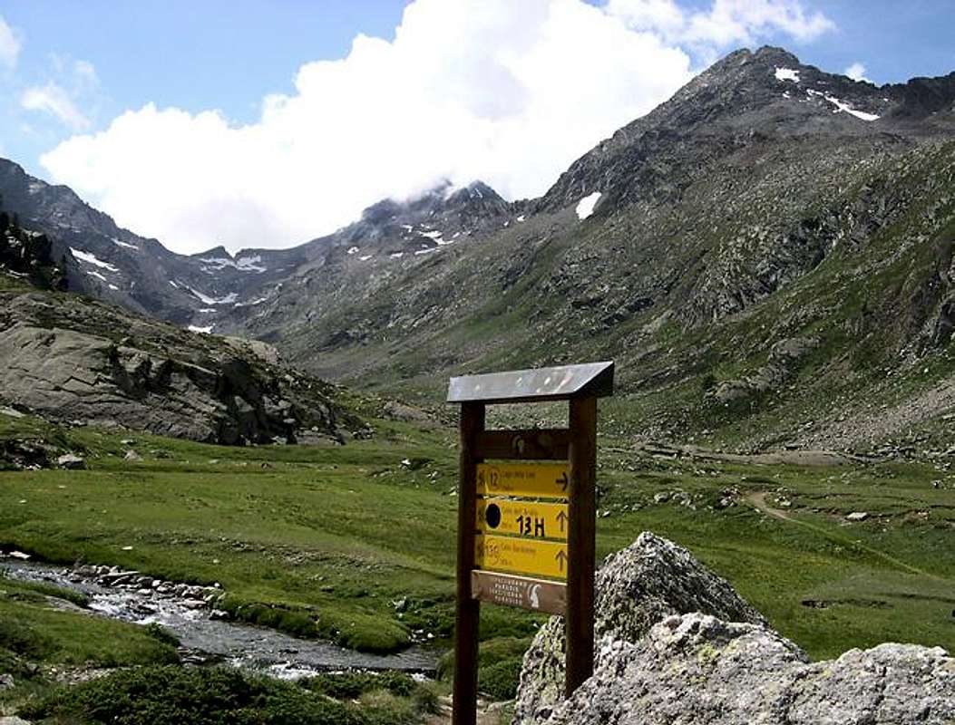
3) - From Lillaz or by "Sogno di Berdzé" Refuge towards Casotto P.N.G.P., Bardoney Alp (2.156m, 2.345m): Excursion with trail n° 13/13G in Southeast or in West from shelter to Cabin Gran Paradiso National Park and subsequent Bardoney Alp. This with path n° 13H in West to Northern Arolla Pass (2.915m), between South Crest of Punta delle Tsesère and Southern Arolla-Petite Arolla Passes and Summits of Petite and Grande Arolla in watershed with adjacent West Valeille (3.234m, 3.243m; EE/F; 2h'45/3h'15).
4) - Northern Arolla Pass and Punta delle Tsèsere or Chésère also Cesera: Excursion-Climbing through path n° 13H and by Southern Ridge to South Ante Top (3.033m) (with some bypass in the West under the edge of South Crest in the final part) and Summit of Punta delle Tsesère also called Punta Cesera. Also, with few visitors away, some small circumventions in West in initial part up to the connection with Eastern Crest, pathless but through grassy slopes mixed with small rocks (EE/F+; 1h'00/1h'15 from hill).
5/6/7) - Bardoney Alp Murailles Rouges Pass (3.187m): Excursion-Climbing with trail n° 13G in South to Glacier Lavinetta. This pathless in West to Murailles Rouges Pass, between South Crest Grande Arolla (3.238m) and North-northwestern Crest Punta di Forzo (3.298m) (A/F+; 3h'45/4h'15; an hour and a half more, crossing both Summits).
 |
 |
 |
 |
 |
8) - Bardoney Alp towards Bardoney Pass: Excursion pathless in South from Glacier de la Lavinetta to Bardoney Pass (2.833m; to Southeast Davito Bivouac), between Southwest Ridge of Torre di Lavina (3.308m), Col des Murailles Rouges (3.187m) and East-northeast Crest Punta di Forzo (3.298m) (EE/F; 2h'15/2h'30 from Alp Bardoney).
9) - Bardoney Pass: Climbing in Northeast from Pass through Southwest Ridge of Southern Torre di Lavina (3.308m), crossing La Tourelle (2.939m), Tourelle Pass, Lavinetta (3.012m), Lavina Pass (A/PD+/AD; 6h'30/7h'00; time and difficulty vary widely depending on the via followed, with different possibilities of circumvention on West Wall).
10) - Côte Torsa Vallon until three Lavina's Towers: Climbing in East from Bardoney Tableland in fork 2.216 meters into valley floor; without path crossing Bardoney Torrent to small glacier. After through West Slope towards Northern Ante Top (3.206m) and traverse to North Summit (3.277m), by North Ridge. After with short descent to carving 3.245 meters and North Crest of Lavina Southern Tower (3.308m) the highest of entire vallon (A/PD-/PD; 2h'30/3h'00 from Bardoney Alpage; 5h'30/6h'30 from Lillaz Hamlet).
 |
 |
 |
Red Tape
Within the borders of the P.N.G.P. (Parco Nazionale del Gran Paradiso), at the moment (summer 2004), dogs generally are not allowed, except on a couple of trails, and camping is forbidden (except for climbers from sunset till dawn). No fees are due.
Campings
- Wild camping in the Parco Nazionale del Gran Paradiso is strictly forbidden!!!
Mountain Condition
- You can get meteo information at the official site of the Regione Valle d'Aosta:
- Valle d'Aosta Meteo
Webcam
- WEBCAM on Aosta Valley:
- Webcam

|
Books and Maps
BOOKS:
- "Guida delle Alpi Occidentali" di Giovanni Bobba e Luigi Vaccarone C.A.I. Sezione di Torino Volume II (parte II), 25 Maggio 1896.
- "Rifugi e bivacchi in Valle d'Aosta" di Cosimo Zappelli aggiornata da Pietro Giglio. Musumeci Editore, Luglio 2002.
- "Il Parco Nazionale del Gran Paradiso (Valli di Champorcher-Clavalitè-Saint Marcel-Laures-Cogne-Valsavarenche-Conca di Pila" di Giulio Berruto 3/volume 2°, IGC, Torino 1981, 2a Ed. 2000. (in Italian)
- "Guida dei Monti d'Italia-Gran Paradiso Parco Nazionale" E. Andreis, R. Chabod, M. C. Santis, Club Alpino Italiano/Touring Club Italiano, prima Ed. 1939; seconda Ed. 1963; terza Ed. 1980.
- "Gran Paradiso", A. Gegenfurtner, G. Klotz, F. Müller, Ed. Bergverlag Rudolf Rother, Monaco 1980 (in tedesco).
- "Gran Paradiso", di Pierandrea Mantovani e Renato Misischi, Ed. Rassegna Alpina, 1974.
 |
 |
 |
 |
MAPS:
- Kompass "Gran Paradiso Valle d'Aosta Sentieri e rifugi" Carta turistica 1:50.000.
- L'Escursionista "Tour de la Vallée de Cogne Grand Paradis" Carta dei sentieri 1:25.000.
- I.G.C. Istituto Geografico Centrale "Gran Paradiso-La Grivola-Cogne" Carta turistica 1:25.000.
- I.G.M. Istituto Geografico Militare Foglio 41 1:25000: I SO Gran Paradiso - I NE Cogne.
- A.IA.T "Cogne Gran Paradiso Cogne Aymavilles-Walking map" 1:25.000.
- L'Escursionista "Valle di Cogne" Carta dei sentieri (n°10) 1:25.000.
Important Information
- REGIONE AUTONOMA VALLE D'AOSTA the official site.
- FONDAZIONE MONTAGNA SICURA Villa Cameron, località Villard de la Palud n° 1 Courmayeur (AO) Tel: 39 0165 897602 - Fax: 39 0165 897647.
- SOCIETA' GUIDE ALPINE DI COGNE Tel. 347/9473526 – 328/1373728.
- A.I.NE.VA. (Associazione Interregionale Neve e Valanghe).
- A.IA.T. Cogne Gran Paradis via Bourgeois n° 34 Tel. 0165-74040. E-mail: aiat@cogne.org
- Ezio Sport articoli sportivi - via Bourgeois n° 64 Tel. 0165-74204.
Useful Numbers
- Soccorso Alpino Cogne (SAR) Tel. 3482685406.
- Protezione Civile Valdostana località Aeroporto n° 7/A Saint Christophe (Ao) Tel. 0165-238222.
- Bollettino Meteo (weather info) Tel. 0165-44113.
- Unità Operativa di Soccorso Sanitario Tel. 118.