
-
 6513 Hits
-
 77.48% Score
-
 8 Votes
|
|
Route |
|---|---|
|
|
42.26440°N / 123.8223°W |
|
|
Hiking |
|
|
Spring, Summer, Fall |
|
|
Half a day |
|
|
Trail hike |
|
|
Getting There
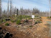

Zero your odometer here and start heading west on this paved road. At 1.0 the pavement narrows, at 2.7 cross the famous green steel bridge over the Illinois River. This green bridge has been the sight of many logging protests and some violence. At 3.1 the pavement ends at the Josephine Campground. At 3.7 stay right and then just stay on the good main road for several miles as it climbs up over 4,000 ft. At 14.3 go right and ignore several spur roads that branch off the main road. At 14.9 miles arrive at the Onion Camp trailhead on the left. There is a nice new vault toilet at the trailhead.
Route Description
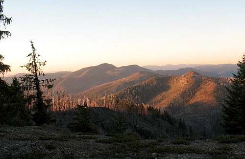
The trail heads west and Eagle Mountain is north. You will be able to see Whetstone Butte in front of Eagle Mountain which is in the background behind Whetstone Butte and in front of Pearsoll Peak. The trail is part of the longer Kalmiopsis Rim Trail that stretches for 28 miles on the east side of the wilderness and is accessible from several trailheads.

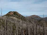
In about .5 mile the trail climbs up to a ridgeline and turns to the north towards Whetstone Butte and Eagle Mountain. The trail follows this ridgeline directly at Whetstone Butte for another .5 mile. If you want to climb Whetstone Butte, notice when the trail turns left and starts descending to the west side of Whetstone Butte. Leave the trail here make your way up and to the east side of the butte. The south side of the butte that you have been walking towards is rocky and steep. The east side of the butte is an easy scramble up to the summit and you gain about 160 ft above the Kalmiopsis Rim Trail. If you climb Whetstone Butte, come back to the trail the same way you went up, otherwise, it is a long cross country brushy scramble to Eagle Gap.
Once back on the trail after scrambling up Whetstone Butte, continue north on the Kalmiopsis Rim Trail. The trail loses over 500 ft of elevation as it passes on the west side of Whetstone Butte and down to Eagle Gap. Eagle Gap is a pass on the ridge between Eagle Mountain and Whetstone Butte. Near Eagle Gap you emerge from the burned forest that covers the west side of Whetstone Butte and you can see some nice pine trees up on the ridge leading up to Eagle Mountain.
The trail switchbacks a few times and climbs up to the ridge and the pine trees. Stay on the trail as it leads directly towards Eagle Mountain. The trail raches the summit area of Eagle Mountain but doesn’t go directly over the summit. Before the trail starts to descend on the north side of Eagle Mountain leave the trail and head west out to the rocky highpoint of Eagle Mountain. It is only a couple hundred feet out to the highpoint with little brush and no obstacles. Total hike including go to the summit of Whetstone Butte is 5.75 miles, gains 1,880 ft, and took less than 3 hours. If you are inclined to continue on to Pearsoll Peak, it is about another 5 miles each way to that summit and it will add another 1,800 ft of elevation gain to your hike.