
-
 12679 Hits
-
 91.14% Score
-
 34 Votes
|
|
Route |
|---|---|
|
|
38.54477°N / 107.68872°W |
|
|
Scrambling |
|
|
Spring, Summer, Fall |
|
|
Half a day |
|
|
Class 3 |
|
|
Overview

There are three major South Rim Routes to the bottom of the Black Canyon of the Gunnison:
1. Gunnison Route - is the most popular one. This route starts right next to the visitor center.
2. Tomichi Route - is the steepest one.
3. Warner Route - is the longest one.
You need to obtain a back country permit for all inner canyon hikes
Although the Tomichi Route is difficult over its entire length because of loose rock and full exposure to the sun, fishermen find this entry point attractive, as it gives access to long stretches of the river during low water.
Camping is not as good as on Gunnison Route. I wandered along the Gunnison river for 40 min, and had a hard time finding nice flat spots for pitching up tents (one spot was very muddy - it was raining the day before), and the other one had very overgrown grass, and boulders around. I would prefer camping on the bottom of the Gunnison route.
The hiking times are from the little booklet available for free at the visitor center. This booklet describes all inner canyon hikes, and gives these times. I did all hikes much faster, e.g. Tomichi Route took about 50 min down, and about 1 hr 10 min up. And I considered it a slow moving pace since the trail was muddy and rocky sections were very wet.
Getting There
The entrance to the Park is located 6 miles north of the junction of US-50 and CO-347. To reach this junction from Montrose, travel 9 miles east of town on US-50, or from Gunnison, drive 56 miles west of US-50. CO-347 turns into South Rim Drive and is the most popular access to the Park. The paved access road and the Visitor Center are open year round.The route starts either from the South Rim Campground or from the Tomichi Point Overlook on the South Rim Road.
 |  Black Canyon as seen from the Rim Rock Trail on rainy October morning Black Canyon as seen from the Rim Rock Trail on rainy October morning |
Route Description


To begin from the campground, pick up the Rim Rock Trail guide at the start of the trail. Hike on this nice trail, and you can stop at several overlooks into the canyon. You will see a smaller trail turning off at the #13 station. The route begins here and descends steeply into the canyon. You can also access the Rim Rock Trail from the Tomichi Point Overlook area (see the illustration above).
Take care to avoid knocking large rocks on hikers below (I guess in the summer you may meet other people on the trail. I did not meet anyone).
Hikers can choose alternate routes to descend or ascend, since all the routes converge into one draw leading to the river. Follow the main drainage down the very loose, talus covered slope to the river. There are occasional small cairns along the route. Route finding was not difficult.
Essential Gear


Good hiking boots (low hiking shoes will get a lot of pebbles in, consider low gaiters).
This route is exposed to the sun, so bring a lot of water in the summer.
You will have to use you hands, so trekking poles are not very helpful.
You are required to obtain a backcountry permit for this route. The permits are available at the visitor center. You can also fill the paperwork and drop it at the box just outside the visitor center if you are planning to start your hike very early. The visitor center opens around 8 AM. For more information see the Gunnison route description.
Views along the route
 |  |  |  |  |  |
 |  |  |  |  |  |
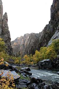
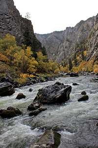
Along Gunnison River
The Gunnison River is a tributary of the Colorado River, approximately 180 miles (290 km) long. It it formed by the confluence of Taylor and East rivers. Just past the town of Gunnison, the river begins to swell into the expanse of Blue Mesa Reservoir, a 36 mile (58 km) long reservoir. Just downstream it is dammed again to form Morrow Point Reservoir, and another Crystal Reservoir. The reservoirs are the upper part of the Black Canyon of the Gunnison, one of the longest, narrowest and deepest gorges in the world. There are multiple cataracts through the Black Canyon. At the outlet of the canyon it receives the North Fork River, then near Delta (Colorado town) is joined by the Uncompahgre River. It then winds through desert canyonlands until it empties into the Colorado River near Grand Junction. | 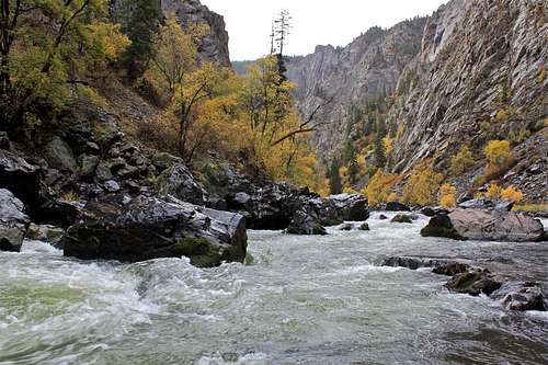 |
 |  |  |  |
 |  |
Weather


External Links
National park infoInfo about inner canyon routes from The American Southwest
If you are lucky you may encounter a bear
I was not lucky, and encountered this