
-
 6174 Hits
-
 81.18% Score
-
 13 Votes
|
|
Route |
|---|---|
|
|
Bouldering, Scrambling |
|
|
Spring, Summer, Fall |
|
|
Half a day |
|
|
Overview
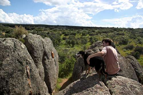
Nice view from Boulder C.
from our parked car.
The approach time is less than 5 min. The area is very small - I expected it much bigger, basically only 4 big boulders - A,B,C, and D. You can ask for a free guide with route description at the visitor center. The rating is not the usual bouldering rating, but it is rated as easy, moderate, difficult and very difficult. The routes are from 10 to 20 feet high off the ground, the landings are almost always clear and level.
For such a small area, the rocks offer a surprising number of quality routes. The rock is generally very solid but rough. Consider bringing a tape. Some routes have cracks and when jamming hands you can scrape your skin off nicely. Easy routes tend to follow good crack systems while the harder ones are usually steep to overhanging faces. It takes a while to get one's fingers accustomed to the tiny and often sharp holds.
I don't think that many people boulder there. The path was overgrown, and many routes had bushes right next to the route. Very little chalk marks seen. It is a small place, and worth to check it out if you are visiting Black Canyon, but not a major bouldering destination. It is friendly for children - little passages between boulders provide a perfect hide and seek place, and it is far from the canyon rim, so you don't have to worry about them falling into the Black.![Marmot Bouldering, Black Canyon of the Gunnison]()
This is the diagram that the NPS provides for bouldering at Marmot Rocks, Black Canyon of the Gunnison National Park, CO. ![scenic drive along the rim of the canyon]()
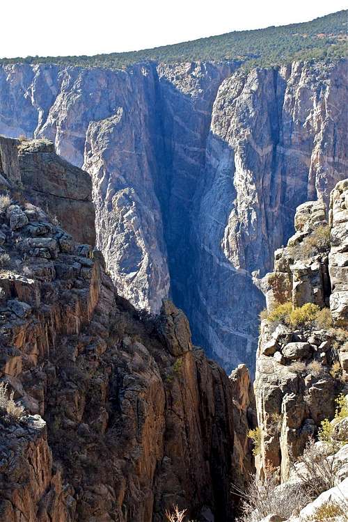
Scenery along the South Rim
Black Canyon of the Gunnison National Park is located approximately 250 miles southwest of Denver.
South Rim: 15 miles east of Montrose, via U.S. Highway 50 and CO Highway 347, the turn off for Highway 347 and Black Canyon is well signed.
PUBLIC TRANSPORTATION - no recommended
By bus: To Montrose or Grand Junction (This option requires a lot of waiting for connecting buses at Greyhound stations. Not recommended).
By train: To Grand Junction only (There is a train between Denver and Grand Junction)
There is no public transportation within the park, or from Montrose to the park.
PLANE
Commercial airline service is available to Montrose, Gunnison and Grand Junction. You can rent a car at the airport.![What to do now?]()
Corridor between Paint Bucket and Linquin Block![keep going, baby]()
My son's turn![Boulder A]()
Ivory Block![Almost at the top]()
Serpentine Block SplitterMarmot Rocks are located along the South Rim Drive, and on the top of the canyon. You do not need backcountry permit to access and boulder here.
The bouldering area is near the Painted Wall Overlook. There are four solid granite blocks with cracks, steep faces, and slab problems.
How to find these boulders? From the entrance station, drive west for 5.2 miles on South Rim Drive road and park at the Painted Wall Overlook. From the parking area, hike 175 yards west up the road, past a curve in the road. There is a small unmarked trail, follow it for about 150 feet to the granite blocks.
You can pick up a free description handout about Marmot Rocks bouldering at the Visitor Center.
The park handout does not describe names of the boulders, and names those A, B, C, and D. However A Falcon Gude to BOULDERING COLORADO names these boulders . I know this is confusing! I usually follow just the park's free handout. I would not have even considered comparing the route descriptions, only when writing this for SP, I noticed the difference. Anyway, park handout has slightly more routes, and the boulders are very easy to identify from both descriptions.
Ivory Block - this is the first block you will see on the left as you approach. This would be Boulder A per park handout. It is the second largest of the four, yet it is wider than the larger Serpentine Block. The Falcon Guide to Bouldering has 6 routes described ranging from V0 to V3. It is easy to scramble down from the top of this boulder. The free park handout describes 11 routes, and as the descent it recommends to jump from this boulder to Paint Bucket Block (= Boulder B) and there is a descent path on the north side of this boulder.
1. Tan Line V3 Climb up just left of the center of the north face, utilizing the white holds.
2. Ivory V3 Climb up the lengthy center of the north face, utilizing layways.
3. Neon V2 Climb up the leaning flake on the far-right side of the north face.
4 .Fluorescent Climb up the northwest arete
5. Light Crack V0 Climb up the right hand crack, on the left side of the south face.
6. Lightning V2 Climb up the face just right of the right crack on the south face.
Paint Bucket Block - this corridor-forming block is just left (east) of Ivory Block It has 4 routes ranging from V0 to V3. The park handout calls it Boulder B, and describes 7 routes.
1. Brush V0 Climb up the slab on the left side of the northwest face.
2. Easel V1 Climb up the northwest prow up and right from the horizontal break down low.
3. Oils V2Climb up the southwest arete from the south face.
4. Acrylic V3 Climb up the crack on the left side of the east arete.
Linquin Block This is the left most of three in a line, just east of Paint Bucket Block and forming another corridor between the two. It has two described routes: V1 and V2. Park handout calls it Boulder C, and describes 4 routes on it.
1. Canvas V1 Climbs up the small holds on the left side of the west face.
2. Gesso V2 Climbs up the southwestern prow moving left up top.
Serpentine Block This is the largest, elongated block with a letter V formed by two cracks on its north face. Good problems abound on this choice granite. It has 9 described routes from V0 to V3. This would be Boulder D per park's handout, and they describe 14 routes. This is my favorite boulder.
1. Left Line V0Climb up the left line forming the V on the north face.
2. Right Line V0 Climb up the lengthy right line forming the V.
3. Isadry V2 Climb up the far right side of the north face just left of the prow.
4. Splitter V0 Climb up the dihedral crack just right of the center on the west face.
5.Snakes V3 Climb up the far right slab of the west face.
6. Temptation Crack V2 Climb up the steep, southwest line.
7. Stoner V1 Climb the face left of the off-width on the south face.
8. Dragon V1Climb up the thin face right of the off-width.
9. Sea V0 Climb up the slab right of the center of the south face.![Mule deer]()
Mule Deer ![Pets]()
Pets
There is an entry fee to visit The Black Canyon of the Gunnison National Park. The entrance fee is $15.00 per vehicle at the South Rim entrance station. It covers all persons in a single, private, noncommercial vehicle and is valid for seven calendar days. The entry fee for pedestrians, bicyclists, motorcycles is $7.00 per person, not to exceed $14.00 per vehicle. There is no fee charged for persons 16 years of age or younger. The national park website lists no charge visit days on their website. You can also buy Black Canyon Annual Pass for $30.00. There is no fee to enter Black Canyon National park during the winter time.
I don't think that many people boulder there. The path was overgrown, and many routes had bushes right next to the route. Very little chalk marks seen. It is a small place, and worth to check it out if you are visiting Black Canyon, but not a major bouldering destination. It is friendly for children - little passages between boulders provide a perfect hide and seek place, and it is far from the canyon rim, so you don't have to worry about them falling into the Black.
How To Get There
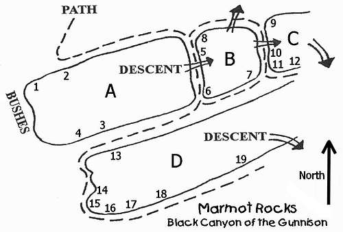
This is the diagram that the NPS provides for bouldering at Marmot Rocks, Black Canyon of the Gunnison National Park, CO.

Scenery along the South Rim
Black Canyon of the Gunnison National Park is located approximately 250 miles southwest of Denver.
South Rim: 15 miles east of Montrose, via U.S. Highway 50 and CO Highway 347, the turn off for Highway 347 and Black Canyon is well signed.
PUBLIC TRANSPORTATION - no recommended
By bus: To Montrose or Grand Junction (This option requires a lot of waiting for connecting buses at Greyhound stations. Not recommended).
By train: To Grand Junction only (There is a train between Denver and Grand Junction)
There is no public transportation within the park, or from Montrose to the park.
PLANE
Commercial airline service is available to Montrose, Gunnison and Grand Junction. You can rent a car at the airport.
Description

Corridor between Paint Bucket and Linquin Block

My son's turn

Ivory Block

Serpentine Block Splitter
The bouldering area is near the Painted Wall Overlook. There are four solid granite blocks with cracks, steep faces, and slab problems.
How to find these boulders? From the entrance station, drive west for 5.2 miles on South Rim Drive road and park at the Painted Wall Overlook. From the parking area, hike 175 yards west up the road, past a curve in the road. There is a small unmarked trail, follow it for about 150 feet to the granite blocks.
You can pick up a free description handout about Marmot Rocks bouldering at the Visitor Center.
The park handout does not describe names of the boulders, and names those A, B, C, and D. However A Falcon Gude to BOULDERING COLORADO names these boulders . I know this is confusing! I usually follow just the park's free handout. I would not have even considered comparing the route descriptions, only when writing this for SP, I noticed the difference. Anyway, park handout has slightly more routes, and the boulders are very easy to identify from both descriptions.
Ivory Block - this is the first block you will see on the left as you approach. This would be Boulder A per park handout. It is the second largest of the four, yet it is wider than the larger Serpentine Block. The Falcon Guide to Bouldering has 6 routes described ranging from V0 to V3. It is easy to scramble down from the top of this boulder. The free park handout describes 11 routes, and as the descent it recommends to jump from this boulder to Paint Bucket Block (= Boulder B) and there is a descent path on the north side of this boulder.
1. Tan Line V3 Climb up just left of the center of the north face, utilizing the white holds.
2. Ivory V3 Climb up the lengthy center of the north face, utilizing layways.
3. Neon V2 Climb up the leaning flake on the far-right side of the north face.
4 .Fluorescent Climb up the northwest arete
5. Light Crack V0 Climb up the right hand crack, on the left side of the south face.
6. Lightning V2 Climb up the face just right of the right crack on the south face.
Paint Bucket Block - this corridor-forming block is just left (east) of Ivory Block It has 4 routes ranging from V0 to V3. The park handout calls it Boulder B, and describes 7 routes.
1. Brush V0 Climb up the slab on the left side of the northwest face.
2. Easel V1 Climb up the northwest prow up and right from the horizontal break down low.
3. Oils V2Climb up the southwest arete from the south face.
4. Acrylic V3 Climb up the crack on the left side of the east arete.
Linquin Block This is the left most of three in a line, just east of Paint Bucket Block and forming another corridor between the two. It has two described routes: V1 and V2. Park handout calls it Boulder C, and describes 4 routes on it.
1. Canvas V1 Climbs up the small holds on the left side of the west face.
2. Gesso V2 Climbs up the southwestern prow moving left up top.
Serpentine Block This is the largest, elongated block with a letter V formed by two cracks on its north face. Good problems abound on this choice granite. It has 9 described routes from V0 to V3. This would be Boulder D per park's handout, and they describe 14 routes. This is my favorite boulder.
1. Left Line V0Climb up the left line forming the V on the north face.
2. Right Line V0 Climb up the lengthy right line forming the V.
3. Isadry V2 Climb up the far right side of the north face just left of the prow.
4. Splitter V0 Climb up the dihedral crack just right of the center on the west face.
5.Snakes V3 Climb up the far right slab of the west face.
6. Temptation Crack V2 Climb up the steep, southwest line.
7. Stoner V1 Climb the face left of the off-width on the south face.
8. Dragon V1Climb up the thin face right of the off-width.
9. Sea V0 Climb up the slab right of the center of the south face.
Red Tape

Mule Deer

Pets
There is an entry fee to visit The Black Canyon of the Gunnison National Park. The entrance fee is $15.00 per vehicle at the South Rim entrance station. It covers all persons in a single, private, noncommercial vehicle and is valid for seven calendar days. The entry fee for pedestrians, bicyclists, motorcycles is $7.00 per person, not to exceed $14.00 per vehicle. There is no fee charged for persons 16 years of age or younger. The national park website lists no charge visit days on their website. You can also buy Black Canyon Annual Pass for $30.00. There is no fee to enter Black Canyon National park during the winter time.
A wilderness use permit is required for all inner canyon travel, but not for bouldering or hiking along the rim.
Wood gathering is prohibited.
Wood fires are not permitted in the inner canyon.
Pets are allowed in designated areas only, and not in the inner canyon. Do not leave your pet unattended in a vehicle or campsite.
Practice Leave No Trace while in the canyon. Littering will not be tolerated.
Camping

Daisy

Deer Stampede through campground
The South Rim Campground is perched on the South Rim of the Black Canyon, and there is a nice trail Oak Flat Loop along the rim to get views of this incredible scenery.
There are evening educational programs and stargazing. Check out the schedule at the Park's Visitor Center.
Park information about camping
You can access Tomichi route from the campground if you choose to hike down to the bottom of the canyon. Don't forget to pick a free permit at the Visitor Center for inner canyon hike.
You can also stay in Montrose, there are plenty of lodging opportunities.
Relative Bouldering Scales
| Yosemite | V system | B system | Fontainebleau |
| V0 | B5.8 | ||
| V0 | B5.9 | ||
| 5.10a/b | V0 | B5.10 | |
| 5.10c/d | V1 | B5.10+ | 5c |
| 5.11a/b | V2 | B1- | 5c |
| 5.11c/d | V3 | B1 | 6a |
| 5.12a | V4 | B1 | 6b |
| 5.12b | V5 | B1+ | 6c |
| 5.12c/d | V7 | B2- | 6c |
| 5.13a | V7 | B2 | 7a |
| 5.13b | V8 | B2 | 7b |
| 5.13c/d | V9 | B2+ | 7b+ |
| 5.14a | V10 | B2+ | 7c |
| 5.14b | V11 | B2+ | 7c+ |
| 5.14c | V12 | B2+ | 8a |
| 5.14d | V13 | B3 | 8b |
| 5.15a | V14 | B3 | 8b+ |
External Links
- Marmot Rocks on Mountain Project I don't know where mountain project got the names of the boulders/route. The names are different from below mentioned Bouldering guide to Colorado, and also different from the NPS handout.
- I went by names used in A Falcon Guide to Bouldering Colorado by Bob Horan, and compared those to the NPS handout information.
- Climbing Weather for Black Canyon
- Information on Rockclimbing.com
- National Park information Wiki Page
- NPS information site