
-
 18904 Hits
-
 85.36% Score
-
 20 Votes
|
|
Route |
|---|---|
|
|
38.56693°N / 107.75145°W |
|
|
Hiking |
|
|
Spring, Summer, Fall, Winter |
|
|
Half a day |
|
|
Class 3 |
|
|
Overview
 Warner Point
Warner route has the least amount of loose rock underfoot, and is not as steep as the other two below mentioned routes. I think that camping is equal or better than on Gunnison route, and definitively much better than campsites on Tomichi route. There is a backcountry toilet at the bottom of this route.
Don't confuse the name Warner Route with Warner Point Nature Trail. The Warner Route will branch off the Warner Point Nature Trail.
Both are named after Rev. Mark Warner who was a presbyterian minister. He began his first pastorate in Montrose in 1918. Reverend Warner loved the Black Canyon of the Gunnison and was instrumental in getting the first road built there in 1930 and also very instrumental in getting the canyon designated as a National Monument in 1933. He and a local photographer, Dexter Walker, braved the depths of the Black Canyon in a boat in order to get photos for a book they co-authored. Warner's name is forever be linked to the history of the Black Canyon.
Times in the table are very generous. I did all routes in much faster times. I took 1 hr and 10 min for descent on Warner Route (snow on the trail and very slippery) and 1 hr and 40 min on the ascent.
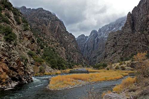 Island in the Gunnison river Island in the Gunnison river |  Gunnison River Gunnison River |
Getting There
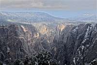
 Painted Wall
 Views along South Rim
Black Canyon os the Gunnison, South Rim is located 15 miles east of Montrose, via U.S. Highway 50 and co Highway 347.
Plane: Commerical airline service is available to Montrose, Gunnison and Grand Junction.
Route Description
 Start of the hike
 Serviceberry bush
The route starts at the Warner Point Trailhead, which is located at the west end of South Rim Drive. There is a large parking lot, restroom s, and a sign pointing the start of the hike.
First, you follow Warner Point Nature Trail. You can pick up a pamphlet at the trailhead A Walk with Mark Warner, that describes features that are indicated by numbered posts along this nature trail. The nature trail leads west along the high ridgeline. There are several benches along this trail.
You walk up the hill past post # 13. Look for a large Utah serviceberry bush on the left that is marked with a small silver sign, titled "Serviceberry Bush" (see photo on your right). This is the start of the Warner Route. The path leads to the left on a good trail.
The route skirts around the backsite of the Warner Point, passes the first drainage, and then continues west to the lowest saddle on the ridge. Turn north here, dropping through Douglas fir, and following an obvious path. Near the bottom, cairns mark the way to the river. You can hike both upriver or downriver for about 0.5 mile, with good campsites along either route. There is a backcountry toilet upriver as well.
I think that this trail is easier to follow and walk on than Gunnison and Tomichi routes to the river. The canyon opens up along the river, and there are many opportunities for camping (not just 5 as listed in National Park information booklet, but I guess they want to keep it uncrowded).
 |  |  |  |  |  |
Essential Gear
 Yellow copy
Good boots - I used lightweight alpine La Sportivas since the trail was covered with snow. I also carried crampons, but did not use those.
A lot of energy!
Trekking poles may be helpful, but you will encounter sections when hands will be needed.
A lot of water in the summer (it does get very hot down there).
Backcountry permit is required for all inner canyon hikes. You can obtain the permit in the visitor center if they are open, and if they are closed there is a box with permits just outside the visitor center. Park rangers remove the permits during their operating times.
Park rangers keep the original, white copy, and you are required to hike with the yellow copy. You have to return the yellow copy on your way back either to the visitor center, or to the box outside the visitor center. I you forget they may start search and rescue!
 |  |
 |  |
Mule deer
The mule deer (Odocoileus hemionus) - I kept running into those guys during my hike. I took more than 30 photos, and had a hard time choosing which ones to post.The mule deer is the largest of the Odocoileus genus, standing the average, 40-42 inches (100-110 cm) at the shoulders and stretching 80 inches (200 cm) or so nose to tail. An adult buck will weigh from 150 to 300 pounds (68-140 kg). The occasional trophy-sized mule deer buck may weigh up to 500 pounds (230 kg).
The mating season usually begins in the fall. Does may mate with more than one buck (wow). The gestation period is about 190-200 days, with fawns born in the spring, staying with their mothers during the summer and being weaned in the fall after about 60-75 days. A buck's antlers fall off during the winter, to grow again in preparation for the next season's mating.
There are several predators of mule deer. Gray Wolves and cougars are the main ones, and of course humans. Bobcats, Coyotes, and bears less commonly prey on adult deer, though commonly attack fawns.
 |  |
External Links
National park info about inner canyon hikes