
-
 3723 Hits
-
 80.49% Score
-
 12 Votes
|
|
Mountain/Rock |
|---|---|
|
|
46.44643°N / 14.42751°E |
|
|
Hiking, Trad Climbing, Scrambling, Skiing |
|
|
Spring, Summer, Fall, Winter |
|
|
6755 ft / 2059 m |
|
|
Overview
Name
The Slovenian Tolsta Košuta means a Fat Hind and refers to the mountain look from the southern side. The German name Dicke Koschuta is a direct translation, meaning the same, even if from the Austrian side the mountain looks like a sharp peak.
Character
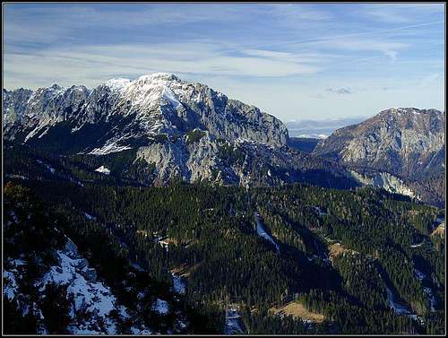
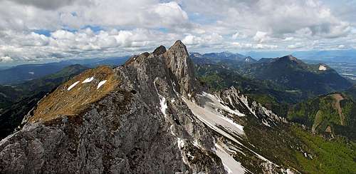
Tolsta Košuta is the last, easternmost high summit of the long Košuta range. Its characteristics are very similar to characteristics of the other summits, but it also has a few specifics. Actually, the mountain has two summits, some good 10 minutes apart. The eastern summit's altitude is 2057 m, the western's 2026 m.
Some 30 years ago Tolsta Košuta was an abandoned mountain, very rarely visited. The path from the Austrian side was not maintained, the easy route from the Slovenian side was prohibited due to border. Today everything is changed. From the Slovenian side the mountain is often visited, even in the times of tour skiing. On the Austrian side, the geologic site called Meli is often visited and the marked trail can bring you also on the summit. And the additional reward on the summit is a wonderful view on the sharp Košutnikov Turn and in all other directions.
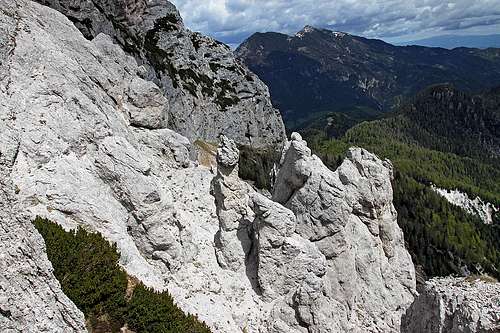
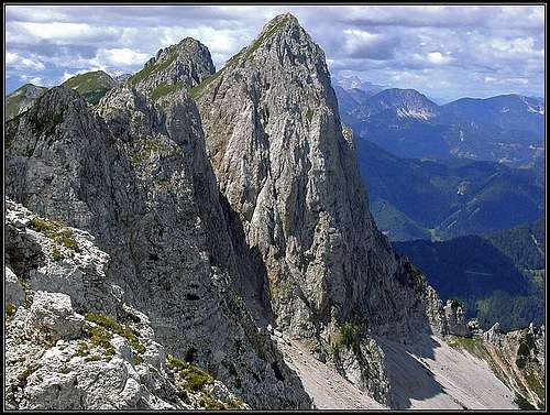
So, from Košutnikov Turn to Tolsta Košuta the main ridge stretches. In this section it is quite sharp and not so easily passable. The first 4 ridge towers are called Gamsovke / Freibachwand, 2065 m. East of them 3 ridge bumps are called Obliči / Doborwaspitzen, 2026 m, then the 2 summits of Tolsta Košuta come. From the main ridge towards the north a steep rocky wall is falling, towards the south there are a bit less steep grassy slopes, partially intermitted with rocks. On the eastern summit of Tolsta Košuta the main ridge turns towards the SE, on Orlovo sedlo / Adlersattel, 1672 m. There's a small elevation, called Mala (=Small) Košuta, 1739 m. The continuation of Košuta ridge however goes in the E-NE direction. First it drops almost vertically, then the ridge levels to Potok saddle, 1411 m, from which a streak of lower, mostly forested summits continue till the Šajda road pass, where Košuta massif really ends.
The eastern face of Košuta is a special one. While around the summit it is made of more compact Dachstein limestone, and below it a layer of bedded limestone, from the altitude of some good 1800 m down the brittle Schlern Dolomite prevails. This results in a chaos of towers, sands and ravines, finally settling much below in the valley of Košutni potok / Potokbach. The whole area is of great geological importance.
Getting There
Trailheads for Tolsta Košuta are much the same as for Košutnikov turn:
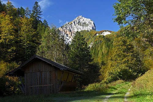
- Dolga Njiva alpine meadow is on the southern side. Just below it from Tržič town a mountain road reaches. The parking place is on some 1255 m (46.430429, 14.411720).
- The upper valley of Freibach / Borovnica. This is the northern trailhead. From Zell-Schaida, near the Terkl Hotel, we turn southwards and drive by a good asphalted road past a sports centre and Olip farm till the last parking place on 980 m (46.460360, 14.425207).
- Trögern / Korte valley can be a trailhead, but the safe route is long and follows many forest roads till below Mala Košuta. The ascent route through Potokgraben / Košutni potok starts on the main road (46.452930, 14.489138).
The map above is quite precise and can be used for hiking. It clearly shows the SW route start (on the road), Dolga Njiva hut, the upper meadow, the ascent on Orlovo sedlo / Adlersattel and then northwards to the top. The northern route starts in Freibach / Borovnica valley, goes southwards on Potoksattel, then across Meli further to Orlovo sedlo / Adlersattel and right on the top. Forest roads from Troegern / Korte are long and less useful, the same holds true for the trailhead in Potokgraben.
Summit Ascents
1. From Dolga Njiva meadow
From the parking place we follow the mountain road a few minutes, then soon we deter left, following the red marks till the shepherds hut on Planina Dolga Njiva. From there, we continue along the dry creek bed (Košutnik) in the E-NE direction. In some 20 minutes we reach the nice upper part of the pasture. There, the eastern trail on Košutnikov Turn deters left, but we continue in the same direction and then a bit left on the main ridge. We reach it on the notch where also the Austrian marked trail comes up from the other side (Orlovo sedlo / Adlersattel, 1672 m). To the right is the bump of Mala Košuta. But Tolsta Košuta we see all the time on the left. So, from the notch we walk up by a weak trail in the NW direction. The slope gets steeper and steeper, just below the summit the trail requires some sure-footedness. On the Swiss Hiking Scale the difficulty would be T3, some 2 h 15 min from the parking place.
This is also the route of a ski tour, only that when skinning up, we are trying to stay in open terrain. The slopes just below the summit are very steep, so a lot of care and good conditions are needed. SAC Scale grade: AD-. As these are the southern slopes, snow usualy gets softened soon in the morning. From the summit we can also ski down directly on the upper meadow, staying close to a steep, below a bit overgrown ravine.

|

|

|
2. Over Meli
It's an old passage across the picturesque eastern face of Tolsta Košuta. Due to brittle rocks, the cables for securing the trail are often damaged, so the trail can be quite demanding. The first place to reach is Potok saddle, 1411 m. In 1 hour it can be reached by a marked trail from the parking place in the upper Freibach / Borovnica valley. From the saddle the trail enters into the geologically interesting eastern face of Tolsta Košuta. It crosses the slope, ascending into the chaos and then winding through ravines and around towers. After 1 hour 30 minutes we exit on the notch in the main ridge, just below Mala Košuta (Orlovo sedlo / Adlersattel, 1672 m). Then towards the right on the summit, as described under #1. Altogether some 3 h, T4.
3. From Košutnikov Turn
The connecting main ridge from Košutnikov Turn to Tolsta Košuta is a climb of nice variety and of UIAA II+ difficulty. In the opposite direction it is described on the page of Košutnikov Turn. In combination with the above described route #1 we can make a nice round tour.
Košutni potok / Potokbach
On Google Map this valley is named also Koschutabach. So, I'm shortly describing here a nice valley which is only of a limited importance for the ascent on Tolsta Košuta, lying NE of it. The brook flows into Trögernbach just south of the well known Trögernklamm / Korške peči (canyon). There's also a parking place (and restaurant) where we must leave our car.
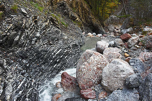
The forest road into the valley is closed for public traffic, because since 1977 the valley is proclaimed a forest natural reserve. After some 30 minutes the nice road ends (2019), crossing the creek bed. There we simply continue straight along the creek in the W-SW direction. The creek ravine is easily passable, but terrain is completely pathless. Only a few cairns can help us choosing the best passages. The scramble gets more and more interesting. The most picturesque are colorful boulders of Tarvisio Breccia. This mostly red paleozoic rock has nice grains of white limestone, quartz, and other rocks. All those boulders came down to the creek from landslides higher up on the eastern face of Tolsta Košuta. Then by the creek there are nicely folded layers of Triassic limestones and marls, then black plates of slate and many other types of rocks. All these are surrounded by light grey towers and crags of brittle Middle Triassic Schlern Dolomite.
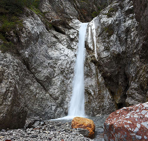
So, we scramble up the creek, many times crossing its stream. The first cascade (only some 5 m) we detur by the left side (looking up), then we continue some good 20 more minutes. The route ends below a beautiful, some 15 m tall waterfall. Very nice corner!
|
|
Supposedly above the waterfall a hunters' path crosses the steep, brittle rock terrain towards the right. Higher on, there's a hunters hut and the trail ascends some 200 more meters of altitude on Potok saddle. But the beginning of the trail is unclear. It must be much below the waterfall, leaving the creek bed towards the left (southwards).
When to Climb
Tolsta Košuta can be ascended almost in any season, only perhaps hard winter time with a lot of snow is too dangerous due to very steep slopes. Dry season is from June till end of October, ski touring season is from end of January till May. Ascents in winter conditions require proper equipment (at least ice pick, in hard snow also crampons).
Mountain Huts
Suitable is only the shepherds hut on Dolga Njiva meadow. I guess they can offer you also some drink and food, perhaps no hiker sleeps there.