
|
|
Mountain/Rock |
|---|---|
|
|
36.05310°N / 51.46730°E |
|
|
Hiking, Mountaineering, Sport Climbing, Bouldering, Scrambling, Skiing |
|
|
Spring, Summer, Fall, Winter |
|
|
13635 ft / 4156 m |
|
|
Overview
Koloon Bastak is also known as Khortoo-akClick for Introduction to the Central Alborz Mountains.
Click for a Map of the Koloon Bastak Area Mountains.
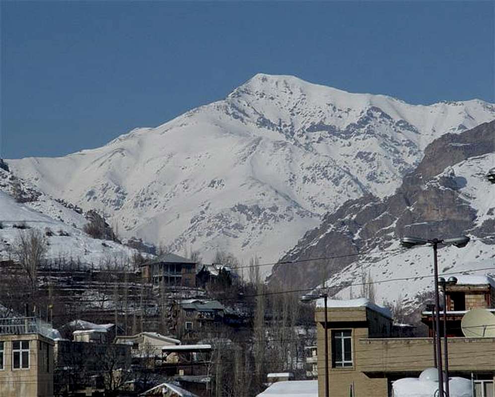
South face seen from meygoon village.
Kooloon Bastak is one of the 4000m peaks that sits on one of the the east-west ridgelines in the middle part of centeral alborz mountains.
The first east-west ridge of this part is the Tochal massif(3965m) that sits north to Tehran, and roughly the second ridgeline north to Tochal is the Sarakchal-Koloon bastak. there are some hills and lower mountains between this ridgelines.
The 7Km ridge starts with Koloon Bastak at west drops to 3850m and continues to Sarakcha peaks at east.
See Sarakchal peaks:
Sarakchal (4210 m)
Despite being close to Tehran, the weather conditions are not the same for Tochal and Koloon bastak. While the temp is -7C at 1700m on Tehran, on the other side at 1400m it can be -12C.
Koloon Bastak can be the easiest peak of the alborz, thanks to the Shemshak-Dizin road that goes up to 3250m on the south face of the peak. So climbing up to the peak will only take 4 to 7 hours (in good conditions).
The purpose of this Shemshak-Dizin road (about 12Km) located on the steep Srakchal-Koloon bastak slopes passing through the harsh conditions, remaining under heavy snows, tolerating dozens of avalanches that are meters high, rock falls, ground slides sweeping the road... is to reach the upper parking and middle station of the Dizin ski resort. Shemshak and Dizin are the most famous resorts near Tehran, I read on some ski web sites that Dizin resort is said to be one of the best and cheapest ski resorts around the world (claimed by people from Iran, Europe, Usa and Emirates that have skied on it). the resort top is at about 3700m, on the north slope of mount Seechal see :
Mount Seechal
The Theran-Shemshak-Dizin road about 60Km is the nearest road, so many skiers use ths road despite to the danger. Ans beside the ski this road gives the opportunity for the climbers to start higher.
Anyway the west less climbed face starts from the bottom of the valley and is a harder challange, having walls of rock and ice at colder seasons for technical climbers.
The top gives a good view of the Alborz, Tochal and Seechal at south, Damavand, Kholeno area, Sarakchal, Abak... at east, Naz, Kahar, Takht-e-Soleiman massif at west and the middle part of centeral alborz ridgelines with the impressive tip of the Azadkooh outstanding at north.
-------------------------------------------
This part is originally written by Nader :
If you ever go to the ski resorts of Shemshak or Dizin in the Alborz Mountains north of Tehran, you are likely to be impressed by the imposing summit of Koloon Bastak rising above the slopes. Although the most dramatic scene from the top of Dizin is probably that of the giant cone of Mt. Damavand soaring to 5671 m in the eastern horizon, Koloon Bastak is much closer and in my opinion appears equally as impressive.
Koloon Bastak is one of the 4000 m plus peaks of the Middle Wall of Central Alborz (see link above). Its proximity to Tehran and the fact that a road climbs its slopes up to 3250 m makes it the most readily accessible 4000 m peak of the Central Alborz Range.
To the east, a 7 Km long ridgeline that drops to a minimum of 3830 m connects Koloon Bastak to a series of peaks known as Sarakchal (4210 m). The southern slopes of Koloon Bastak, Sarakchal and the connecting ridgeline drop steeply to the villages of Shemshak & Darband Sar (2600 m) near the bottom of the valley where the Jajrood River originates. These slopes create a very impressive wall that is well visible from Shemshak and the Dizin Ski Area.
To the southwest, a 3250 m saddle known as Dizin Pass separates Koloon Bastsk from the 3719 m Mt. Seechal (Dizin Ski Area). To the west and north, the slopes of Koloon Bastak drop to the bottom of the Velayat Rood River Valley.
From the village of Shemshak, a road climbs the southern slopes of Koloon Bastak to reach Dizin Pass (3250 m) at the top of one of the ski lifts (on the north slopes). The southwestern ridgeline can be followed from the pass to reach the summit (see South Route by Nomad).
Getting There
Reach south face :Option 1) Call 131 and ask if the road is usable. From northeast Tehran drive 50 Km (use Sadr and Babaei highways toward east run off at Fasham sign) to the village and ski resort of Shemshak (2600 m). Follow the road another 12 Km up the southern slopes of Koloon Bastak till you reach a parking lot above the "Darreh" Gondola Line in Dizin. This is your trailhead. The route to the summit is obvious.
Move up towart the telecom antennas.
Reach west, north or south faces :
Option 2) From downtown Tehran drive 40 Km west to the town of Karaj, then follow the Karaj-Chalus Road 70 Km north till you reach a 12 Km long side road that will take you to the bottom of Dizin Ski Resort (2700 m). Take the "Darreh" Gondola Line to the trailhead (see map).
The west face is in front rising up from the river.
The north face requires to pass the river and go toward north and east along with the river.
To reach the south face you have to use the lifts to go to the 3300m and walk few meters to 3250m (winter)
or drive up the very steep soil road up to the 3250m point, this road is no usable in other seasons as its fully filled with avalanche and snow. (summer)
When To Climb
The easiest season is in summer, early summer is perfect there is snow and a lot of colourfull plants on the slope. Other seasons needs tracing weather forecast to find a clear weather, as the heavy snow, lighning and violent avalanches and snow storms exist.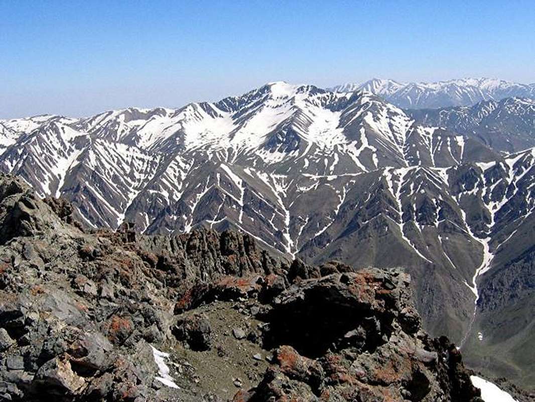
Naders shot of the much more rarely seen north face of Koloon Bastak as seen from the summit of Kaman Kooh
nader - Oct 31, 2002 10:27 am - Voted 10/10
Untitled CommentThank you for the coordinates and thank you for Sarak Chal.
Nader
shaghayegh group - Oct 31, 2002 7:36 am - Hasn't voted
Untitled CommentThe Geographical coordinations are:
longitude =51:20 E
Latitude= 36:04 N
nader - Oct 31, 2002 10:27 am - Voted 10/10
Untitled CommentThank you for the coordinates and thank you for Sarak Chal.
Nader