
-
 12898 Hits
-
 86.85% Score
-
 23 Votes
|
|
Mountain/Rock |
|---|---|
|
|
46.43460°N / 13.68386°E |
|
|
Mountaineering, Trad Climbing, Scrambling |
|
|
Summer, Fall |
|
|
7795 ft / 2376 m |
|
|
Overview
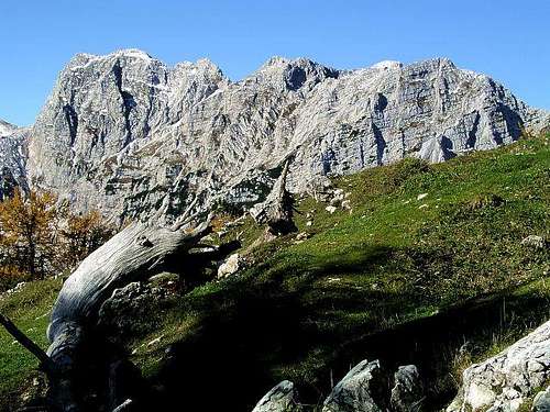
Kotova špica (far on the left) from the east
What's New Here?
> Aug 13th, 2022: Interactive map-guidebook embedded
> Feb 12th, 2020: Map embedded, descriptions corrected.
> Jan 17th, 2019: Design corrections.
> Feb 22, 2015: SP V3 design applied.
> Dec 28, 2004: Initial setup of the page.
Kotova Spica Gets Presented
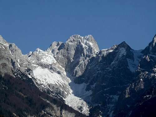
Kotova špica is a sharp southernmost double peak of the long side crest which comes from the north from Visoka Rateška Ponca and over Vevnica. The main crest of Julian Alps, coming from Mangart on the west, turns southwards on the summit, called V Koncu špica, 2350 m. From it, towards the north branches the Vevnica and Ponce crest, while towards the south the sharp Kotova špica stands. Further towards the south the crest drops down on the broad Kotovo sedlo (saddle), 2134 m and beyond it continues towards Jalovec.
Most nicely the mountain is presented from Kotovo sedlo - as a sharp, hardly reachable cone peak. But great is also its W face - there the walls are falling steeply into the valley-end of Koritnica. Only a bit less steep and impressive is the E face, looking towards Tamar and Planica valley.
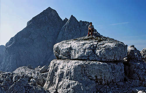
Although being so nice, often admired by tour skiers from Kotovo edlo, Kotova špica is seldomly ascended. The reason is a hard and complicated normal route from the less populated western side. The once secured route is now destroyed by avalanches and is for non-climbers quite hard to do. But reaching the big summit mushroom is a rewarding experience and also the panorama on all sides is great. Especially nice is the sharp-edged Jalovec and its north face. The nearby V Koncu špica, 2350 m is less important as a mountaineering goal. It can be reached by easy climbing from the saddle between it and Vevnica (UIAA II) or from the notch between it and Kotova špica (UIAA II).
Summit Views
 Jalovec from the summit of Kotova špica
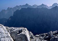 From Kotova špica towards the east
Due to its height and central position the views from Kotova špica are very nice and various. The most attractive is the view on the mighty Jalovec, which sharp edges and northern wall are rising just on the other side of Kotovo sedlo. Across Planica valley we can admire the long, monolythic wall of summits from Mojstrovke over Travnik to Šite. More in the distance, above that wall, all other principal summits of Julian Alps can be seen - from Martuljek group, over Škrlatica, Prisojnik, Razor to Triglav and its neighbours. Towards the west, we can see the strong ridge, rising on the summit of Mangart and towards the north there is the ridge on Ponce.
Getting There
For the general orientation see the Julian Alps group page and the Mangart & Jalovec subgroup page!
1. One long ascent goes from Planica valley. In this case you must reach Rateče village in the upper Sava valley and drive in Planica side valley to Tamar alpine meadow, where the trailhead starts. The upper Sava valley can be reached from the Central Slovenia (via Jesenice), from Italy (via Tarvisio) or from Austria (via Karavanke tunnel or one of passes over Karavanke ridge).
2. The second ascent on top goes from Koritnica valley. In this case you must reach Log pod Mangartom (on the road Bovec - Passo Predel) and continue by a cart-road into the end of Koritnica valley.
3. The third option is very rarely done. You could start at Laghi di Fusine (lakes, reachable from the road Tarvisio - Kranjska Gora), ascend by Via della Vita (hard ferrata) the Bivouac Tarvisio, 2160 m and do the crossing of V Koncu špica, 2350 m and the ridge to Kotova špica.
Maps:
- The below interactive map-guidebook is the most accurate.
- Julijske Alpe - Zahodni del. Planinska zveza Slovenije. 1:50.000
- Tabacco: Alpi Giulie Occidentali Tarvisiano. No: 019. 1:25.000 (very good!)
- Mangart - Jalovec. Planinska zveza Slovenije. 1:25.000.
Routes Overview
| See full screen |
1. The normal ascent from the end of Koritnica valley (called V Koncu = At the End). You can reach this point either from Planica valley over Kotovo sedlo, or through Koritnica valley. The joint point of both approaches is on the altitude of some 1680 m. From there you proceed by the marked path towards Žagerica (notch), but only to the branching on some 1900 m. You have already passed the W walls of Kotova špica. There a weak trail branches right (the trail was built after the World War I). By it you cross by an exposed ledge, then ascend up, cross a ravine and on the other side climb up on the notch between V Koncu špica and Kotova špica. Then southwards to the highest point. UIAA I-II, from Tamar cca 6 h, from Log cca 5 h. 2. From Laghi di Fusine towards the south and by Via della Vita (difficult ferrata) to the saddle between Vevnica and V Koncu špica. Then crossing the summit of V Koncu špica to the notch between V Koncu špica and Kotova špica (UIAA II) and to the highest point. Cca 5 h. 3. As Bor describes, the saddle between Vevnica and V Koncu spica can be also reached over the southern slopes of Vevnica. That would be the fastest approach from Planica valley. UIAA II. Cca 5 h. 4. The most natural route on Kotova špica is to climb the 200 m high walls above Kotovo sedlo (saddle), 2134 m. That route was used by local hunters even before the first climbers came. So, the easiest ascent from the south starts on Kotovo sedlo, detours the nerby Špice v Planji, 2198 m (see the map on the left), and goes then by a ledge on the main ridge. Then the route follows the main ridge, partly over distinct slabs, until it reaches the steep walls. So, from above the slabs you cross left into the W wall and then right up on the S fore-summit of Kotova špica (that's the most difficult part). Then northwards on the main summit. UIAA II+, Good 1 h from Kotovo sedlo. The route is not drawn on the map on the left. |
Red Tape
The mountain is in the Triglav National Park, otherwise no limitations.
When To Climb
In summer and autumn - the best months are July to October.
For weather see here. Even better site is wunderground - here's the direct link to Kredarica station, 2515 m (below Triglav summit).
Camping
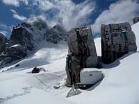 filova - Bivouac below Kotovo sedlo
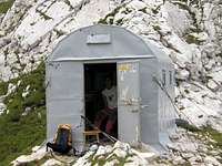 Bor - Bivouac Tarvisio
The two useful huts and two bivouacs are:
- Dom v Tamarju, 1108 m, (04) 5876055,
- Rif. Luigi Zacchi, 1380 m, 0428.61195.
- Bivouac below Kotovo sedlo, 1985 m.
- Bivacco Alberto Busettini (e-mail: caitarvisio@inwind.it, address: Municipio di Tarvisio, via Roma 3, 33018 Tarvisio (UD), tel. 042-82037), 2149 m, always open, 9 beds, on Žagerica notch. By Via della Vita 3 h from Rif. Zacchi, through Koritnica valley over Žagerica notch 4 h 30 min.