|
|
Mountain/Rock |
|---|---|
|
|
46.38648°N / 13.61423°E |
|
|
Hiking, Mountaineering, Trad Climbing, Scrambling |
|
|
Spring, Summer, Fall |
|
|
7329 ft / 2234 m |
|
|
Overview
The most common view of Vrh Krnice is probably the one you get while leaving the town of Bovec upstream, towards Italy or Kranjska Gora. At first, one views Svinjak, "the Bovec Matterhorn", and then Vrh Krnice to the left.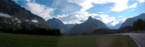 visentin - Vrh Krnice (left) and Svinjak
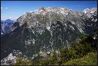
Being the south end of the array (downstream), Vrh Krnice spreads out immensely into fore hills, some named, and all overgrown with forests. The majestic appearance of the southern view is also due to both shoulders/arms in the summit part, with V Gradu, the major outcrop to the left, and Kobila, the double summit on the ridge to the right.
The northwest face of Vrh Krnice is the wall climbers are interested in. Note though that in this case, it certainly is a good idea to know how to descend (along the standard ascent). The NW wall was first climbed in the 1980s and according to primorskestene.com, it accepted four routes until now, all in the UIAA VI- to VI+ range (450 to 550 m tall). Check the external links below for beta. No winter ascents on Vrh Krnice, but therefore on the neighbouring "V Gradu" (also WI).
Vrh means summit, and a "krnica" is a high perched terrace or ground (read shepherding).
![Mangart and Jalovec Group]() Vrh Krnice is outer right. Please enlarge to original size and see the "krnica", to the right of the summit. Pano by :Vid Pogachnik
Vrh Krnice is outer right. Please enlarge to original size and see the "krnica", to the right of the summit. Pano by :Vid Pogachnik
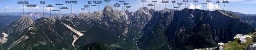 Vrh Krnice is outer right. Please enlarge to original size and see the "krnica", to the right of the summit. Pano by :Vid Pogachnik
Getting There
Standard ascent : Kluže Trailhead (532 m).Route
Vrh Krnice standard ascent: unmarked hunter's path until cca. 1700m alt. Further: no path or cairns. 5 to 6 hour ascent. The line appears on the Tabacco map (see External Links below). Some authors recommend a piolet and crampons if the grass slope between the cables is wet. This route is only recommended for experienced scramblers with a very good sense of terrain orientation. Consider appointing a mountain guide. Vrh Krnice standard ascent (line)
Start to the left of a small parking niche, 50 m along the road signposted Bavšica at the Kluže fortress (alt. 532 m). The path twists and turns up a steep forest and reaches a hunter's lodge at 1032 m. Continue to the right of the lodge. As the path forks, choose the right hand branch. Another small hunter's lodge appears at 1300 m. Continue until forest line, the path then following a ridge covered with low vegetation. The ridge becomes rockier and as difficulties appear, cables circle the problem to the right, below the ridge. At the end of the cables, a few cairns help one cross a very steep (and exposed) grass flank before reaching more cables. At the end of these cables, we are again on the thin ridge. The faint path now avoids the ridge on its left side through high grass and below the last larches, until reaching a grassy saddle (cca 1700 m). The pyramidal summit seen above is Vrh Male Krnice and it blocks the view of our goal.
From here on, no more path and no cairns. Cross the large basin/slopes horizontally towards the ridge on the opposite side, but below the lowest rock band. Aim for the scree drip and then follow it up to what seems to be a dead end. A narrow gully (till then hidden) opens a way up. UIAA I. Exit to the left and reach the final grass slopes along which we stick to the right. After reaching the summit ridge, follow the ridge to the right for a few minutes till the summit cairn.
 Approximate line. Enlarge.
 |  Konrad Sus - Kluže
 | 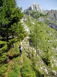 Lower part of the path
 |
|---|