
|
|
Mountain/Rock |
|---|---|
|
|
46.42339°N / 13.69210°E |
|
|
7562 ft / 2305 m |
|
|
Overview
Geographical structure: Eastern Alps > Julian Alps > Mangart and Jalovec group.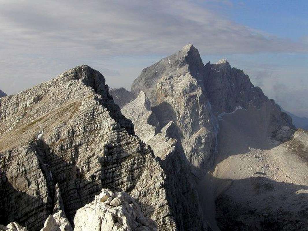
On the left is Travnik and on the right is Jalovec. Below Jalovec is an airy ridge of Site.
Site are the last mountain in the famous face above Planica and Tamar valley. If you look Site you hardly recognize the main summit because Site have many summits. But in truth there are many summits, which are located between Jalovska skrbina (notch) and Jalovec on the west and Travnik and Mojstrovke ridge on the east side. Site are hard approachable mountains and on theirs summits no marked route lead. You can find only some hunting or animal routes.
On the south side Site fall down over nice rocky and grassy slopes to the Trenta valley (Zadnja Trenta valley). On this slopes is marked route from Vrsic pass, 1611m to the Zavetisce pod Spickom, 2064m (hut). To the west side Site fall very steep on Jalovska skrbina, 2117m (notch). The last summit, which falls down on Jalovska skrbina is the highest summit of Site and the main summit. To the east side goes from Site the ridge to the Kol, 2350m and Travnik, 2379m. Before the ridge comes to these two mountains there is very nice and steep ridge where are many peaks of Site.
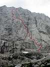
But the most powerful side Site show on north side to the Tamar and Planica valley. Here is one of the wildest faces in Julian Alps over 700m high. The face is completely vertical. From climbing side are Site very well climbed. The first climbing route was the route from the famous Slovenian alpinist Pavla Jesih (woman). This route is the easiest in Site’s north face and it is located in its “gentle” part. The hardest climbing routes are in central part of face where is face completely vertical. These climbing routes are only for very good climbers. The difficulties of the routes are arranged in all face from the foothills to the top. When you climb on the top of face you must think on long descend from the top of Site. Many climbers descend back over the north face over the route of Pavla Jesih that is the easiest.
For mountaineers are Site approachable from Vrsic pass over the ridge of Mojstrovke and over Travnik. The second possibility is over SE slopes of Site. If you decide for second possibility you can start from Tamar valley or from Trenta valley.
 |  |  |  |  |
Getting There

Mangart & Jalovec subgroup with the main summits and huts. For the interactive map check the site of Mangart and Jalovec group.
The heart of the region is Kranjska Gora resort town, 84 kilometers from the Slovenian capital Ljubljana. Starting point for Site is either Vrsic pass (12 kilometers south of Kranjska Gora), Tamar valley or Trenta valley.
By Plane:
If you want to reach Ljubljana by plane check a timetable on the site of Adria Airways, a national airline.
By Bus:
From Ljubljana buses depart towards Kranjska Gora every 60 minutes.
By Train:
From Ljubljana trains depart in Kranjska Gora direction quite often but only up to Jesenice town. There you have to change to bus, which come from Ljubljana anyway.
By Car:
From Ljubljana 84km.
From central Europe via Villach, Austria: Via Karavanke tunnel (around 40km) or Korensko Sedlo pass (around 30km).
From western Europe via Udine, Italy: exit Udine – Villach highway in Tarvisio. Tarvisio – Kranjska Gora 20km.
Maps:
 |
Routes Overview
You can reach Site from many sides. Here are three main approaches.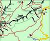
1. From Vrsic pass. From Vrsic pass you reach Velika Mojstrovka and cross the whole ridge of Mojstrovke. When you come on the last Mojstrovka you descend around 100 metres and then you ascend on Travnik. From Travnik you still reach Kol and then you come on start of the Site ridge. You cross the whole ridge to the last peak which is the highest. UIAA II/I, scramble.
2. From Trenta valley over SE slopes. You park your car in Zadnja Trenta valley (the second valley of Trenta valley) and you follow the signposts for Jalovska skrbina, 2117m (notch) and Jalovec. On the altitude around 1700m where is the crossing with marked route from Vrsic pass you go in NE direction over the SE slopes of Site and you come below the upper part of Site. You reach it by the steep grassy and rocky slopes over the easiest passages. UIAA I, scramble.
3. From Tamar valley. You park your car by Dom v Tamarju (hut) and then follow the signposts for Jalovska skrbina, 2117m (notch) and Jalovec. When you reach Jalovska skrbina you descend by marked route to the Trenta valley as long as you can cross to the left and come on SE slopes of Site. From here you reach the main summit of Site over steep rocky and grassy slopes. UIAA I, scramble and some secured climbing on Jalovska skrbina (notch).
Site are the most famous by the hard climbing routes in north face. Here are some of them.
North face
 |
Red Tape
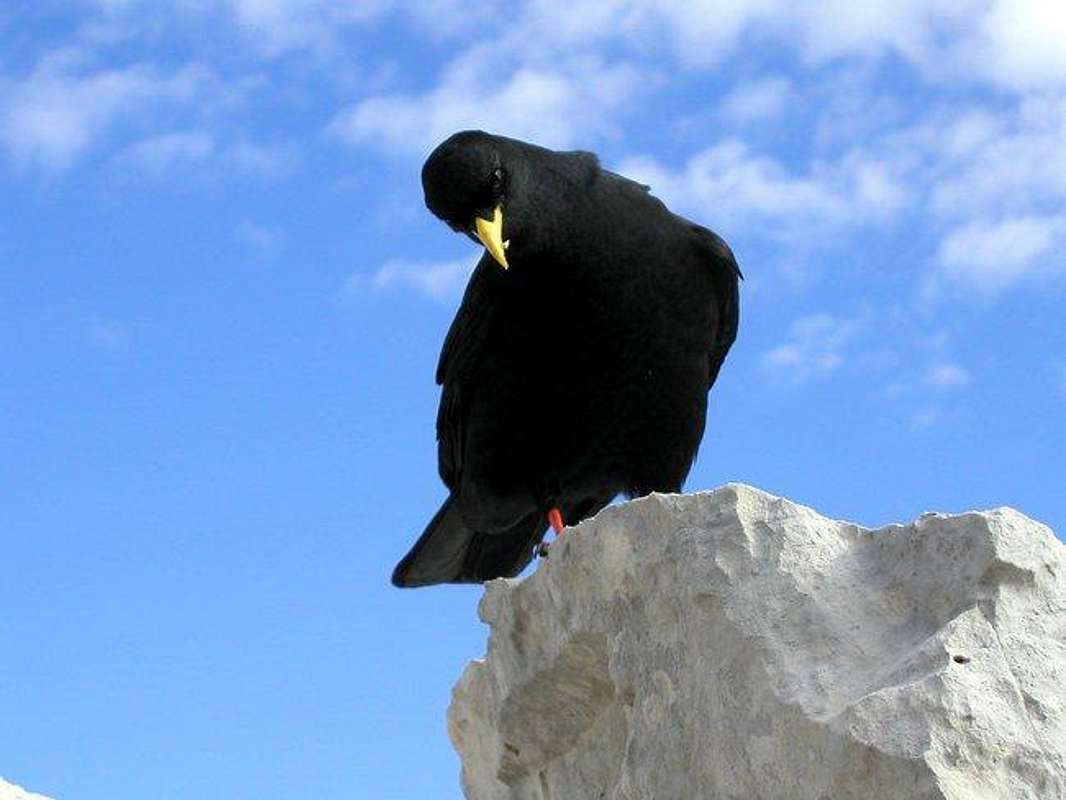
The Alpine jackdaw is very often in this area.
No limitations but Site are located in the Triglavski Narodni park so you must be kind to the nature and other beauties.
When To Climb
The best time for climbing on Site from Vrsic pass, Trenta valley or Tamar valley is Spring or Autumn. In Summer could be very hot on south slopes.The best time for climbing in Site`s north face is Summer specially July, August and September when is in north face not very cold.
 |
Mountain Huts
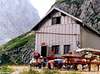
There are many huts in nearness of Site and on starting points for ascend.Dom v Tamarju (1108m) hut stands on the edge of picturesque meadow, in Tamar, which is upper part of Planica valley. Hut was built in 1899 and since than numerous times rebuilt and renewed, last time in 1984. From here is beautiful view on the towering peaks around, north wall of Mojstrovka and especially Jalovec. This is one of the most romantic spots in Julian Alps. It has 128 beds, hot water, electricity, phone etc. and its open ALL YEAR. Tamar hut is accessible by car from Ratece (6km).
Zavetisce pod Spicko (2064m) refuge stands on the scree slopes just bellow Spicek, isolated needle and high above Trenta valley. First refuge was placed here in 1935. Today it has 30 sleeping places and it is supplied in summer. In winter there is winter room available. From the hut is amazing view towards east and peaks on the other side of Trenta valley: Prisojnik, Razor, Triglav and Kanjavec.
Koca pri izviru Soce (866m) hut stands in Zadnja Trenta (upper trenta) valley, two kilometers from the junction on the Vrsic pass road. 10 minutes above the hut is source of Soca river. Since this is not very popular Jalovec trailhead it is more a restaurant than hut. It has 44 beds, electricity and is open from April to October.
Erjavceva Koca na Vrsicu (1525m) hut is standing on top of small head, surrounded by larch trees, just by the road, some hundred vertical meters or 1 kilometer in distance bellow the Vrsic pass on the north side. From the hut is beautiful view on the towering Prisojnik (2547m). First hut was built here in 1901. In 1987 it has been decided that old hut is in bad condition and no longer usable, has to be demolished and new one build, at the same spot. New hut was opened in 1991. It has 94 beds, hot water, electricity, phone etc. It is open ALL YEAR.
Ticarjev Dom na Vrsicu (1620m) hut is standing on the southern side of Vrsic pass, just by the road. First hut here was opened in 1912 and was named Slovenska Koca (Slovenian Hut). Between 1964 and 1966 a new hut has been built, just by the old one, which was demolished upon finishing the new one. In April of 1975 huge avalanche from Mojstrovka destroyed part of the hut. It has 91 beds, hot water and electricity, phone etc. and is open from May 1st till the end of October.
Postarski Dom na Vrsicu (1688m) hut is highest standing of 3 Vrsic pass huts and has most beautiful view. Since it is not accessible by car it remained truly mountaineering hut. It has been built in 1952 on a small terrace bellow the Vrsic peak (1737m), after which pass was named. It has 65 beds, electricity, phone, hot water and its open from June 1st to September 30th. 15 minutes on foot from Vrsic pass.
Camping
Camping inside the Triglav National Park is forbidden. Beside the mountain huts there are plenty of hotels and private apartments in the towns and villages, which surround the area. Here are few links where you can find info on accommodations closer and further away:Kranjska Gora
Bovec
Mojstrana
Bled
Mountain Conditions
Mountain conditions in Julian Alps are well known, thanks to Kredarica (2515m) hut and meteo station, which is below the Triglav.You can observe current conditions and forecast for Kredarica on the Wunderground meteo site. Here is direct link to Wunderground - Kredarica page.
Some weather informatin can also be found here.