
|
|
Mountain/Rock |
|---|---|
|
|
46.78260°N / 8.57060°E |
|
|
Mountaineering, Skiing |
|
|
10196 ft / 3108 m |
|
|
Overview
The Krönten crowns the head of the Leutschach valley and is very near to Spannort. It is composed of a base of gneiss overlain by a thick cap of sedimentary rock. The rock is generally decent. The approaches are over glacier/permanent snowfields. To the east of it lie 2 lesser peaks, Chli Krönten (2910 m, unnamed on the topo) and Sunnig (2839 m). Since these peaks can be combined into one long traverse of the Krönten or climbed separately, they are included in this page.Map
The Krönten was first climbed by the Reverend John Sowerby and his guides Josef Maria Tresch and Ambros Zgraggen on 3. Aug. 1868
 |  |  |
Getting There
One can get to Erstfeld via Luzern and Altdorf from the north or from the Gotthardpass from the south by train. From there, transfer to a bus for either Amsteg or Intschi. A cable car from either place takes you one step higher from whence the trail takes you in 2.5 hours to the Leutschach hut.If going to the Krönten hut, a taxi in Erstfeld will take you to Bodenberg from where it is 2.5 hours to the hut. To hike from Erstfeld over Bodenberg adds another 1.5 hours to the approach. For the taxi, reservations are needed: Alpen Taxi, Anna Arnold / Ignaz Walker, Gotthardstrasse 62, 6472 Erstfeld Tel 041 880 05 23 Fax 041 880 05 02 Natel 079 413 91 15. See a more detailed description of the route to the hut under the Routes section of this page.
If driving, Erstfeld, Amsteg and Intschi lie along highway A2. Parking is available at the cable cars and in Erstfeld.

 |  |
Routes Overview
For more detailed route description, see the SAC climbing guide, Urner Alpen, Volume 2.1:25000 maps needed are Engelberg and Meiental.
The Krönten West Ridge is the normal route and often done partially on skis. The summit itself is comprised of 2 squat towers that are about 20 meters higher than the main ridge. There is no easy route up this last step and it is commonly rappelled in decent.
Along with the Chli Krönten and Sunnig, a traverse from east to west offers a long day out with moderately difficult climbing of UIAA II to III+ (YDS Class 4 to 5.3). One can break off or start the traverse in various places. The east ridges are steep but the west ridges are gentler. The approach to Sunnig is by way of a steep climber's trail that leads to its east ridge. Continue along the ridge (UIAA II and III) to the summit. Down climb and scramble the west ridge and continue up the east ridge to the summit of Chli Krönten. Down climbing the west ridge takes one to the top of a snow filled gully, which is the approach for just the east ridge of Krönten, and can also be descended, if only wanting to complete Sunnig/Chli Krönten. The first steep step on Krönten's East Ridge is the hardest (UIAA III to III+) but soon leans back until the summit block is reached. Sunnig/Chli Krönten traverse takes about 6 hours hut to hut. Ascent of Krönten east ridge, 5 to 6 hours from the hut, about 3 1/2 to 4 1/2 hours from the top of the gully.
There are also sport climbing routes available, although I read of complaints that many of these have little or no fixed protection for the "plaisier"climber.
When To Climb
As this peak can be done on skis, this is a four season area, depending on the weather, avalanche conditions and the desired route.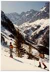
Camping
Hotels, camping places and small pensions abound in the area from Luzern to Göschenen. The base for climbing are the Leutschach and Krönten huts. I am not sure if camping is allowed near these huts, so inquire ahead of time.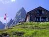
This area is popular and reservations are advised.