
-
 30519 Hits
-
 91.2% Score
-
 35 Votes
|
|
Area/Range |
|---|---|
|
|
46.64147°N / 8.41731°E |
|
|
Hiking, Mountaineering, Bouldering, Skiing |
|
|
11906 ft / 3629 m |
|
|
Introduction
Uri Alps
The Uri Alps - Urner Alps in German - are a mountain range belonging to the Western Alps and mainly located in the Uri district, hence the name, in central Switzerland. The Uri Alps are composed of two distinct groups separated by the Susten Pass: in the Northern part, culminating with the Titlis, the summits are lower but the extension is greater, while the Dammastock massif to the South is more covered with glaciers. The highest peak of the area is the Dammastock with 3629 meters. The Uri Alps are famous in reason of their beautiful granite that can stand comparison with the Mont Blanc or the Bergell granite. The great Rhone river finds its source in the glaciers of the Urner Alps.

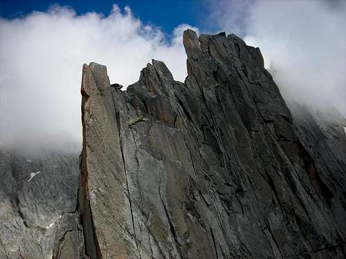
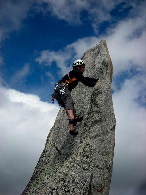
The earth has formed many jagged ridges and sharp peaks in these mountains which offer both plaisir or extreme rock climbs. Most famous plaisir route is maybe the Salbitschijen S-grat. The most famous extreme ridge and maybe on of the most beautiful ridges in the Alps is the on the same mountain: the Salbitschijen W-ridge.
The approach to this area is very varied, being possible to avoid glacier travel and still do some awesome rock-routes or to cross glaciers for as long as you want. In fact the area is not only famous for it's rockclimbing possibilities in the summer but also for skitouring in the winter. The ascent from the Furkapass to the Dammastock is one of the most popular ski tours in the Alps.
The group described on this page (which follows the geographical boundaries) is located between the three most popular passes is Switzerland: Sustenpass to the North, Furkapass to the South and Grimselpass to the West. The east boundary is formed by the Reuss valley. Some people consider the Uri Alps group as a bigger group bordered by the Vierwaldstätter See in the north, the Reuss valley in the east, the Furka- and Grimselpasses in the south and the Brünigpass in the west. Many mountains that fit in the latter category are attached to this site but do not consist of the compact granite of the central Uri Alps.

|

|
Overview of subgroups

1. Gelmerhörner-Tieralplistock-ridge 2. Dammastock-ridge 3. Galenstock-ridge 4. Tierberg-ridge 5. Gletschhorn-Schöllenen-ridge 6. Sustenhorn-Bergseeschijen-ridge 7. Fleckistock-ridge 8. Salbitschijen
Getting There

You can reach the group from many different directions:
- From North: Luzern > A2/E35 > Sustenpass (exit Wassen) or Furkapass (exit Andermatt)
- From East: Disentis / Müster > N19 > Andermatt
- From South: Milano > A8/E35 > A9/E35 > A2/E35 (Switzerland) > Andermatt
- From West: Thun > A8 > Innertkirchen
Red Tape
No fees no permits required. Most passes are closed from November till May.
When to Climb
Climbing and Hiking: July-October If the weather is really hot in spring it may be possible to do some ridges in june.
Skiing: March-June
Camping & Sleeping
Huts:
| Name | Ridge | Bewartet | Tel. number |
| Gelmerhütte | Gelmerhörner-Tieralplistock | July - September | 033 973 11 80 |
| Windegghütte | Gelmerhörner-Tieralplistock-Tierberg | Spring - Fall | 033 975 11 10 |
| Trifthütte | Gelmerhörner-Tieralplistock-Tierberg | March - September | 033 975 12 28 |
| Albert-Heim hütte | Galenstock-Gletschhorn-Schöllenen | June - Oktober | 041 887 17 45 |
| Sidelenhütte | Galenstock | June - Oktober | 041 887 02 33 |
| Dammahütte | Dammastock | July - September | 041 885 17 81 |
| Tierberglihütte | Tierberg | July - September | 033 971 27 82 |
| Chelenalphütte | Tierberg-Sustenhorn | June - Oktober | 041 885 19 30 |
| Bergseehütte | Sustenhorn-Bergseeschijen | June - Oktober | 041 885 14 35 |
| Voralphütte | Sustenhorn-Fleckistock | 041 870 88 34 | |
| Salbithütte | Salbitschijen | June - Oktober | 041 885 14 31 |

|

|

|

|

|

|
Campsites:
Zeltplatz Matli - Göscheneralp
1. Gelmerhörner-Tieralplistock-ridge
Description: This area boasts some excellent mid-grade rock climbs, for example the traverse of the Chli and Grosses Gelmerhorn, traverse of the Gelmerspitzen, the Burg NW-ridge. More difficult rock routes are to be found on Gelmerspitze V, VI and VII and the Gärstenhorn. In the winter the area around the Trifhütte offers a lot of skitouring possibilities to the main-ridge. Maps: Guttanen 1230 1:25.000 Urseren 1231 1:25.000 Sustenpass 255 1:50.000

|

|
Summits
| Name | Height (m) | Comments |
| Vorderes Gärstenhorn | 3166 | |
| Mittleres Gärstenhorn | 3189 | |
| Hinteres Gärstenhorn | 3172 | |
| Schoibhoren | 2683 | |
| Gelmerhörner | 3317 | |
| Alpliturm | 3043 | |
| Burg | 2598 | Not in Landeskarte |
| Tieralplistock | 3383 | |
| Diechterhorn | 3389 | |
| Gwächtenhorn | 3214 | |
| Ofenhoren | 2493 | |
| Mittagflue | 1865 | |
| Wyler- und Bottiger-Dümen | 1642 | |
| Bänzlauistock | 2529 | |
| Brunnenstock | 2519 | |
| Graustock | 2689 | |
| Mährenhorn | 2922 | |
| Steinhüshorn | 3121 | |
| Chilchlistock | 3114 |
Passes
| Name | Height (m) | Comments |
| Obri Triftlimi | 3101 | Rhoneglacier / Triftglacier |
| Undri Triftlimi | 3075 | Rhoneglacier / Triftglacier |
| Gelmerlimi | 3000/3100 | Handegg / Rhoneglacier, E one is the best. |
| Diechterlimi | 3215 | Diechtertal / Triftglacier |
| Gwächtenlimi | 3100 | Gelmerhütte / Trift- & Windegghütte |
| Üssri Garwydilimi | 2685 | Guttanen / Diechtertal |
| Indri Garwydilimi | 2684 | Guttanen / Diechtertal |
| Furtwangsattel | 2568 | Rindertal / Trifttäli |
| Chichlilimi | 2952 | Rotlauital / Triftglacier |
2. Dammastock-ridge
Description: This area is home of the highest summit of the area: the Dammastock. This area is unlike some other areas in the Uri alps not so much the domain of the alpine rock climber but more of the general alpinist. The east flanks of the ridge from Tiefenstock to the Dammastock offer beatiful combined outings. In the winter some tours are to be made from the Rhone glacier, for example to the Eggstock, Rhonestock and Dammastock. Maps: Urseren 1231 1:25.000 Sustenpass 255 1:50.000

|

|

Summits
| Name | Height (m) | Comments |
| Tiefenstock | 3515 | |
| Vorderer Rhonestock | 3566 | |
| Hinterer Rhonestock | 3596 | |
| Dammastock | 3629 | |
| Scheestock | 3608 | |
| Eggstock | 3583 | |
| Moosstock | 2611 | Bad weather alternative |
| Dammaplatten | 2811 | Bad weather alternative |
Passes
| Name | Height (m) | Comments |
| Tiefensattel S | 3406 | Between Galenstock and Tiefenstock |
| Tiefensattel N | 3335 | Between Galenstock and Tiefenstock |
| Unteres Winterjoch | 3425 | Between Tiefenstock and Vorderem Rhonestock |
| Oberes Winterjoch | 3525 | Between Vorderer- and Hinterer Rhonestock |
| Rhonejoch | 3519 | Between Rhonestock and Dammapass |
| Dammapass | 3525 | Between Rhonestock and Dammastock |
| Dammajoch | 3560 | Between Dammastock and Scheestock |
3. Galenstock-ridge
Description: This is an area with excellent ridge climbs, both on rock or in combined terrain. Examples in rock are the Gross Bielenhorn SE-ridge and the Chli Bielenhorn SW-ridge. The Galenstock offers the excellent SE-ridge. Maps: Urseren 1231 1:25.000 Sustenpass 255 1:50.000

|

|
Summits
| Name | Height (m) | Comments |
| Klein Furkahorn | 3026 | |
| Gross Furkahorn | 3169 | |
| Galengrat | P. 3235 offers some great climbing. | |
| Galenstock | 3583 | |
| Gross Bielenhorn | 3206 | |
| Chli Bielenhorn | 2940 | |
| Hannibalturm | Hannibalturm offers nice moderne routes |


Passes
| Name | Height (m) | Comments |
| Sidelengratlücke | 2980 | Rhoneglacier / Sidelenglacier |
| Sidelenlücke | 3120 | Rhoneglacier / Sidelenglacier |
| Obere Bielenlücke | 3225 | |
| Mittlere Bielenlücke | 2980 | |
| Untere Bielenlücke | 2900 | Albert Heim hütte / Sidelenhütte |
4. Tierberg-ridge
Maps: Guttanen 1230 1:25.000 Innertkirchen 1210 1:25.000 Meiental 1211 1:25.000 Sustenpass 255 1:50.000

|

|
Summits
| Name | Height (m) | Comments |
| Sunnighoren | 2412 | |
| Radlefshoren | 2603 | |
| Graue Stöckli | 2776 | |
| Drosistock | 2822 | |
| Giglistock | 2900 | |
| Brunnenstock | 2763 | |
| Vorder Tierberg | 3091 | |
| Mittler Tierberg | 3311 | |
| Hinter Tierberg | 3447 | |
| Maasplangstock | 3401 |
Passes
| Name | Height (m) | Comments |
| Steinlimi | 2734 | Steinglacier / Windegg- & Trifthütte |
| Tierberglücke | 2986 | Tierberg- & Chelenalphütte / Triftgletscher |
| Chelenlücke | 3203 | Chelenalp / Tierberghütte |
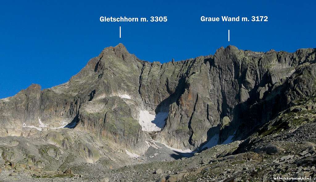
5. Gletschhorn-Schöllenen-ridge
Maps: Urseren 1231 1:25.000 Sustenpass 255 1:50.000
Summits

| Name | Height (m) | Comments |
| Gletschhorn | 3305 | |
| Graue Wand | p. 3172 | |
| Winterstock | 3203 | |
| Lochberg | 3074 | |
| Blauberg | 2955 | |
| Müeterlishorn | 3066 | |
| Hinter Feldschijen | 3021 | |
| Vorder Feldschijen | 2962 | |
| Mittagstock | 2989 |
6. Sustenhorn-Bergseeschijen-ridge
Maps: Urseren 1231 1:25.000 Meiental 1211 1:25.000 Sustenpass 255 1:50.000
Summits


| Name | Height (m) | Comments |
| Sustenspitz | 2930 | |
| Chli Sustenhorn | 3318 | |
| Sustenhorn | 3203 | |
| Vordere Sustenlimihorn | 3316 | |
| Brunnenstock | 3210 | |
| Voralphorn | 3203 | |
| Chelenalphorn | 3202 | |
| Hoch Horefellistock | 3021 | |
| Schijenstock | 3161 | |
| Bergseeschijen | 2815 | |
| Hochschijen | 2634 | |
| Gandschijen | 2388 | |
| Gwächtenhorn | 3420 |
7. Fleckistock ridge
Maps: Meiental 1211 1:25.000 Sustenpass 255 1:50.000
Summits
| Name | Height (m) | Comments |
| Chli Griessenhorn | 2851 | |
| Gross Griessenhorn | 3202 | |
| Stucklistock | 3308 | |
| Fleckistock / Rot Stock | 3416 | |
| Chüeplanggenstock | 3207 | |
| Rorspitzli | 3220 | |
| Spitzli | 3011 |
8. Salbitschijen
Maps: Meiental 1211 1:25.000 Urseren 1231 1:25.000 Sustenpass 255 1:50.000
Summits
| Name | Height (m) | Comments |
| Salbitschijen main summit | 2981 | |
| Salbitzahn | 2728 | Lowest tower in the S-ridge |
| Plattenturm | 2900 | Tower in S-ridge |
| Zwillingsturm | 2920 | Tower in S-ridge |
| Meiggelenstock | 2448 | |
| Meiggelenplatte | 2405 | |
| Meiggelengrat | 2512 |
Meteo
Guidebooks and Maps
Books:
- Clubführer Urner Alpen. Bd.2, T. Fullin & A. Bahnholzer, ISBN: 3-85902-222-9
- Schweiz Plaisir Ost, J. von Känel, ISBN: 3-906087-15-8
- Salbit Erleben, H. Berger, ISBN: 3-906087-21-2
Maps:
Landeskarte der Schweiz: 1:25.000:
- 1210 Innertkirchen
- 1211 Meiental
- 1230 Guttanen
- 1231 Urseren
- 255 Sustenpass 1:50.000
Useful resources
Planning tools:
General: Basislager.ch - Actual winter and summer conditions Swiss Avalanche Forecast Weather: Swiss Webcams Weather Radar Live Cam Five Day Forecast
Swiss Mountain Rescue: REGA In Switserland call 1414 fo help.
Useful telephone numbers: 117 Police 118 Fire Department 144 Ambulance
General Information: 1811 Adress information on doctors i.e.. 140 Road Rescue (like ADAC, ANWB etc.) 162 Weather Bulletin 163 Traffic Information 187 Avalanche Bulletin