
-
 14458 Hits
-
 74.01% Score
-
 4 Votes
|
|
Mountain/Rock |
|---|---|
|
|
34.71283°N / 98.70173°W |
|
|
Comanche |
|
|
Hiking |
|
|
Spring, Summer, Fall, Winter |
|
|
1865 ft / 568 m |
|
|
LOBO MOUNTAIN
Lobo Mountain (1865 ft) is a somewhat unnoticed little mountain, tucked away on the western edge of the Dog Run Trail System of the Wichita Mountain Wildlife Refuge. It is a great little mountain for a short, not too strenuous climb or a family outing. (Class 1,2, maybe a little 3) With young children the entire hike to the top and back to the parking lot can be done in less than 2 hours. CAUTION: Even though young children can do this easily, there are places that are steep and almost verticle. Children should always be under the supervision of an adult(s).
There are two noticible high points on the top of Lobo Mt, the south peak appearing to be the highest peak. From the summit, looking westward, you have a commanding view of Bat Cave Mountain, Bat Cave Peak, Mt Lincoln, and the eastern side of Elk Mountain. To the NW you can also see Mt Pinchot, the highest point in the WMWR at 2479 Ft Elevation. To the east can be viewed Mt Scott and Mt Marcy.
Lobo Mountain is not labeled on the Wichita Mountain Wildlife Refuge Topo maps. It is shown on the pullout map in the back of the book "Outdoor and Trail Guide to the Wichita Mountains" by Edward Charles Ellenbrook.
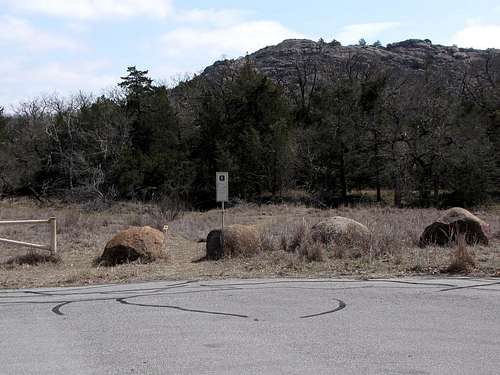 Lobo Mountain from the south Dog Run Hollow Trail parking lot.
French Mountain
Immediately across the small valley to the east-northeast of Lobo Mountain is another somewhat obscure rise known as French Mountain (Elevation 1775 Feet). French Mountain, with it's wooded flanks and tree cover, lies between Lobo Mountain and the French Lake Water System and is labeled on the WMWR topo map. There are no known trails to the summit of French Mountain. Easy access can be from the same Dog Run Hollow trail mentioned above. Follow the Dog Run Hollow Trail into the clearing area and just past Lobo Mt on the right. When you come to a fork in the trail take a left turn back towards the NNW. Continue until you come to a small lake on the right. At the lake, leave the trail and follow an east/south-east route through the trees. Look for areas of clearing where you can navigate the trees. After a walk of about 10 minutes you should see a long ridge extending in a NNW to SSE direction. This is French Mountain. Look to the right side of the ridge for an area of clearing with and outcropping of rocks and boulders. You can follow this rocky clearing all the way to the top. Remember, French Mountain is not very high or prominent. Because of the thick tree covering, you have to be almost to the ridge before you can see it. Once you reach the summit, look for a large boulder with an Army Corp of Engineers Triangular Station Marker.
Another way to reach French Mountain is to park at the north trailhead. (See Map Image) Follow trail to the SE until you reach the lake and then follow above directions.
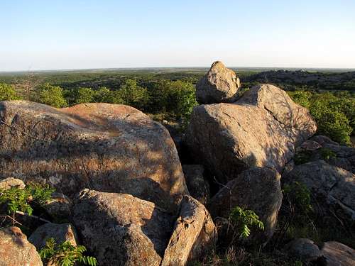 Summit of French Mt
Getting There...
From Lawton OK:
If you are visiting the Wichita Mountain Wildlife Refuge from the Lawton area, you will most likely enter the park on Rt 49 from the H.E. Bailey Turnpike (I-44). It is approximately 8 miles from I-44 to the park. Once in the park continue on Rt 49 West passing the turnoff to Meers OK (Rt 115). Shortly after you pass the Visitor Center Rt 49 will turn to the right and continue westward through the refuge. Turn left (South) toward the Refuge Headquarters (Indiahoma Road). After passing the Refuge Headquarters, continue to the second Dog Run Hollow trail turnoff. Turn left and drive a short distance to the trailhead parking lot. Begin the hike on this trail through the trees. Lobo Mountain will be to the right of the trail (south) as you continue eastward. Upon reaching a clearing area you will leave the trail and hike toward Lobo Mountain. Depending on the actual path that you take you may see one of the many open verticle mines located in the WMWR. The mine is just a short distance from the trail. (See Map image for further information.)
From Cache OK:
From US Rt 62, take Rt 115 N from Cache. It is about 6 miles from Cache to the WMNWR gate. Follow Rt 115 to Rt 49. Continue west on Rt 49 until you reach the turn off to the Refuge headquarters (Indiahoma Road). Refer above paragraph for further details.
From the WEST ENTRANCE:
Enter the Wichita Mountain Wildlife Refuge on Rt 49. Continue east past the Sunset turnoff. Look for the turnoff to the Refuge Headquarters. Turn right (Indiahoma Road) and continue south. (Refer to first paragraph in this section for further details.)
DISTANCE to the Wichita Mountain Wildlife Refuge from various cities:
Amarillo TX, 214 miles
Dallas TX, 205 miles
Fort Smith AR, 263 miles
Oklahoma City OK, 86 miles
Tulsa OK, 191 miles
Wichita KS, 246 miles
Wichita Falls TX, 68 miles
CAUTION:Observe posted speed limit signs, especially at night. Park authorites will ticket you for violations. I know from first hand experience!
Heart Rock
Heart rock is a natural formation located a very short distance from the Indiahoma Road. I mention it here because, although it is on the opposite side of the road from Lobo Mt, it is a very short distance from the Dog Run Hollow turnoff.
To find Heart Rock, drive south on the Indiahoma Rd passing the Refuge Headquarters, the French Lake turnoff, the Fawn Creek turnoff, and the Dog Run Hollow turnoff. After passing the Dog Run Hollow turnoff, park on the first turnout on the left side of the road. Walk across the road and look for two narrow trails through the trees. Either trail will take you to Heart Rock. The trail on the right will take you up on a large rock slab. Once you are up on the slab, look to your left and down to find Heart Rock. The heart shape will be more realistic when viewing from the rock slab above.
You can also take the left trail through the trees which will take you right to the base of Heart Rock. (Refer image Below)
Camping
The Wichita Mountains Wildlife Refuge offers a fully developed camping facility.
Doris Campground is located about 1 1/2 miles to the west of the Visitor Center. This campground is fully developed with water, fire grills, picnic tables, sanitary dump stations, shower & restroom facilities, tent sites, some electrical hookups, and trailer spaces. Sites are first come - first served. There is limited group camping by reservation only. Fees are charged.
Backcountry camping (by permit only) is available in the Charon's Garden Wilderness Area further to the west.
Red Tape
There is no fee to visit the Wichita Mountain National Wildlife Refuge. There are several picnicking areas throughout the park. There are opportunities for general camping, backcountry camping (Permit only) and there are numerous trails for hiking and backpacking. Boating is permitted but there are special rules that apply. Fishing is in accordance with state and federal regulations. Hunting is by lottery through the OK Department of Wildlife Conservation. There are tours and special programs provided by the park service. For specific rules and regulations and/or additional information, please check with the WMNWR Visitor Center or visit the site below.
U.S. Fish and Wildlife Service,Wichita Mountains Wildlife Refuge
Route 1, Box 448, Indiahoma, OK 73552 (580) 429-3222
Hiking Health and Safety
Depending on what season of the year that you hike in the Wichita Mountains you may need to be concerned with ticks, chiggers, and other potential insect threats. Insect repellent is always a good idea. Upon returning home, be sure to wash your clothes and check your body for ticks. They will often show up a day or two later. Always treat any insect bite with concern. If sickness, fever, aching, etc, follow an insect bite you should seek your doctors care.
Beware of the animals in the refuge. Buffalo and Longhorn Steer can be dangerous if cornered or threatened. Snakes are also plentiful. Always be alert and aware of your surroundings. Remember, a good hike is a safe hike.
External Links...
WICHITA MOUNTAINS WILDLIFE REFUGE Website
Witchita Mountains Geology