
-
 24404 Hits
-
 87.31% Score
-
 24 Votes
|
|
Mountain/Rock |
|---|---|
|
|
34.71276°N / 98.72164°W |
|
|
Hiking, Scrambling |
|
|
Spring, Summer, Fall, Winter |
|
|
2201 ft / 671 m |
|
|
Overview
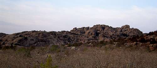
Mount Lincoln on the approach from the group camp
Mount Lincoln is the second highest peak in the Wichita Mountain's Charon's Garden Wilderness. The Wichitas are Oklahoma's finest hiking and climbing destination. The massive granite peaks and domes stand in sharp, pink contrast to the horizontal yellow of the surrounding plains. Whichever direction one comes from, miles of flat plains have to be covered to get to the Wichitas. Their dark mass looming on the horizon is always an exciting site, a harbinger of the rugged, chaotic wilderness of rock, drawing in those in search of the vertical.
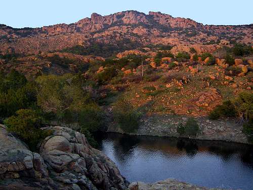
Mount Lincoln from Treasure Lake
Mount Lincoln is the dominant peak in the southeast corner of the Charon's Garden Wilderness. It is typical of many of the summits in the Wichitas: craggy, boulder strewn, pink granite domes rising above forests of juniper and post oak. Closer examination reveals that Mount Lincoln is the highest point on a massif that contains also contains three other named peaks. Bat Cave Mountain, Bat Cave Peak and Phantom Mountain are all located at the southern end of the Mount Lincoln Massif and of the three, only the informally named Bat Cave Peak exceeds 2,000 feet. The most distinctive feature on Mount Lincoln is the pair of massive, house-sized boulders located just below the summit. Nearly as tall as the mountain itself, these huge rocks form a peculiar facade from most of the perspectives Mount Lincoln is viewed.
Summit views from Mount Lincoln are some of the best in the Wichita Mountains. Notably, the summit provides what is perhaps the best vista of nearby Elk Mountains expansive southern wall, home to numerous excellent climbing routes. To the west, the Charon's Garden Wilderness appears as a massive jumble of chaotic granite domes and and crags. Mount Scott and the eastern end of the Wichita Mountains are also prominent, though 11 miles distant. To the south, the Wichitas melt away into the golden plains of southwestern Oklahoma, stark testimony that the Wichita Mountains is a refuge for more than just wildlife.
Route
Mount Lincoln is generally approached from three directions. The two most common routes are from the west, via a route splitting off of the Charon's Garden Trail. This route has trailheads at the northern and southern end of the wilderness area. More details on Charon's Garden Trail can be found here.Maps
Mount Lincoln Area
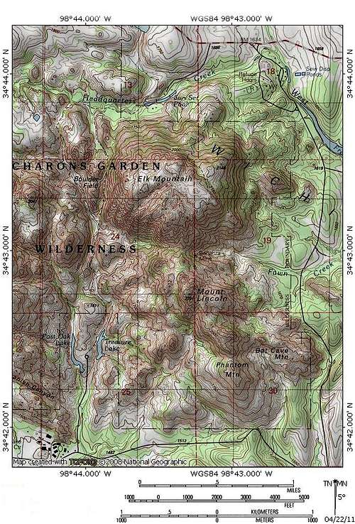
Routes Map
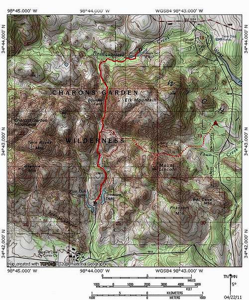
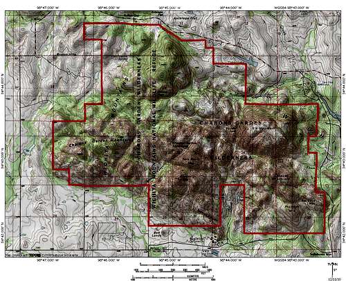
Charon's Garden Wilderness Map
Getting There
From I-44 take Highway 49 (exit 45). Go west 10 miles to the Refuge gate. Proceed through the park, past the visitors and turn right at the stop sign. Continue west and turn left into the Sunset Picnic Area.If coming from Highway 62, take Highway 115 (Cache exit) north to the Refuge Gate. Proceed north. The road will turn west and continue until turning left into the Sunset Picnic Area.
Camping
Camping in the wilderness is by permit only. These can be obtained for $2.00 at the visitors center or by mail. Permits are issued for a maximum of ten people in the backcountry at one time. Only the northern portion of the wilderness is open to camping and no fires are permitted. Watch out for bison and longhorns, since they tend to wander through this area.Doris campground is a few miles away and is a good option if you do want to sleep in the backcountry. Another great option is the group campground on the eastern border of the wilderness. It is much cheaper than the Doris campground and you can head up into the wilderness directly from there if you do not mind some bushwhacking.
Department of the Interior
U.S. Fish and Wildlife Service
Wichita Mountains Wildlife Refuge
R.R. #1 Box 448
Indiahoma, OK 73552
580.429.3222
Refuge Camping Site
Red Tape
Mount Lincoln is located in the Charon's Garden Wilderness Area of the Wichita Mountains Wildlife Refuge. Unlike most wilderness area, this one is administered by the U.S. Fish and Wildlife Service (USFWS). No permits or fees are required to climb, but camping is by permit only. Wilderness rules and ethics apply.Wichita Mountains National Wildlife Refuge
U.S. Fish and Wildlife Service,
Wichita Mountains Wildlife Refuge,
Route 1, Box 448,
Indiahoma, OK 73552
(580) 429-3222.
splandswest - Apr 29, 2010 12:22 pm - Hasn't voted
Crash SiteThe south point of Mt Lincoln was the site of a Saturday, November 30, 1968 plane crash. The plane, a Cessna 310B, alledgely took off from Wichita Falls, TX and was headed northward into Oklahoma. The crash was evidently caused by adverse weather conditions, including fog, snow, and zero visibility. For more information, refer to the Image section of this page.