
-
 30230 Hits
-
 84.44% Score
-
 19 Votes
|
|
Mountain/Rock |
|---|---|
|
|
34.70789°N / 98.7113°W |
|
|
Hiking, Scrambling |
|
|
Spring, Summer, Fall, Winter |
|
|
1855 ft / 565 m |
|
|
Overview
Bat Cave Mountain is located in the southeastern corner of Charon's Garden Wilderness in the Wichita Mountains Wildlife Refuge, OK. It should not be confused with the unofficially named Bat Cave Peak, which is adjacent to Bat Cave Mountain. Bat Cave Mountain is named after the easily seen, but less easily accessed, Bat Cave (sometimes called Wind Cave) located on its southern flake. On its northern side, Bat Cave Mountain also has the easily viewed Arch Cliff Dwelling, which is also known as Natures Dwell. Arch Cliff Dwelling. Imaged by Splandswest.
Getting There
Bat Cave Mountain is most easily accessed from turn-outs along Indiahoma Road. Follow the directions for arrival at the Wichita Mountains Wildlife Refuge located here: Area map.
o SP Wichita Mountain Page -- Getting There
Upon arrival in the Wichita Mountains you will need to drive Indiahoma Road between the Treasure Lake Job Corps Center and the Refuge Headquarters. From the south on Indiahoma Road, you will see Bat Cave Mountain immediately in front of you when the road takes the sharp, north-bound turn. If south-bound, you will see Bat Cave Mountain once you pass the turn off for French Lake (left side) and Fawn Creek Campground (right side). Indiahoma Road actually curves around and hugs the base of Bat Cave Mountain in its journey. There are three turn-outs, one north of the mountain, and two along the east face (on each side of the road). It is 2.3-miles from the turn-off on Highway 49 along Indiahoma Road to these two turn-outs, which are the closest to the base of the mountain. There are trails that lead off in the general direction of the mountain.
Red Tape
There is no charge to visit the Wichita Mountains Wildlife Refuge. Hiking is not allowed at night. Dogs are permitted, but must be on a leash. All forms of alcoholic beverages are prohibited.Camping
There are designated campgrounds that must be used. Backcountry camping is permitted in Charon's Garden, but not in this immediate area and not without a permit. For additional information on camping and lodging, visit the Wichita Mountains page:o SP Wichita Mountains Page -- Camping and Lodging
 Pothole ecosystems on the summit; Mt. Lincoln in the background.
Climbing and Hiking
SummitingBat Cave Mountain has no specific trail to the summit. Rather, the hiker is expected to use a combination of bushwhacking and bouldering to climb to the top. There are three turn-outs along Indiahoma Road, and any will provide several trails that head off in the general direction of the mountain. Two of the turn-outs (across the road from each other) are very close to the east face, providing the easiest access to the mountain. Quickly those trails will disappear as the hiker crosses over to the granite rock that forms the bulk of the mountain. Basically, the hiker picks out a line that suits his skill and fancy and strikes out for the top. While not a Class 1 trail by any means, no particular technical skill is required.
 One of many possible routes to the top. The arrow points to Bat Cave.
Technical Climbing/Rappelling
Natures Dwell, which is easily seen during the drive to the mountain from the north, provides the opportunity for about a 60 foot rappel, including about 30-feet of free rappel across the large opening. The landing is slanted, so exercise extreme care when exiting a rappel.
Bat Cave, for which the mountain is named, is inaccessible without either a ladder (from below), or some technical skill (from above), including the recommended use of technical gear.
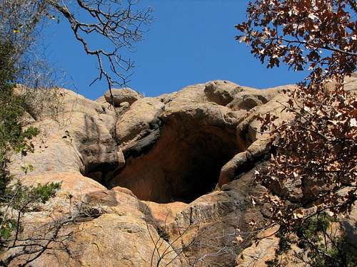 Bat Cave. Imaged by Splandswest.
Additional Information and External Links
For additional information on the Wichita Mountains Wildlife Refuge, check out the links here:o SP Wichita Mountain Page--Additional Information
o SP Wichita Mountain Page--External Links
Bat Cave Mountain is on the USGS Quanah Mountain quad topo. A high resolution, digital version of the map is available under the Creative Commons License here:
o Quanah Mountain USGS Quad Topo