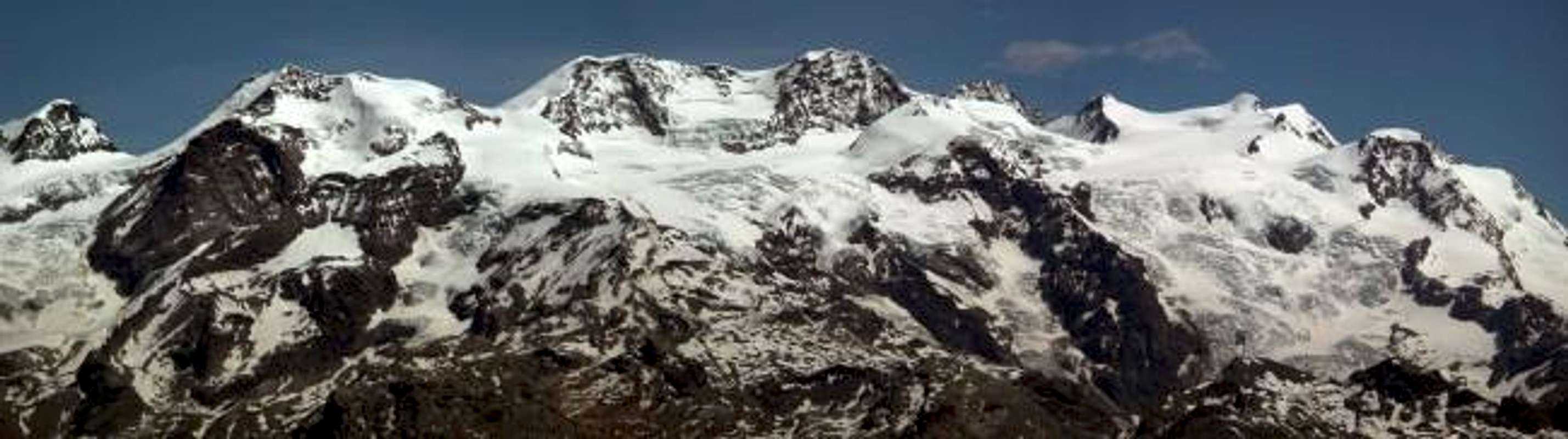
The whole Monte Rosa Group seen from Monte Zerbion: from left side: Polluce, Castore, Lyskamm, Dufour, Zumstein, Gnifetti (Margherita Refuge), Parrot, Cristo delle Vette, Piramide Vincent, Punta Giordani. This mountain is located between the Ayas Valley and the Valtournenche Valley; is very easy to hike, there are some paths; is also a wonderful place to make ski mountaneering. From the top, due is central position, there is a very wide view on all the most important summits of the Aosta Valley, Gran Paradiso Group, Monte Bianco Group, Cervino, Monte Rosa Group. This top is exactly above Saint Vincent, and is one of the top that you can see driving along the motorway, behind the Montjovet Castle; in the top there is a very big statue of the Virgin.
Getting There
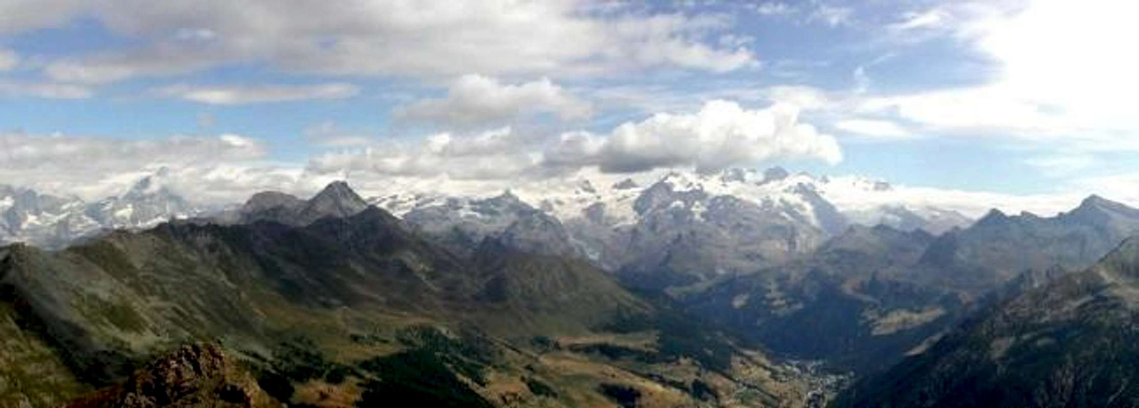
Follow the motorway Torino-Aosta, exit Verres; the next indication is Val d'Ayas; after a few kilometers, turn left following the sign Antagnod (very nice church year 1497, national monument), and here follow the indication Barmasc; in Barmasc you can park; there is a Chapel year 1580, fest the 3 of August if it's Sunday, or the next Sunday. In Barmasc, (1.828m), you will find the yellow sign with the indication Monte Zerbion, 2h'15 hours. The path is very nice, sometime steep, and crosses, after a wile, a quiite wide channel named Ru Cortod; this is the most important irrigation channel built in Aosta Valley; is 20 km long, collects the waters of a small river in the Cime Bianche deep valley, above Champoluc St. Jacques, and brings its to the col di Joux; having time, in summer or spring is very intersting to follow, with a trial of 6/7 hours, very easy. Take care: no more water after this point. After the small bridge, the path is in a bush of pick pines; the last part of the path, that you simply hike, brings to the Portola Pass, (2.415m). Despite the 600m of level from the beginning, usually you reach the pass in a quite short time, the path from a certain point is very steep. The view on the Ayas valley is magnificent; from the pass you see also the other face of the mountain. Turn left, and follow the path that from this point cross the north west side of the mountain. Hiking, the view enlarges: you have in front the summits of the central Aosta Valley, and as soon as you arrive on the wide ridge, on your left and behind you, appear the whole Monte Rosa Group and the Cervino; when you arrive to the top, it seems that you can touch these mountains with your hands. I suggest to hike this mountain in a sunny day; to loose the overview from the top is a pity!!
Red Tape
No permits or rescrictions.
Routes
From South: from Chatillon Municipality, with Municipal Road in Northeast on Chatillon High Hill, towards Merlin/Cret Blanc, Chavod, Pissin/Albard/Closel, Domianaz to Nissod Villages (1.371m); from this, through dirt farms road in North-northeast, to Nuarsaz Alp, below Southern slopes of Mount Zerbion (1.713m; T/E; 1h'00/1h'15 from Nissod). Continue West from Nuarsaz Alp, with dirt road, to Chesalet (1.735m), Jacquémin-Giacomet (1.777m) Alpages; from this, through path in North, to grassy great Shoulder 1.991 meters (wooden benches on a grassy flat promontory) between Franquin/Varé Woods at the beginning of Western easy and grassy Crest Mount Zerbion. Through small path-traces to Summit (F+/M-; 2h'30/2h'45, from Nuarsaz Alp; 4h'30/5h'00, from Nissod Village). From Northwest: from Antey Saint André-Petit Antey (1.092m) with Municipal Road towards Chaillein, Noussan (1.509-1.474m) Villages, alternative 1.307 meters, neighbor Dalai Lama Camping (1.499m) to Promiod important Hamlet (+; 1.505m). From this, through dirt road in Northeast, towards Boettes (1.722m) Pasture, Supplin (1.914m), Brovié (1.908m), Renard (2.046m) Alpages, forks 2.118, 2.165, 2.252 and 2.354 meters to Portola Hill through Western slopes (2.414m; E/F; 2h'00/2h'15), between Mont Tantané/Mont Zerbion on watershed Valtournanche/Ayas Valley. From the hill via the following route departing from Brusson you reach the Summit (E/F; 0h'40/0h'50, by pass; 2h'50/3h'10 in total).
Variants: a) - starting with the same result can also connect with the first route, or by using the South Slope (Nissod Village). From the crossroads 1.940 meters on the private dirt farms road to the Col Portola, leave this and go to the Southeast; twice forded the secondary torrent that comes from the pond 2.201 meters, you will reach the Alp Champ (2.014m) at the edge of the Bois (Wood) de la Nuova. From this point the same turns in the Southwest reaching Alps Francou Damon and Dèsott (2.044m, 2.021m) below Bois de Franquin, where, finishing, gives way to a good path that reaches towards the Southern grassy shoulder junction in the previous 1.991 meters away from Nissod (EE; calculate 0h'50/1h'00 from the junction to the shoulder and an other at Summit). Also
b) - on same dirt private road from alternative 1.722 metres, just after Boettes Pasture, with an other dirt farms before in East to Arsine Alp (1.844m), after South to fork 1.995m, immediately after Francou Dèsott, and previous route to Top (same time). From Northeast: from Brusson, Vollon, Extrapierre, Corbet (+; 1.510m) with Main Road and towards, Ravines (1.497-1.516m; Alpine Holiday Camp), Lignod (+; 1.615m), Antagnod (+; 1.684m), neighbor Ayas Commune (1.696-1.738m), through Regional Road. From Antagnod, with path in West-southwest, towards small village 1.840 meters, Barmasc Village (+; restaurant; parking 1.898m; even Municipal Road from Antagnod), crossing among Borbey/Tantané/Arpeillaz Woods, alternative 1.970 meters above Ru Cortot to
1) - Portola Hill (2.414m; 1h'15/1h'30 from Barmasc Village; 2h'00/2h'15 from Antagnod Hamlet or, with path, from Lignod, Borbey Villages (1.862m), between Mont Tantané/Mont Zerbion. From Hill to
2) - Zerbion, through North Ridge "Way of the Passion of Christ" with various memorial tablets and a small private shelter, (+; 2.720/30m; 1h'00/1h'30).
When To Climb
In spring summer, it depends on the season; the final ridge with the snow can crate some problems to the persons that are used only to hike. The best time is from June to October, despite you can reach the top even later on, if there is not jet snow. Ski mountaneering: from the first snow to middle April, depending on the season; the way is not this one, follow the north west side, and is recommended after fresh snow, powder due to the exposition!!!
Campings
In Aosta Valley you can camp only over 2.500 meters. In Val d'Ayas there are a few Campings; one is just a few kilometers before Antagnod.
Mountain Conditions
You can get meteo information at the official site of the Regione Valle d'Aosta:
Children refers to the set of objects that logically fall under a given object. For example, the
Aconcagua mountain page is a child of the 'Aconcagua Group' and the 'Seven Summits.' The
Aconcagua mountain itself has many routes, photos, and trip reports as children.
Parents refers to a larger category under which an object falls. For example, theAconcagua mountain page has the 'Aconcagua Group' and the 'Seven Summits' asparents and is a parent itself to many routes, photos, and Trip Reports.

 14540 Hits
 87.31% Score
 24 Votes