
-
 14919 Hits
-
 83.69% Score
-
 17 Votes
|
|
Mountain/Rock |
|---|---|
|
|
38.01360°N / 107.75299°W |
|
|
Ouray |
|
|
Hiking, Mountaineering |
|
|
Spring, Summer, Fall, Winter |
|
|
13468 ft / 4105 m |
|
|
Overview
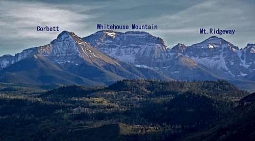 Whitehouse Mountain and Mt. Ridgway as seen from the north
 The views from its summit are spectacular, especially over Sneffels Range.
Guide to the Colorado Mountains with Robert Ormes (sort of a bible for Colorado Mountains) does not offer much information. "From East Blaine Basin, attempts can be made up the eastern end of the cirque on Mount Ridgway (13,468'), known as S2 to the SJM, or to the top of the ridge extending 0.7 mile northwest of Ridgway called Reconnoiter Peak (12,960') by climbers." Truly a brief description, but I know where is S2 now. I was searching for that one. Reconnoiter Peak really caught my interest. I felt slobbering like Pavlov's dogs when spotted Reconnoiter.
Colorado Rank: 275
Class: 2
Parent Lineage: Teakettle Mountain
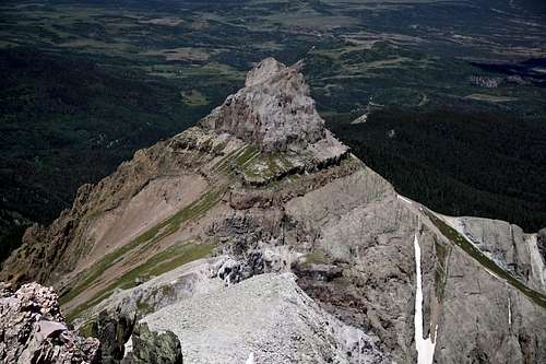
![East Ridge of Mt. Ridgway]() East Ridge of Mt. Ridgway
East Ridge of Mt. Ridgway![East Ridge Ridgway]() East Ridge Ridgway with Whitehouse Mountain in the backgroundMany different route options exits. The mountain combines really nicely with Whitehouse.
East Ridge Ridgway with Whitehouse Mountain in the backgroundMany different route options exits. The mountain combines really nicely with Whitehouse.
Nearby Peaks:
Whitehouse Mountain 13,492 feet 0.93 miles
Teakettle Mountain 13,819 feet 1.02 miles
"Coffeepot" 13,568 feet 1.22 miles
Cirque Mountain 13,686 feet 1.23 miles
"Corbett Peak" 1.39 miles
Potosi Peak 13,786 feet 1.66 miles
"Kismet" 13,694 feet 1.98 miles
Mt. Sneffels 14,150 feet 2.24 miles
Gilpin Peak 13,694 feet 2.89 miles
Mount Emma 13,581 feet 3.26 miles
Views from the summit of Mount Ridgway
 Potosi Peak
 | 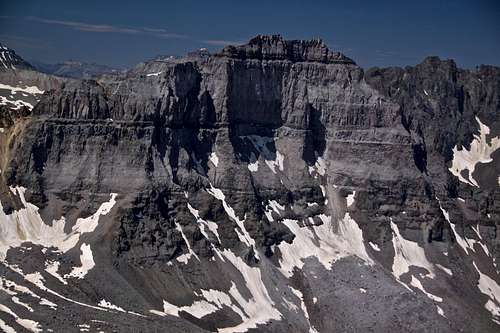 Cirque Mountain
 |
 Mt. Emma and Lizard Head
 | 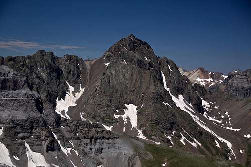 Mt. Sneffels and Kismet (on the left)
 |
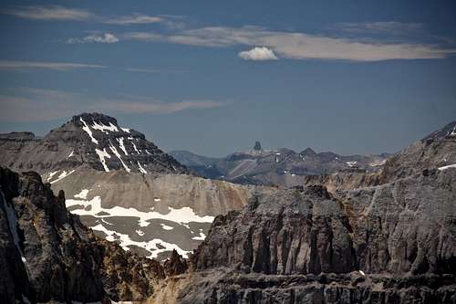
 Reconnoiter Peak
 | 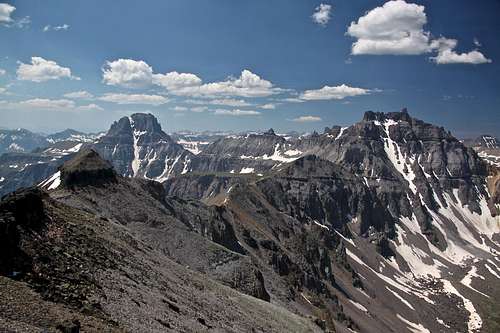 South Ridge of Mount Ridgway with Teakettle on the right and Potosi on the left
 |
Getting There
From Ouray drive south and take the turn off for Camp Bird Road and Yankee Boy Basin (county road 361). The road goes over Uncompahgre Gorge Bridge (= Ice Park in the winter). Continue on a well maintained gravel road, open even during the winter for about 3 miles. Shortly after a bridge spanning Canyon Creek look for Weehawken Trailhead on the right side - it is well marked. There is a small parking lot. You do not need 4WD to reach this spot.Route
 East Ridge of Mt. Ridgway
 East Ridge Ridgway with Whitehouse Mountain in the background
I chose an approach via Wheehawken Trail, partly because I wanted to stay on the trail and avoid scree as much as possible. It is possible to approach Mount Ridgway also from Blaine Basin from the north (more scree hiking). No matter which approach you choose, expect to hike at least 10 miles round trip.
Wheehawken Trailhead is located at 8,740 feet and is popular in the summer with hikers. I am writing popular, but when I hiked it on Saturday I met only one person. I have skied this trail in the winter also. The trails starts climbing pretty quickly right from the parking lot, and initially is easy to follow. It winds along the eastern side of Potosi Peak and brings you eventually to a beautiful Wheehawken basin. Here the trail becomes less obvious and is easy to loose it, but route finding did not appear to be a problem. Pass the cliffs on the north side and continue higher through Wheehawken Basin until the slopes with some trees bring you into a higher basin above 12,000 feet. You are now above the trees and can see Mount Ridgway - at least its false summit. Here you have to decide whether your want to climb the East ridge or South Ridge.
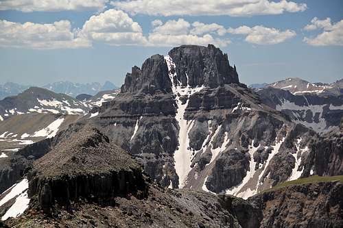
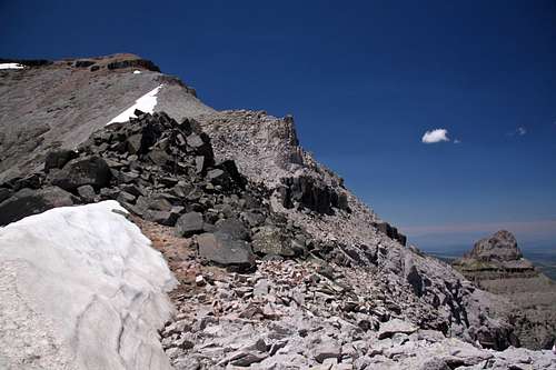
East Ridge: Head towards Mount Ridgway and Whitehouse Mountain saddle through the basin, onto another basin. There is a faint trail here and there. You have to cross a small creek. Enjoy the views, especially North Couloir of Potosi Peak looks amazing. The basin above the cliffs is > 12,000 feet and you can see Mt. Ridgway, but not its true summit (that is hiding). ![The summit of Mount Ridgway]() The summit of Mount Ridgway
The summit of Mount Ridgway![Reconnoiter Peak]() Reconnoiter PeakEast Ridge is I think slightly easier and great for connecting Mount Ridgway with Whitehouse. There appears to be a faint trail going up the Whitehouse - Ridgway saddle, and it is not that steep. If Ridgway is your only destination take the first gully west of this saddle straight up. This will bypass Point 13,150 feet. The gully has some scree, but the going was no so bad.
Continue on Ridgway's east ridge on some semi stable talus. Look north - amazing view of Reconnoiter Peak 12,960 feet. Its height does not attract many climbers, but the peak is spectacular. This East Ridge route is ~ 10 miles round trip and almost 5,000 feet elevation change.
Reconnoiter PeakEast Ridge is I think slightly easier and great for connecting Mount Ridgway with Whitehouse. There appears to be a faint trail going up the Whitehouse - Ridgway saddle, and it is not that steep. If Ridgway is your only destination take the first gully west of this saddle straight up. This will bypass Point 13,150 feet. The gully has some scree, but the going was no so bad.
Continue on Ridgway's east ridge on some semi stable talus. Look north - amazing view of Reconnoiter Peak 12,960 feet. Its height does not attract many climbers, but the peak is spectacular. This East Ridge route is ~ 10 miles round trip and almost 5,000 feet elevation change.
 The summit of Mount Ridgway
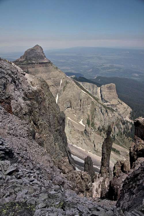 Reconnoiter Peak
Alternative route would be South Ridge. You access it from upper Weehawken Creek and head for the south ridge instead of east ridge. Head for the basin between Teakettle and Ridgway. You will have to get over a couple of false summits, and your elevation change will be little more, possibly 200 feet more when compared with East Ridge route.
You can also reach Ridgway's south ridge from Blaine Basin. I looked at this route from the summit, and it appeared like a scree hike.
Red Tape
There is no red tape. Parking, driving 4WD roads and hiking are free. Consider soaking in Ouray Hot Springs after a nice hike.When to Climb
Summer is the easiest with an easy approach. Winter provides some challenge with breathing the snow and avalanche danger. Always check for avalanche conditions prior venturing out in the winter.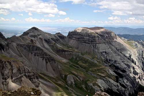 Mount Ridgway (left) and Whitehouse Mnt. (right) as seen from the summit of Potosi
 | 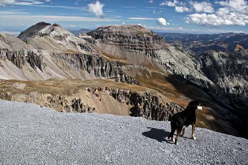 Mount Ridgway (right) and Whitehouse Mnt. (left) from the plateu below "Coffeepot"
 |
Camping
There are 2 campgrounds close by. Thistledown Campground is right across from the Weehawken Trailhead. Angel Creek Campground is 0.7 miles down the road. There are plenty of lodging opportunities in Ouray.External Links
- Mount Ridgway on 13ers.com
- Nice Information on Mount Ridgway
- Climb13ers.com - description of a route from Ridgway Hut (north side)
- Mount Ridgway on List of John