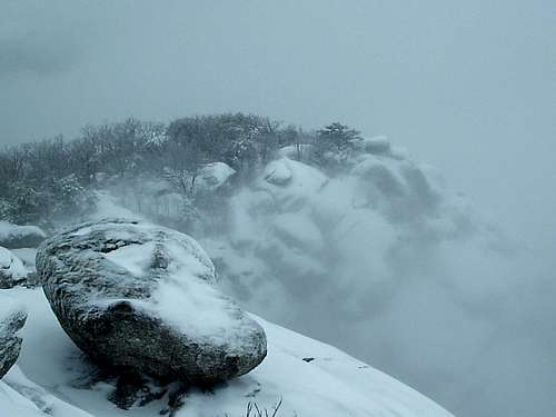
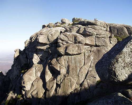
Many a Virginian has gotten his or her first real taste of mountaineering on Old Rag, a great mass of exposed granite east of the Blue Ridge crest in Virginia's Shenandoah National Park. Although nearby Skyline Drive has several hikes to craggy summits or outcrops, including the fine scramble on Bearfence Mountain, those hikes are principally short routes through the woods, with only a few hundred feet of elevation gain at the most, to reach the open rocks at the very end. Old Rag, though, requires almost 3 miles of one-way hiking to reach the summit by its shortest route, and elevation gain is anywhere from 2200-3000' depending on the specific route chosen. But even better is that much of the standard route to the summit is across open rock, giving about as close to an above-timberline feel as one is going to find in the Southeast. Factor in that parts of the standard route involve some Class 3 scrambling, and hiking Old Rag becomes an adventure, especially to novice hikers and to people unversed with the wonders of truly alpine mountains. In fact, one's first hike of Old Rag might inspire a mountaineering lust that may consume great sums of money, time, and family members' patience-- you have been warned.
Although it is not very high, not even among the ten highest peaks in Shenandoah National Park, where the highest summit is only 4011', Old Rag Mountain is nevertheless arguably the most impressive mountain in Virginia and in all the Southeast, vying for that honor with North Carolina notables such as Devils Courthouse, Grandfather Mountain, and Looking Glass Rock. All the exposed rock makes it stand out, and its position east of the main Blue Ridge, rising straight from the flatlands on all but its western side, makes it seem higher than it really is. From almost any point from which it is visible, Old Rag dominates the scene.
Old Rag's assets are also its liabilities, as it is a heavily used mountain. Supposedly, over 100,000 people visit the peak each year. Old Rag's proximity to a major metropolitan area (about a 2-hour drive from Washington, D.C) contributes to the crowds that frequent the mountain, but any exceptional mountain accessible by paved roads and day hikes is bound to attract attention no matter where it is. The mountain gets more popular each year, and some long-time SNP lovers now avoid the mountain or only visit it at "slow" times such as winter weekdays. But do not let this deter you from going if you have never hiked the mountain before; just start nice and early, and go on a weekday if you can.
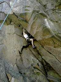
Old Rag also has excellent, very uncrowded technical climbing. Please see Section 4 for information on the climbing areas and options.
Routes Overview
There are three principal routes by which people summit Old Rag.
Ridge Trail/Saddle Trail
For hikers, this is the best way to go; it is also the most popular way. It is an 8.7-mile loop, and it involves about 2300' of elevation gain by the time it's over. Ascending via the Ridge Trail is recommended because the scrambling involved on that route is easier and more enjoyable done uphill. Highlights of the trail include a "cave" one must pass through, a natural staircase formed by columnar jointing of basalt, and some Class 3 scrambling sections. Please see the attached route page for more details.
From Berry Hollow
This is the favored route for those heading for the climbing crags on the mountain, as the trailhead is higher and the approach is shorter than from Weakley Hollow. The distance to the summit is 2.8 miles (one way), with about 1800' of elevation gain.
From Skyline Drive
A few tough souls brave this route, which is around 15 miles RT and involves significantly more total elevation gain than either of the other two routes does. Follow the Old Rag Fire Road as it descends into Berry Hollow, losing about 1400' of elevation, and then take the Saddle Trail to the summit, picking up nearly 1400' en route. Then descend to Weakley Hollow and start heading back via the Weakley Hollow Fire Road (see the attached route page for more details). This hike can be shortened, and the total elevation gain lessened, by returning from the summit via the approach route.
Probably unbeknownst to most hikers on Old Rag (it was almost 13 years after my first hike of Old Rag that I learned this myself), the mountain has over 100 established routes, some up to 100' in length, scattered about at various crags. Most are trad or toprope climbs, but there are many sport routes, too. The majority of the routes are 5.7 or harder, and many are dangerous slab routes and/or have minimal or no protection, but there are also a handful in the 5.4-5.6 range, and there are a very few under that range; such routes will appeal to adventurous scramblers and boulderers.
This section will introduce just three of the crags, chosen for their proximity to the main trails, year-round ease of access (several of the Old Rag crags are anywhere from hard to nightmarish to approach late spring through early fall due to undergrowth), and abundance of routes: Sunset Walls, the Summit Area Crags, and Skyline Wall. Highly recommended by my guidebook, though not detailed here (there are attached mountain pages for these and other crags), are God's Area and Reflector Oven, crags that are hard to reach during the hotter months (due to brush-choked access trails) and can also be hard to locate but which offer some outstanding climbs.
Sunset Walls
The Sunset Walls crags are located about 0.7 miles from the summit along the Saddle Trail. The spur trail to the cliffs is about 2.1 miles from the Berry Hollow Trailhead, and it makes almost no sense to approach this crag from any other trailhead unless you are planning to climb at more than one spot during your trip.
There are trad and sport routes here up to 50' in length, and they range from 5.5 to 5.12, with almost all the routes going at 5.8 or harder. There are three cliff tiers at Sunset Walls-- Lower, Middle, and Upper. The spur trail leads to Lower Sunset Wall (LSW); Middle Sunset Wall (MSW) is accessible via Class 4 scrambling from LSW, and Upper Sunset Wall (USW) is accessible via Class 4 scrambling from MSW.
Sunshine Buttress/Upper Sunset Wall
To Find Sunset Walls: About 2 miles from Berry Hollow (about 0.7 miles from the summit if approaching via the Ridge Trail), the Saddle Trail reaches a series of rock steps where the trail makes a prominent bend to the right. Look for a slab on the left and then find the beginning of a cairned route just beyond it. For more details, please see the attached Sunset Walls page.
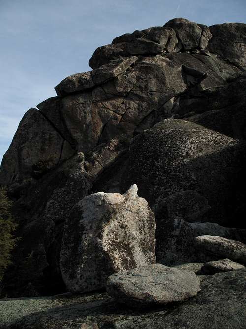
Summit Area Crags
These crags are easy to locate and offer at least five routes up to 100' in length and from 5.4-5.9 in difficulty. They face west, making them nice on spring and fall afternoons and even some winter afternoons, too. Bear in mind that temperatures up here can be a good 10 degrees F cooler than they are at the trailhead and that it can be very windy. Dress accordingly. The summit area is also a great bouldering location.
Summit Crags-- by Buz Groshong
To Find the Summit Area Crags: Where the Ridge and Saddle Trails meet atop the mountain, a marked spur leads to the summit blocks. Take the spur and bear left toward an open area with a few large boulders to its right. Hike a passageway through two of these boulders (the one on the right has an obvious diagonal crack across its face) and then look for a short chimney. Scramble down it and then look for a faint trail that leads down and right to the base of the cliffs.
Skyline Wall
Also called PATC Wall, this cliff is right off the Ridge Trail (in fact, the Ridge Trail passes across its top) north of the summit. The crag features several nice crack climbs in the moderate range. In all, it has at least 20 established routes ranging from 5.5 to 5.12, and the routes are from 50-95' in length. Because of the proximity of the Ridge Trail, it is easy to toprope routes here, but before doing that, consider whether you want to set up gear where hundreds of hikers may be passing right by.
These walls face north and are good for warm-weather climbing. They get little sunlight in winter since the sun rises and sets in the Southeast and Southwest, respectively.
Skyline Wall
To Find Skyline Wall: From the summit of Old Rag, the western and eastern ends of the Skyline Wall clifftop are about 5 and 10 minutes away. The western access is by a prominent boulder perched atop some slabs at the edge of the cliff. There is a chimney below this boulder, and it leads a short distance to a trail that accesses the base of the cliffs. The eastern access is across from a very prominent egg-shaped boulder that from certain angles looks like a balanced rock. Follow a break in the cliffs down to the base of the crag. These descents are easy to find and follow, but use caution; they involve Class 3 and 4 scrambling.
More Information
An excellent resource for technical climbing on Old Rag is Eric Horst’s Rock Climbing Virginia, West Virginia, and Maryland. The book has descriptions, diagrams, photographs, and directions to help you find and enjoy the crags.
Note to people using the guidebook: The book mentions an "Attention Hiking Leaders" sign near the summit and uses that sign as part of directions to some of the crags. This sign does not exist. There is, however, a sign indicating the spur trail to the summit and the directions of the Ridge and Saddle Trails. Use this sign as a locator instead of the sign the book indicates.
Getting There
1: To reach the most popular TH and the one recommended for hikers, follow these instructions.
At Sperryville, located along U.S. 211/522 east of Shenandoah National Park and in the park's shadow, turn south onto US 522 where it splits from 211 and turn right onto Virginia 231 shortly afterwards. There is good signage for these intersections. You can also reach 231 via 522 from Culpeper, and you can take 231 all the way from Charlottesville.
A little over 8 miles from Sperryville, watch for the signed turn to Old Rag at Route 602. The road becomes Route 707 at an intersection (stay left on the south side of the river). At the next fork bear left again, now on Route 600. Follow this road to its end at the parking area, which accommodates 200 cars. Park here and walk 0.8 mi to the upper parking area at the end of SR 600. If you arrive early enough or the night before, you may find a space at upper parking area (room for 8 cars, though I have seen twice that many there), which will save you 1.6 miles of hiking. The upper lot is sometimes closed on weekends.
Update: As of August 2010, the upper lot is closed and parking along the road to it is illegal. This is a permanent closure.
2: People interested in the destination more than the journey or in quicker access to good climbing crags can start at Berry Hollow.
At Sperryville along U.S. 211, look for signs indicating 522 and 231 and follow the directions to them. Turn right on 231. You can also reach 231 via 522 from Culpeper, and you can take 231 all the way from Charlottesville. After about 10 miles along 231, you reach a tiny town called Etlan. Look on the east side of the road for a small convenience store. Directly across the road from the store is SR 643. There should be a sign indicating access to Whiteoak Canyon. Follow this road for about 4 miles until you reach a stop sign. Turn right (a sign for Whiteoak Canyon should confirm this). You are now on SR 600, and it takes you all the way to the signed parking area and trailhead, almost at the very end of the road. Instead of turning into the parking area, continue straight for about 0.8 mi to the end of the road, which is where the Berry Hollow Fire Road begins. It is about 5 miles from the junction of 643 and 600 to the trailhead, and the drive takes about 15-20 minutes.
3: To hike from Skyline Drive, park at the Limberlost Trailhead (MP 43) and pick up the Old Rag Fire Road.
Red Tape
There is a fee of $10 per person 16 years of age or older, with an option of $25 per vehicle (good for a larger group). The pass is valid for one week from the date of purchase. On many weekends, rangers are present to collect the fees. Most of the rest of the time, an honor system exists. An Annual or America the Beautiful Pass covers up to 4 people.
No pets allowed. Remember that as much as you love your dog, it is still considered a pet. People routinely violate this restriction; please don't join them. People hiking from Skyline Drive have to pay an entrance fee of $15, but that fee is per vehicle. T
o reduce poaching, Skyline Drive is subject to nighttime closures during hunting season (mid-November through early January). Specific information about the dates, times, and sections for the current year is available on the park's website.
The park is open all year, but Skyline Drive does sometimes close after snow or ice storms. The park site does not give current road conditions, so call ahead (540-999-3500).
Camping and Lodging
Backcountry camping is permitted below 2800 feet (permit required-- this is free and can be obtained at the trailhead, at an entrance station on Skyline Drive, at Park Headquarters, or at a visitor center). Good campsites are scarce, though. The shelters along the trail are for day use only.
There is no developed camping at either trailhead outside the park. You can sleep in your car, though. The nearest campground on Skyline Drive is at Big Meadows, which is typically open early April through Thanksgiving Weekend and is about 10 miles south of Old Rag Fire Road. Half the sites can be reserved.
Lodging is also available at Big Meadows and Skyland (Skyland is about a 5-minute drive from Old Rag Fire Road) and is available from early spring through Thanksgiving Weekend.
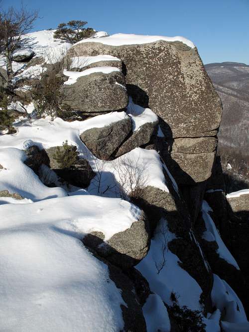
Old Rag is climbed in all seasons, but it's far less crowded in the winter. Take this mountain seriously in winter or after a snowfall; the Ridge Trail becomes icy and dangerous at such times. Crampons won't be necessary except perhaps following severe storms, but the cold-weather conditions will still warrant extreme caution, as it would be very easy to get badly hurt or even killed here at such times.
Other Links
Shenandoah National Park Telephone: (540) 999-3500
The per-person fee to enter Shenandoah National Park is now $10 year-round (as of 5/2018). There's also the option of paying a $25 per-vehicle fee, so if you plan to visit in a large group, consider carpooling.
Children refers to the set of objects that logically fall under a given object. For example, the
Aconcagua mountain page is a child of the 'Aconcagua Group' and the 'Seven Summits.' The
Aconcagua mountain itself has many routes, photos, and trip reports as children.
Parents refers to a larger category under which an object falls. For example, theAconcagua mountain page has the 'Aconcagua Group' and the 'Seven Summits' asparents and is a parent itself to many routes, photos, and Trip Reports.

 158461 Hits
 97.89% Score
 74 Votes


 The Staircase
 by hikeman76
 by velodurt
 by hikeman76
 by ShanrickV
 By Brad Snider
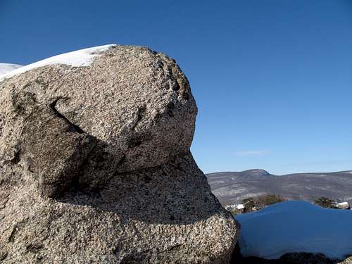


larvitar - May 29, 2018 6:10 pm - Hasn't voted
Per-Person Fee IncreaseThe per-person fee to enter Shenandoah National Park is now $10 year-round (as of 5/2018). There's also the option of paying a $25 per-vehicle fee, so if you plan to visit in a large group, consider carpooling.
Bob Sihler - Jul 7, 2018 1:51 pm - Hasn't voted
Re: Per-Person Fee IncreaseThank you for this update.