
|
|
Mountain/Rock |
|---|---|
|
|
43.07000°N / 19.02000°E |
|
|
7860 ft / 2396 m |
|
|
Overview
 Winter scenery of Lucin Vrh (2396 m)
When you enter in impressive Valoviti Do valley, few peaks will took your attention. For sure, one of them is Lučin Vrh (2396 m), 8th highest peak of DURMITOR massif.
Lučin Vrh (Luchin Vrh) is the nearest neighbour of Bobotov Kuk (2523 m) on the east side. Also, summit of Lučin Vrh is for sure one of the best viewpoints of Bobotov Kuk peak. Together with Bobotov Kuk, Lučin Vrh dominate above beautiful Valoviti Do (2027 m) rocky valley. From Bobotov Kuk, Lucin Vrh is separate by maybe the most impressive pass in Durmitor called Velika Previja (2351 m).
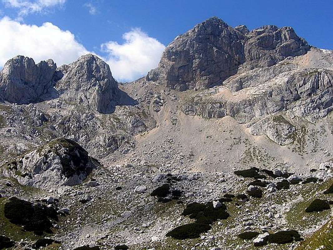
Lučin Vrh (2396 m) & Bobotov Kuk (2523 m) from Valoviti Do (2027 m)
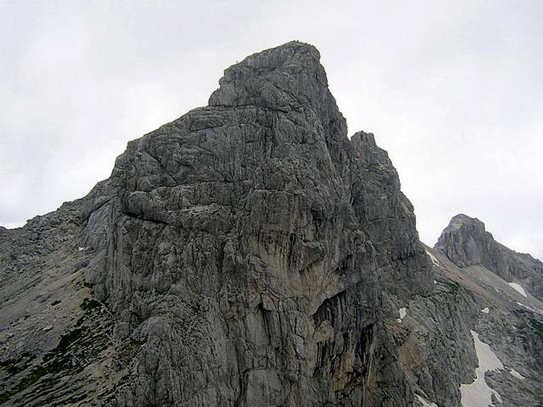
So, Lučin Vrh (2396 m) enjoy in privilege to stay between Bobotov Kuk (2523 m) on it's western side and Minin Bogaz (2387 m) on it's north-eastern side. If you will climb Lučin Vrh from it's northern side, you will enjoy in one of the best mountain scenery in Durmitor, Valoviti Do valley. But also, panorama of Lučin Vrh and it's surrounding peaks, looking from Surutka Valley or from amazing Trojni Prevoj (2245 m) pass, is also breathtaking. Both places are on the path of southern approach to Lučin Vrh - from Sedlo (1907 m) pass, via Uvita Greda (2199 m).
On another side, Lučin Vrh together with Ðevojka (2440 m) and Bobotov Kuk (2523 m) staying above Zeleni Vir (Green Vortex, 2028 m) lake, glacial lake with highest altitude in Durmitor National Park. You will enjoy in that scenery if you will use southern approach to reach the summit of Lučin Vrh. Both sides of Lučin Vrh are very nice and attractive.
LOCATION:
Lučin Vrh (2396 m) peak is placed in area of highest peaks of Durmitor massif, between two attractive and sharp peaks, Bobotov Kuk (2523 m) and Minin Bogaz (2387 m).
Lučin Vrh is situated on SW from Minin Bogaz (2387 m), Medjed (2287 m), Terzin Bogaz (2303 m) and Savin Kuk (2313 m), on S from Obla Glava (2303 m), on E from Bobotov Kuk (2523 m), Bezimeni Vrh (2487 m), Planinica (2330 m) and Susica Cannyon, on N from Štit/Šareni Pasovi (Colorful Layers, 2248 m) and Samar Pass (2075 m), on W from Sljeme (2455 m), Milošev Tok (2426 m), Bandijerna (2409 m) and Zupci (2309 m), on NE from Prutas (2393 m).
Eastern side of Lučin Vrh stay above Zeleni Vir (Green Vortex, 2028 m) glacial lake, while it's northern face dominate above impressive Valoviti Do (2027 m) rocky valley.
SUMMIT VIEW:
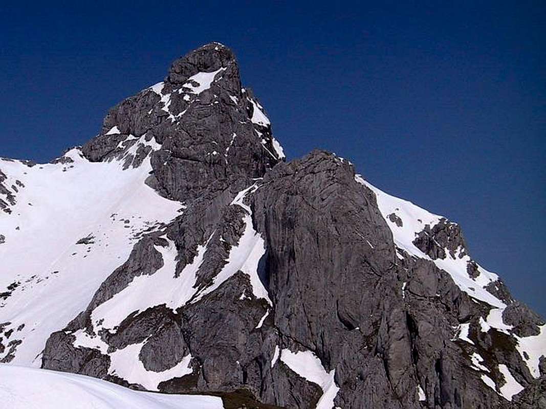
W view of Lucin Vrh (2396 m) looks to Bobotov Kuk (2523 m) and Bezimeni Vrh (2487 m).
Bobotov Kuk (2523 m) & Bezimeni Vrh (2487 m) from Lucin Vrh (2396 m)
E view looks to Sljeme (2455 m), Milosev Tok (2426 m), Bandijerna (2409 m), Minin Bogaz (2387 m), Zupci (2309 m), Medjed (2287 m) and to Mt Sinjajevina (2203 m).
N view looks to Obla Glava (2303 m), Crvena Greda (2175 m) and Cvorov Bogaz (2152 m), Valoviti Do (2027 m) valley, Crno Jezero (Black Lake, 1416 m), Jezerska Povrs (Plateau of Lakes) and to branch of Tara River Cannyon.
S view looks to Djevojka (2440 m) and Moraca Mountains (Kapa Moracka, 2226 m).
W view looks to Bobotov Kuk and Bezimeni Vrh, while NE view looks to Minin Bogaz and other peaks of central massif of Durmitor. This two views are most beautiful.
 |  |  |  |  |
Routes Overview
LUCIN VRH (2396 m):1. Southern approach I - (Sedlo pass - 1907 m): Sedlo pass (1907 m) - Uvito Zdrijelo (2140 m) - Surutka (2082 m) - Zeleni Vir lake (Green Vortex lake, 2028 m) - Velika Previja pass (2351 m) - Lucin Vrh (2396 m). Time: 2.45 h to summit and 2h for descend to Sedlo pass.
2. Southern approach II - (Sedlo pass - 1907 m): Sedlo pass (1907 m) - Uvito Zdrijelo (2140 m) - Trojni Prevoj (Tripple Pass, 2245 m) - Zeleni Vir lake (Green Vortex lake, 2028 m) - Velika Previja pass (2351 m) - Lucin Vrh (2396 m). Time: 2.45 h to summit and 2 h for descend to Sedlo pass.
3. Northern approach I: Crno Jezero (Black Lake, 1416 m) - Jaksica Mlin (1425 m) - Indjini Dolovi (1750 m) - Lokvice valley (Stari Katun, 1880 m) - Korita (1900 m) - Ledena Pecina (Ice Cave, 2160 m) - Valoviti Do (2150 m) - Velika Previja pass ( 2351 m) - Lucin Vrh (2396 m). Time: 5.30 h to the summit and 4.30 h for descend to Zabljak. One day trip (10 h).
4. Northern approach II: Crno Jezero (1416 m) - Jaksica Mlin (1425 m) - Korita - Ledena Pecina (Ice Cave) - Biljegov Do - Valoviti Do (2027 m) - Velika Previja pass (2351 m) - Lucin Vrh (2396 m). Time: 5.30 h to summit and 4.30h for descend to Zabljak. One day trip (10 h).
5. Skrka Valley approach: Skrka Mountain Hut (1723 m) - Samar Pass (2075 m) - Zeleni Vir Lake (Green Vortex, 2028 m) - Velika Previja Pass (2351 m) - Lucin Vrh (2396 m). Time:2.5h - 3h.
 |  |  |  |  |
Getting There
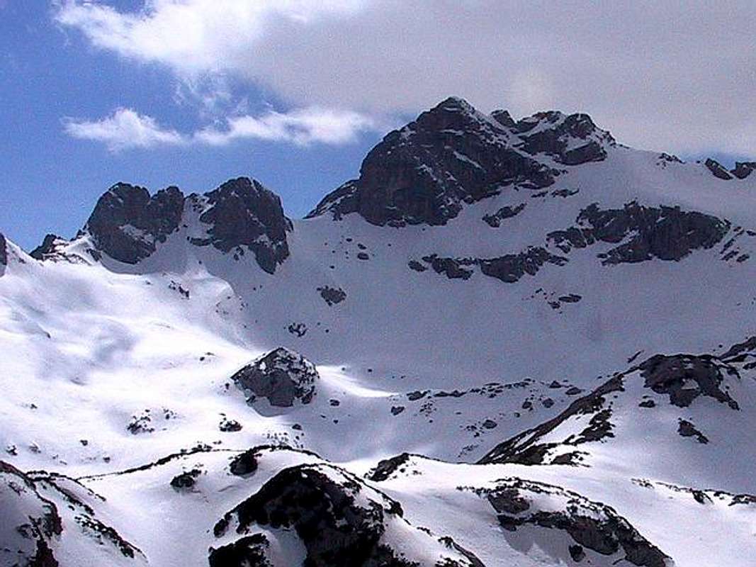
Winter scenery of Lucin Vrh (2396 m) and Bobotov Kuk (2523 m)
Gateway to Durmitor National Park and Lucin Vrh (2396 m) peak is Zabljak (1456 m) town. Information how to get there:
By Plane
~To Beograd (Belgrade, Serbia&Montenegro capital) airport. Than with plane to Podgorica, capital of Montenegro, or with bus or car to Zabljak town.
~To Podgorica airport. Than with bus or car to Zabljak town.
Information about flights find on the sites of JAT Airways, a former Yugoslav airlines, or on Montenegro Airlines.
By Bus
~Beograd (Belgrade)-Zabljak
~Podgorica-Zabljak
~Niksic-Zabljak
~Pljevlja-Zabljak
Buses go to Zabljak from Beograd (Belgrade) twice a day and from Podgorica, Niksic, Pljevlja and Mojkovac several times per day.
By Car
~Beograd (Belgrade)-Zlatibor-Nova Varos-Prijepolje-Pljevlja-Zabljak
~Niksic - Savnik (47km) - Zabljak (37km): 84km; Niksic to Zabljak approach from south.
~Niksic - Savnik (35km) - Zabljak (37km): 72km;
~Podgorica - Niksic (55 km)-Savnik (47 km)-Zabljak (37 km): 139 km; Add this length if you are going to Zabljak from Podgorica via Niksic. Road to Niksic from Podgorica is good.
~Podgorica - Kolasin (71km) - Mojkovac (21km) - Zabljak (67km): 159km; road is good all the way to Zabljak. Behind Podgorica (56m) you go inside Moraca River canyon (one of spectacular Montenegrin canyons). It is up to 1000m deep and has wild sides. That's spectacular drive. After that, from "Djurdjevica Tara" bridge to Zabljak - 23 km.
 |  |  |  |  |
When To Climb
Lucin Vrh (2396 m) and Bobotov Kuk (2523 m, behind) from Trojni Prevoj (Tripple Pass, 2245 m)
Lucin Vrh (2396 m) and other peaks in Durmitor's massif you can climb during all year seasons, but ideal period for climbing is mid June - mid September.
During the winter, Durmitor usually switches into ski resort. Under Savin Kuk peak (2313 m) is Durmitor Ski Center. (gondolas, ski lifts, chair lifts, restorants and their customers).
Crno Jezero (Black Lake, 1416 m) location is a common climbing starting point. All major trails further uphill are well marked with white circle/red border marks.
Whole Durmitor mountain is very good marked. Thanks to Branislav Cerovic, greatest knower and devoter of Durmitor National Park, who marked all routes on Durmitor mountain.
 |  |
Camping
Camping permitted on camping dedicated spots only.Optimal places where you can stay before climbing of Lucin Vrh (2396 m) are Skrka Hut (1723 m) in Skrka Lakes Valley and Lokvice Hut (1693 m) in Lokvice Valley. Skrka Hut you can when you practice Skrka approach, while Lokvice Hut is optimal for when you want to reach Lucin Vrh summit from it's northern side (northern approach).
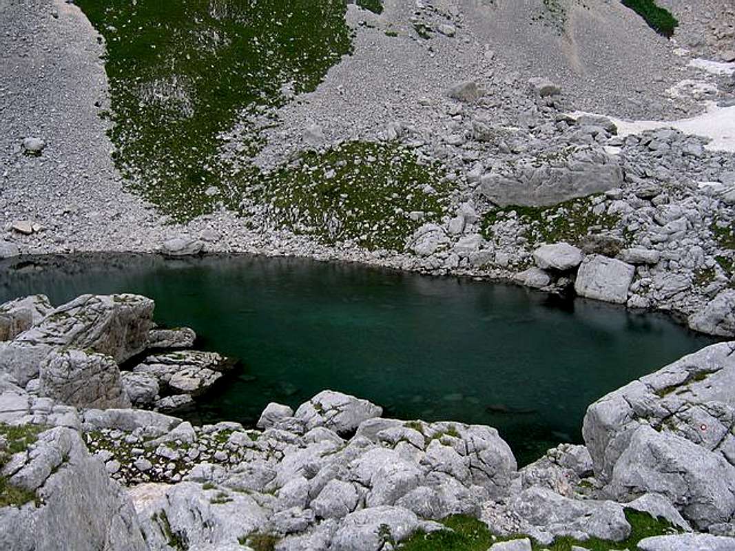
Zeleni Vir (Green Vortex, 2028 m) lake is placed belowe Lucin Vrh (2396 m)
Major huts are in good condition, but with no service. Still, open to the general public. Hikers/climbers are supposed to bring all the jummy stuff with them.
On Durmitor exist camp in Ivan Do and Razvrsje, and few mountain huts and bivouacs:
~Hut with few small shepherd's houses in Lokvice valley
~Hut in Skrka Lakes valley (you can sleep and buy the food)
~Bivouac in Velika Kalica valley
~Hut "Mushova koliba" on the road from Zabljak to Obla Glava (2303 m) peak, near Ledena Pechina (Ice Cave) - empty simply hut from wood, without service, simple conditions...
~In Ivan Do camp price for camping is 4 Euro per day.
Also, in Zabljak town you can rent private room or apartment. Price for 2-beds apartment with kitchen and bathroom: 10-12 Euro (5-6 Euro per person).
In some villages on mountain, for example in Bosaca village, you can rent a 2-beds apartment for price 6-8 Euro (3-4 Euro per person) with free milk products every day (1 liter of caw milk).
 |  |  |
Mountain Conditions
The best weather forecast on Internet for Durmitor (Zabljak town) is VREME YUBC NET site. You can see 5 days forecast for Durmitor area, 4-times-daily forecast. |  |  |
Maps
Exist three maps of Durmitor:1. Map of Durmitor Massif & Tara Canyon - 1:25000. Author: Branislav Cerovic. You can buy it in Zabljak town in almost every store. Price: 5-6 euro.
2. Map of Durmitor National Park & Tara Canyon - 1:25000. Author: Branislav Cerovic. You can buy it in Beograd (Belgrade, Serbia) in Geokarta Co, Belgrade. Price: 2 euro. This map is better than first one and include many informations and facts about routes, peaks, lakes, glacial cirques, valleys, canyons,...
3. Durmitor Mountain Guide & Map. Short mountain guide with some basic informations and facts. Author of map: Pavle S. Bandovic. Editor: "Summit" Travel Agency, Zabljak, 2005. Price of Guide&Map: 7 euro.
 |
Red Tape
No fees or extra fees for entering the National Park.No permits needed either.
Usual rules of behaviour for NPs do apply.
 |  |