
-
 43021 Hits
-
 95.98% Score
-
 57 Votes
|
|
Mountain/Rock |
|---|---|
|
|
45.82844°N / 6.86827°E |
|
|
Mountaineering |
|
|
Summer |
|
|
15577 ft / 4748 m |
|
|
Overview
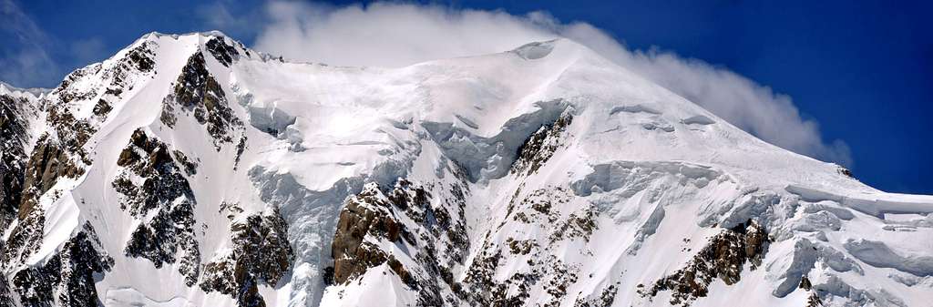
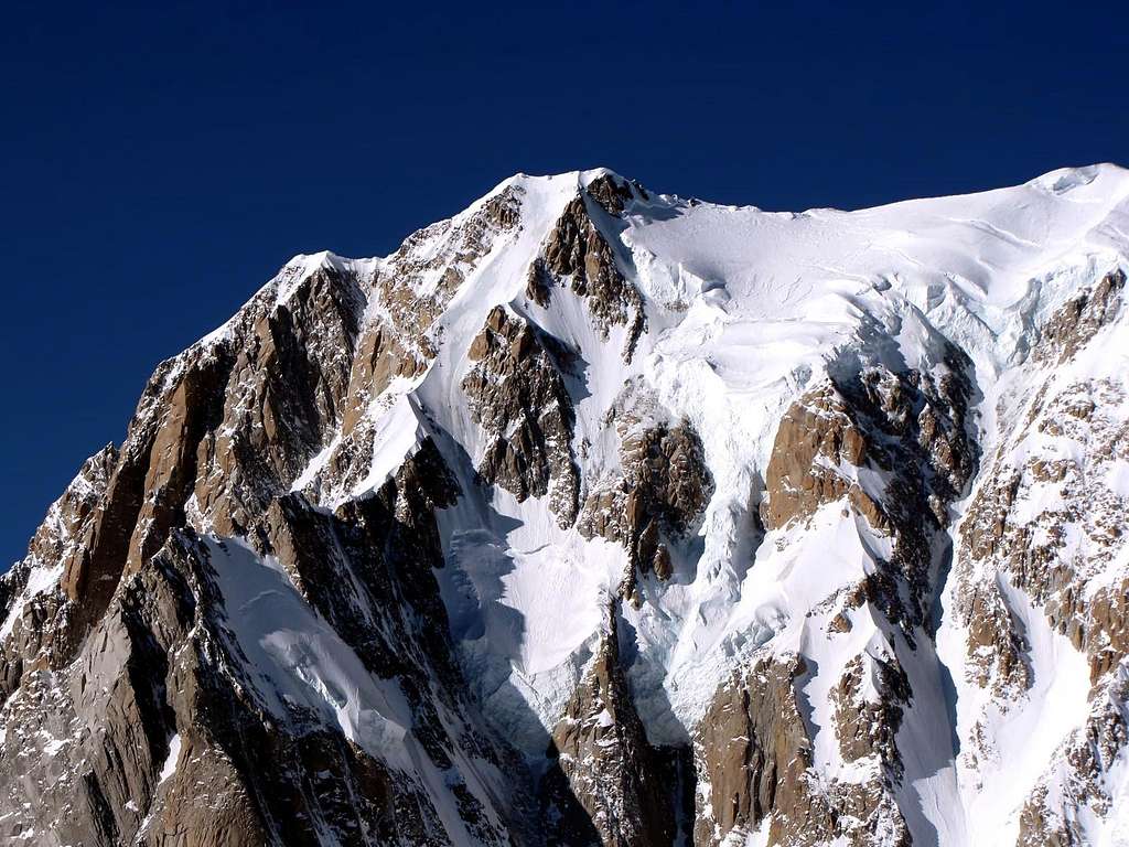
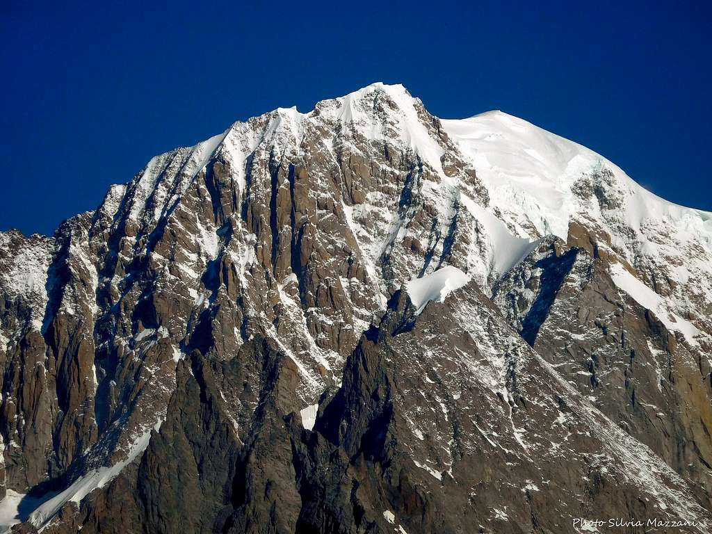
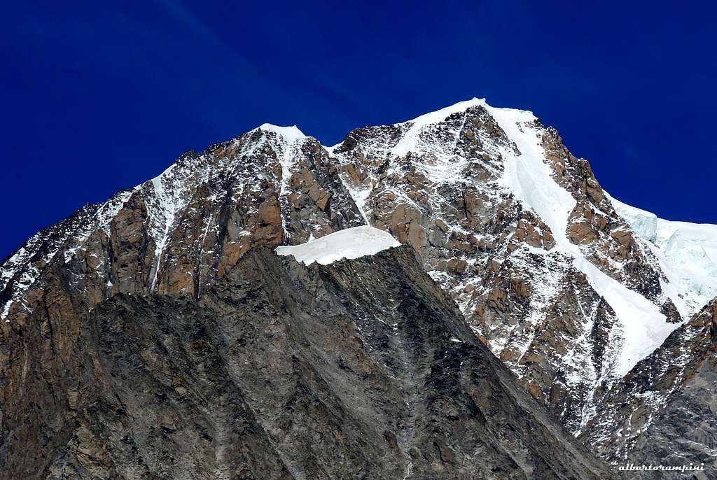
Monte Bianco di Courmayeur 4765 m
Monte Bianco di Courmayeur is the South-East shoulder of Mont Blanc with 4.765 m. It is offshore to the Mont Blanc about 800 m in the direction of Courmayeur. If you look to the Mont Blanc Massif from Courmayeur it seems that the Monte Bianco di Courmayeur is the top of Mont Blanc. Actually Monte Bianco di Courmayeur should be considered as the fore-summit of Mont Blanc, in fact its prominence compared to Mont Blanc is lower than thirty meters. However, due to its morphological, mountaineering and historical importance, it had been included in the main list of 4000 in the Alps. Check here the complete list of the 82 alpine Fourthousanders and the 46 minor summits: Club4000.
Monte Bianco di Courmayeur is separated from Mont Blanc by the Col Major 4720 m. A controversial question concerns the exact position of the border between Italy and France: does it run across Mont Blanc di Courmayeur or not? According to the latest information on the web, the border between Italy and France would run on the main summit of Mont Blanc and not on the Mont Blanc di Courmayeur; consequently this latter summit would be included entirely in the Italian territory. See here the latest information: The border on Mont Blanc.


|

|
History
The first known ascent was made on 18 August 1822 by F. Clissold with Joseph Marie Couttet and five other guides, who reached the summit descending from the main summit of Mont Blanc.
Getting There

The starting point to climb Monte Bianco di Courmayeur is the town of Courmayeur in the South side (Italy) of the massif.
Getting to Courmayeur
- From Aosta via the Autoroute A5/E25 (35 km)
- From Torino via the A5 motorway connecting Torino to the Mont Blanc Tunnel, passing through Ivrea, the Aosta Valley and Courmayeur (146 km)
- From Chamonix: 25 km through the Mont Blanc Tunnel in 30 minutes
Getting to the Val Veni
From Courmayeur take the Val Veny road on the left of the town and reach the locality Freney, where it starts the route to the Rifugio Monzino.
There are not easy routes to summit Monte Bianco di Courmayeur. The only easy access is from the main summit of Mont Blanc. So on this page it is shown a brief overview about the main routes to summit the Mont Blanc. There are 4 commonly used routes to Mont Blanc:
1 - Normal Route via the Aiguille du Goûter. From Chamonix - Les Houches - Bellevue - Nid d´Aigle - Refuge Tête Rousse - Refuge du Goûter - Bosses ridge
2 - The Grand Mulets route is a longer route to the summit. Chamonix- Plan de l´Aiguille - Refuge Grands Mulets - Glacier des Bossons
3 - 3 Mounts Traversee - Chamonix - Aiguille du Midi - Refuge Cosmiques - Mont Blanc traverse
4 - Italian Normal Route - Courmayeur - Val Veni - Rifugio Gonella - Glacier du Mont Blanc
From Switzerland you reach Chamonix 1.030 m by car or by train from Martigny (40 km), then Mont Blanc Tunnel to Courmayeur. Distances to Chamonix: Gèneve: 86 km Aosta: 59 km From Chamonix 8 km to Les Houches. There is a bus connection between Chamonix and Les Houches.
Routes overview
- Brouillard ridge AD+, rock difficulties up to III+, the rock is in some parts crumbly. Time: 10-18 hours from Rifugio Monzino, 2.200 height meters difference When you climb the ridge you make the peak of Pic Luigi Amedeo (4.469 m)
- Innominata ridge D+, one of the most famous ridges in the Mont Blanc area, combined climbing. Time: 12-17 hours from Rifugio Monzino, 7-10 hours from Bivacco Eccles, 1.450 height meters from Rifugio Monzino
- Peuterey ridge (with crossing Aiguille Blanche): D+, rock difficulties up to IV-, mostly III and II, combined climbing, ice up to 55°. Time: 10-20 hours from Rifugio Monzino, 2.500 height meters
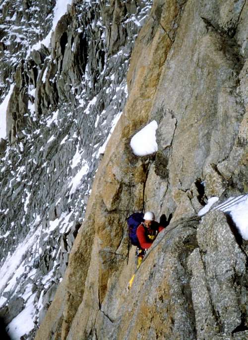
- Pilone Centrale del Freney
ED-, rock difficulties up to VI grade UIAA and A1
First ascent: Chris Bonington, Ian Clough, Jan Duglosz, Don Whillans, 27-29/08/1961
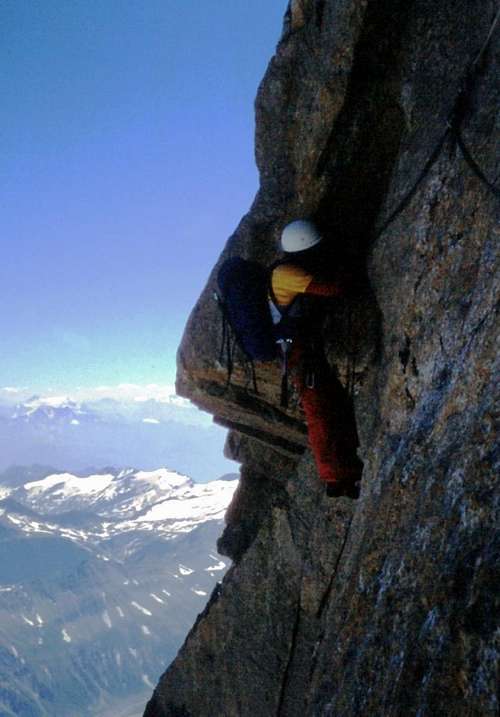
One of the most classic high alpine routes in the Alps that allows you to climb to the top of Mont Blanc along the rock pillar at the highest altitude of the whole group. The overall physical and mental commitment required to climb it makes it a legendary and timeless climb.
The starting point to climb is the Bivacco Lampugnani-Grassi. From the Val Veny climb to the Refuge Monzino 2561 m (2 hours) and then to the Bivouac 3850 m (further 5-6 hours). For the access see below the chapter "Huts and Bivouacs". From the bivouacs you cross to the left to the base of a snow and ice gully and climb up to Colle Eccles 4021 m where there is the first of the two anchors that allow the access to the upper Freney glacier (two 60-meter abseils plus a short downhill section). Once you reach the glacier cross it, staying at altitude under the bergschrund. You reach the lowest rocks of the pillar, more or less in the middle at about 4000 m altitude. The crossing of the upper Freney glacier must be carried out very early in the morning before the sun rises due to the risk of falling stones. From the bivouac to the base of the pillar it is necessary from 2 to 4 hours.
Route report
From the base of the pillar (some broken fixed ropes) you climb up a dihedral with overhangs. Passed the dihedral, climb a blade and a second dihedral to the right, reaching a terrace IV+. Again to the right climb a crack (V+) reaching some ledges. Continue at first slightly to the left and then to the right for three pitches. Some variations are possible both to the right and to the left. Slabs and grooves to the right for about 40 m (old ropes in place), V. Pass a difficult dihedral near the edge (V+) closed by an overhang (V+ and A0), then climb a chimney crack (IV+). After a snowy gully on the right, climb a line of craks (V-) for two pitches. To the right of a chimney often with ice, climb along grooves (V) and a dihedral often frozen (V+, VI-). Up a snowy slope and a slab sometimes icy get the base of the Chandelle. Good bivy place.
|
|
The Chandelle is about 120 meters of difference in height. Climb 15 m above a detached pillar (V+, A0). To the left, follow some cracks reaching some overhangs (20 m, V+, A1). Traverse to the right (pegs old rope) and from a small niche continue to traverse beyond the edge up to dihedral closed by a cracked roof (V+, A1, 20 m). Climb the dihedral for about 20 m and exit the roof to the left up to a terrace (A2 and V+). A wall cut by a crack (V, 10 m, jammed friend) leads to a narrow ledge, Cross it about 35 m to the left and continue slightly to the left of the pillar, climbing a dihedral and a slab (V-, 20 m). Climb another slab on the left (V+ 30 m). Head to the right on slabs (V) and then to the left on easier and broken rocks (IV) getting the tiny summit of the Central Pillar. From the summit abseil down to a notch (another uncomfortable place to bivy) and with three pitches on mixed ground reach the Brouillard ridge. Follow the Brouillard ridge and climbing a last steep snowy slope get the summit of Monte Bianco di Courmayeur 4765 m. From here take a snow ridge, pass the Tournette rocks and downclimb to the Col Major, from which a wide snow-slope leads to the main summit of Mont Blanc.
See here on SP another route report: Central Pillar of Freney route report on SP
Descent: as mentioned in the "Getting there" paragraph there are different Normal Routes to get the main summit of Mont Blanc. The recommended route for the descent is the Normal Route via the Aiguille du Goûter.
- The Monte Bianco di Courmayeu can also be summited from the main summit of Mont Blanc.
It's possible to reach the summit of Monte Bianco di Courmayeur crossing from the main summit of Mont Blanc, useful info for everyone interested to summit the Monte Bianco di Courmayeur without undertaking any of the demanding routes mentioned in the "Routes" chapter. The trip takes about 25 minutes, when the conditions are good. In the flank there is often blank ice, so you should take care. On the ridge there are huge cornices. Keep distance!
Huts and bivouacs

Rifugio Monzino 2590 m
Situation: Italian side of Mont Blanc Group - It stands among the glaciers of Brouillard and Freney Open: from June to September
Size: 55 persons
Winter-shelter: 12 persons
Guardian: Famiglia Chanoine
Hut's phone: +390165809553
Mobile: +393384839094 - +393339480629
Road approach: from Courmayeur take the Val Veny road. Continue for about 5 km to the locality Freney. Parking lot near the Bar Pramotton.
Walking approach: by walk to the Freney cottages. After crossing the two bridges, turn left onto path 16. Cross another bridge over the Freney stream. A little further on you will turn right and shortly to the start of the Via Ferrata, divided into three sections, and leading to the refuge (2-3 hours from the car-park).
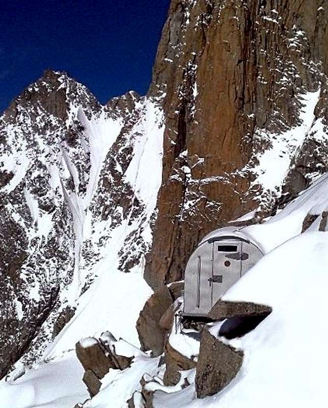
Bivacco Giuseppe Lampugnani - Giancarlo Grassi 3580 m Accommodates up to 9 people in a high barrel structure m. 2 m. at the highest point - always open Owner: CAAI Club Alpino Accademico Italiano The current bivouac stands on the South-west ridge of the Pic Eccles and replaces the original 1939 which was distrieved in 1952. The bivouac is co-named to Giuseppe Lampugnani from Novara, mountaineer and one of the founders of C.A.A.I. and companion of the Gugliermina brothers in many wrist enterprises on Monte Rosa and on Monte Bianco and Giancarlo Grassi member of CAAI and Alpine Guide, writer, mountaineer of international fame, pioneer in the research and implementation of new routes of high difficulty on rock and ice. See here more info about the bivouac: Club Alpino Accademico Italiano. See here on SP a profile of Giancarlo Grassi: Giancarlo Grassi, the Man of the Crystal Garden .
Approach - From the Rifugio Monzino on the Chatelet 2663 m the small glacier of the Chatelet can be climbed back to the right; we proceed for a short slope of smooth and wet slabs and for scraps towards the lower shoulder of the southern crest of the Innominata from which we descend obliquely to the left on a snowy slope to reach a shelf of the Brouillard glacier north of a rocky islet surrounded of seracs. You cross this shelf to the left in the direction of a rocky buttress of the summit ridge of the Innominata. Cross the bergschrund on the left and climb up obliquely on a large frozen slope, getting a tiny ice shelf that puts you at the lowest depression of the Col du Freney (about m.3600, h. 4). From here climb up the frozen slopes, then head to the right towards the upper edge of a rocky escarpment that rises diagonally above the precipices of the Freney. You get a craggy, short and very narrow gully, which leads to the terminal rocks of the Pic Eccles where it's located the bivouac (h. 3-7)
Refuge du Goûter 3817 m
Open: from May to October
Owner: FFME Fédération Française des Clubs Alpins et de Montagne
Guardian: Antoine Rattin
Phone: 04 50 54 40 93
Time: from the tram station 2-3 hours to the Refuge Tête Rousse, from there to Cabane de l´Aiguille du Goûter 2-3 hours
Red Tape
No fees no peermits required
When to climb
From July to September
Meteo
Meteo Valle d'Aosta
Chamonix Meteo
Guidebooks and maps
Guidebooks
“Monte Bianco Vol. I” di Gino Buscaini, Collana Guide dei Monti d’Italia CAI TCI, 1994
“Monte Bianco - Guide Vallot” ed. Mediterranee, 1999.
“Il massiccio del Monte Bianco – Le 100 più belle ascensioni” by Gaston Rébuffat, Zanichelli Edizioni,
“Rifugi e Bivacchi delle Alpi Occidentali” by Cesare Re, Ed. Guide Macchione, 2005
“Rifugi e Bivacchi del CAI” by Franco Bo, Ed. Priuli e Verlucca, 2002
Maps
CNS 1:50000, Courmayeur, foglio 292
Kompass 1:50000, Monte Bianco, foglio 85
De Agostini 1:50000, Monte Bianco