
|
|
Mountain/Rock |
|---|---|
|
|
45.91370°N / 7.02000°E |
|
|
Italy/France |
|
|
Mountaineering, Trad Climbing |
|
|
Summer |
|
|
12339 ft / 3761 m |
|
|
Overview
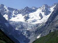 South side
Punta Isabella has two very distinct summits: the northern 3761m is a small rocky peak emerging from the icy plateau of Col de Triolet, the southern 3753m is the summit of a powerful spur sinking in the Glacier de Triolet. The two summits are connected by an airy ridge. The northern is the summit usually climbed.
Punta Isabella is named after Miss Mary Isabella Stratton who climbed it for the first time with Jean-Esteril and Pierre Charlet in 1875. After this, and many other more challenging climbs, like the first winter ascent of Mont Blanc, she finally got married with her guide Jean-Esteril.
Getting there
Access to the normal route, on the north side of the mountain, is via Chamonix and the Montenvers to Refuge du Couvercle .From Chamonix take the train to Montenvers-Mer de Glaces 1913m. From Montenvers station follow the trail south and descend to the Mer de Glace using several sections of ladders fixed on the cliffs (Echelles). Do not use the cableway to the Mer de Glace.
Once on the glacier pass the area with large crevasses, usually on your right. Move in the middle of the glacier and then aim left toward the central moraine. Go over the moraine (a big barrel high on the moraine mark the spot) and follow the cairns until you see a big white sign on the cliff on your left. The sign points to the ladders of the Egralets. Climb the ladders, the first section is vertical and about 25m high. Then follow the trail to the hut (2687m), 3.5 hours from Montenvers. None of the ladders on the cliffs to get in and out of the Mer de Glaces are equipped with safety cables, ferrata style.
 View from Refuge de Couvercle
Route overview
The normal route, even though not difficult, involves travelling on a crevassed glacier, climbing a fairly steep ridge and short sections of mixed terrain.The Glacier des Courtes is notorious for being problematic when not covered by aboundant snow, i.e. late in the season or in dry years. A large crevasse cuts through the glacier from side to side where the glacier narrows, just before the lower plateau, with deep moats at its end. If this crevasse is not bridged it will be difficult to gain the ridge. Call the hut keeper and ask for the actual condition of the glacier. With this caveat the trip to Punta Isabella a fine journey to a very panoramic hut followed by a moderate climb to a summit with a dramatic view on the jagged main ridge. It is ideal to test your skills on ice and mixed terrain.
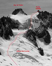 The route The route |  The route The route |
WNW Spur - Normal route - 1074m from Refuge de Couvercle, PD+
From the hut follow the trail passing under the old hut. Follow the cairns north-east and descend to the Glacier de Talefre on loose moraine debris (don't follow a first line of cairns to your right, they lead to a wet area and unsafe descent). Walk up the main branch of the glacier keeping the lower moraine of the Jardin de Talefre well to your left. Go up steeper slopes to the Glacier des Courtes and stay on the righ side of the glacier (your left). Pass the large crevasses to gain the lower plateau under the serac wall. Turn south (right), without entering the plateau, and gain the snow ridge by an easy ramp. Climb the first ridge, a short section of mixed, and a second steeper ridge 40o. Reach the upper Plateau de Triolet, traverse the bergschrund and climb the north face directly to the summit in one pitch of mixed (II UIAA belay/rappel ring in place). 4h30min from the hut.
Return by the same route.
 The ridges from below The ridges from below | 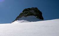 The summit The summit |  The ridge from above The ridge from above |
 Summit view