"Rattlesnake Mountain"

Page Type Page Type: Mountain/Rock
Location Lat/Lon: 36.58476°N / 118.12449°W
Additional Information County: Inyo
Activities Activities: Hiking
Seasons Season: Spring, Summer, Fall, Winter
Additional Information Elevation: 5369 ft / 1636 m
Sign the Climber's Log

Overview

White Mtn. Peak from Rattlesnake Mtn.White Mtn. Peak from Rattlesnake Mtn.
A dome shaped hill locally known as Rattlesnake Mountain (unnamed on topo) is a prominent sight in the Alabama Hills west of Lone Pine below the mighty eastern scarp of the high Sierra. This easily accessed roadside scramble makes for a fun little hike that can be done in a hour or so. The top is roughly an acre peppered with the typically interesting rock formations that characterize most of the area. This arid, rocky elevated plain offers fine views of the Lone Pine Sierra from Wonoga Peak south to include Mt. Langley, Lone Pine Peak, Mt. Whitney and all the way to Mt. Williamson and beyond to the north. The White and Inyo Mountains rise to the east and Owens Lake lies beyond to the south.

Getting There

Looking east down to Lone PineDown to Lone Pine from Rattlesnake Mtn.
From Hwy. 395 in Lone Pine take the Whitney Portal Road 3 miles west to the Horseshoe Meadows Road going south. Turn right and go about a half mile. Rattlesnake Mtn. looms to the right. Park off to the side of the road and walk a few hundred yards toward the east slope of Rattlesnake Mountain. Scramble up though the wide class 1-2 northeast chute to the top. This is approximately 1 mile round trip with 800' gain.

Red Tape

Inyo Mountains from Rattlesnake Mtn. 
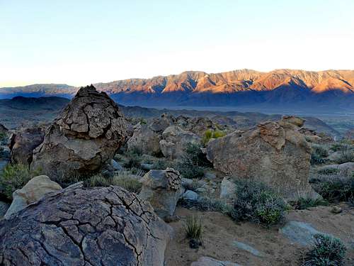
Inyo Mtns. from Rattlesnake Mtn.
This is Alabama Hills National Recreation area and there are no posted resrictions.

Camping

Rattlesnake Mtn. south viewRattlesnake Mtn. south view
Lone Pine Campground: 5,800' el. From Hwy. 395 in Lone Pine take the Whitney Portal Road 6.7 miles west. Turn left and go follow the side road a half mile staying to the right as it drops down to the campground next to Lone Pine Creek.

Tuttle Creek Campground: 4,900' el. From Hwy. 395 in Lone Pine take the Whitney Portal Road 3 miles west to the Horseshoe Meadows Road. Go south 1.6 miles. Take the paved road to the right. The first campgound is at 1 mile. The second campground is across the Tuttle Creek bridge another half mile in.

There are also plenty of 2 track pullouts throughout the area for car camping without facilities.

Lone Pine weather forecast

Lone Pine High Sierra from Rattlesnake Mtn.Lone Pine Sierra pano from Rattlesnake Mtn.
For current weather and 5 day forcast click here.