
-
 6482 Hits
-
 83.69% Score
-
 17 Votes
|
|
Mountain/Rock |
|---|---|
|
|
36.60541°N / 118.12764°W |
|
|
Inyo |
|
|
Trad Climbing, Sport Climbing |
|
|
Spring, Summer, Fall, Winter |
|
|
4667 ft / 1423 m |
|
|
Overview
 The two original routes on this formation
 Mount Whitney viewed from Alabama Hills
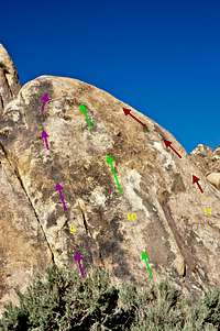 routes of the extreme right
 Left side
Looking across the wash from Cattle Pocket area you see a series of narrow and parallel rock formations. The empty ally ways in between these formations are reminiscent of the narrow passageways of the Middle East and the old Roman streets. They are flanked by tall walls on both sides and you feel like your shoulders could rub against the sides. This entire area is aptly known as The Corridors.
These corridors are no more than a few feet wide. The side walls are steep and, in some cases, overhanging. Inside of these corridors have never seen the sunlight and they seem to generate their own air current making them an ideal place to escape from the heat of the summer months. This lack of direct sunlight has resulted in less temperature fluctuations between day and night time which in turn has resulted in much better rock quality.
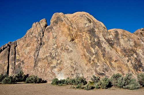
In contrast to the corridors themselves, the East End, the subject of this page, has a different meteorological history. The east end of The Corridors is a low angle rock exposed to the morning sun. The temperature fluctuations are much greater and the rock quality is not as good as the inside of the Corridors. The less than vertical pitch of the rock has made climbing on the East End much easier than the steep side walls of the inside of the Corridors. Arguably, the moderate nature of the rock here has resulted in a face that, in my humble opinion, has been overdeveloped.
The history of route development in the Corridors area dates back to the late 1980s, may be even earlier. The first time I noticed the signs of climbing on this formation was in the early 2000s when there were only three established routes; Trevor's Crack, El Chato and Glass Bead Game. I didn't know the names of these routes until a few years later when the first guide book to the area came out. When I returned to this formation in 2009, I was surprised to see nearly a dozen side by side bolted routes on it.
I can see the attraction for this formation. Approach time is zero as you can drive your car to touch your bumper to the rock itself. There is a huge parking area. The base is perfectly flat and the rock is in the sun for better part of the day making it a great place to climb during the cold seasons. Finally, there are a good number of easy to moderate routes for a big party with different ability levels.
How to Get to the East End of The Corridors:
From the town of Lone Pine, California, on Highway 395 take Whitney Portal Road at the only traffic light in town. Drive 2.7 miles west on this road to intersect Move Road. Turn right onto the Movie Road. This road is paved for a short distance then it turns into a dirt road. The first dirt road to intersect the Movie Road heads for Shark's Fin. Miss this one and drive about half a mile to the next dirt road from the left. Turn into this one and pass by Paul's Paradise. Shortly further up the road you will see the Blackhawk Pinnacle and the beginning of Cattle Pocket. Before reaching the Blackhawk Pinnacle look for a dirt road to your right. Take this road that should head north for a short distance then west, left again. Note; taking this side road avoids having to cross the wash that is deeper a bit further. Stay on this road all the way to the East End of The Corridors.
List of the routes
The Corridors, East End | |
| 1 | Under Mexicali Stars, 5.7, bolts, anchor |
| 2 | Senior Daredevil, 5.9, bolts, anchor |
| 3 | Trevor's Crack, 5.9, Standard rack, pro to 4 inches |
| 4 | El Chato, 10b,,bolts, anchor |
| 5 | Lynch Mob, 10c, bolts, anchor |
| 6 | Glass Bead Game, 10d, bolts, anchor |
| 7 | Mysterious Desperado, 10b, bolts, anchor |
| 8 | Lawless Riders, 5.8, standard rack, pro to 4 inches |
| 9 | Rider of The Dawn, 10a, bolts, anchor |
| 10 | Rider of The Deadline, 5.9, bolts, anchor |
| 11 | Rider of The Law, 5.9, bolts, anchor, not shown in the photo |
Routes topo
 |  Routes Topo Routes Topo |  |
Camping
 Cattle Pocket on the left and The Corridors, East End on the right
If you don't mind driving another fifty miles, there are many campgrounds along Bishop Creek just to the west of Bishop. There are also many places in The Buttermilks area that are close to a creek that are suitable for camping. Please do not camp in The Buttermilks bouldering area. That area is very crowded and is suffering from the impact unregulated camping has caused.
The following links should help finding a good campsite
Horton Creek Campground
Rock Creek Canyon
Inyo National Forest
Bishop Creek and vicinity camping
External Links
The Alabama HillsMount Whitney
Sierra Nevada Range