
-
 6146 Hits
-
 85.87% Score
-
 21 Votes
|
|
Mountain/Rock |
|---|---|
|
|
36.60689°N / 118.1319°W |
|
|
Inyo |
|
|
Spring, Summer, Fall, Winter |
|
|
4300 ft / 1311 m |
|
|
Overview
 Walnut Tower
 Pistachio Tower
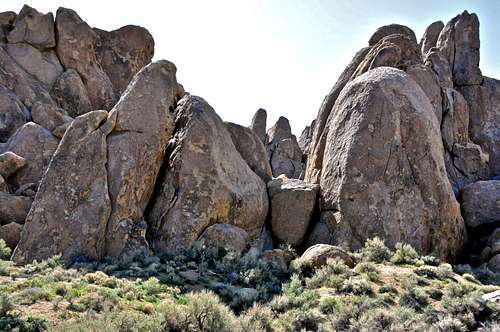
Nut Towers is the name for a collection of rock formations located to the southeast of The Western Wall and across the wash from Tall Wall of the Alabama Hills on the outskirts of Mount Whitney in the Sierra Nevada Range, California.
In rock climbing, and in sport climbing in particular, the question of access is everything. The easier the access the more developed the area becomes. Alabama Hills is no exception. No one really knows how many rock formations there are in the Alabama Hills, but undoubtedly the numbers easily run into the hundreds, if not into the thousands. You have areas like the Candy Store that you can belay from the bumper of your car. You have formations with no trails leading to it like Earthday Dome. You have formations like The Loaf that you have to crawl on your belly and scramble on second and third class rocks just to get to the base of it. And finally, we have The Nut Towers that got developed merely because they are within seconds walking distance from your car.
Select routes


Most climbers who drive up to this area come to climb on the Tall Wall or the Western Wall. Nut Towers look very insignificant seen from the parking area. These towers, however, present a good number of short moderate routes that are perfect for beginner leads, or for the end of the day warm down. But, if you are in the mood for a bit of a higher difficulty level climbs, you can find a couple here. The two routes are on the attached formation to the Walnut Tower. The left one is "Sweet Poison, 10a" and the one on the right is "Hangman's Knot, 10d." Walk a few feet up the hill and climb three side-by-side 5.9 routes to get a taste of Pistachio Tower.
These towers are, more or less, north facing and great for spring season climbing. The routes all either have their own anchors or share anchors with the nearby climbs.
List of the select routes
Select routes of Nut Towers | |
| 1 | Nut n Honey, 5.7, bolts, anchor |
| 2 | Macadamia, 5.6, bolts, anchor |
| 3 | Honey Bunny, 5.6, bolts, anchor |
| 4 | Nothing Honey, 5.9, bolts, anchor |
| 5 | Sweet Poison, 10a, bolts, anchor |
| 6 | Hangman's Knot, 10d, bolts, anchor |
| 7 | Nuts, 5.9, bolts, anchor |
| 8 | Nutty Buddy, 5.9, bolts, anchor |
| 9 | Scoop Ejector, 5.9, bolts, anchor |
How to get there
 Tall Wall, on the right, is easily distinguishable from the approach road
 Western Wall seen on the approach to Nut Towers
From the town of Lone Pine, California, on Highway 395 take Whitney Portal Road at the only traffic light in town. Drive 2.7 miles west on this road to intersect Move Road. Turn right onto the Movie Road. This road is paved for a short distance then it turns into a dirt road. The first dirt road to intersect the Movie Road heads for Shark's Fin. Drive about a mile to where Movie Road makes a sweeping turn to the right. Just before reaching this turn you will see a dirt road intersecting from the left. Take this dirt road and left again when you come to a fork. Continue driving straight until you see the obvious and prominent Tall Wall. Park at the end of the road. Walk on a trail marked by small stones toward Tall Wall and continue down into the wash. The Nut Towers are a short hop up the hill and to the southeast of The Western Wall.
Camping
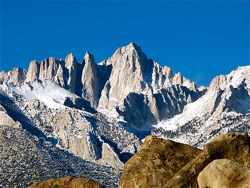 Mount Whitney
If you don't mind driving another fifty miles, there are many campgrounds along Bishop Creek just to the west of Bishop. There are also many places in The Buttermilks area that are close to a creek that are suitable for camping. Please do not camp in The Buttermilks bouldering area. That area is very crowded and is suffering from the impact unregulated camping has caused.
The following links should help finding a good campsite
Horton Creek Campground
Rock Creek Canyon
Inyo National Forest
Bishop Creek and vicinity camping