
-
 11824 Hits
-
 86.37% Score
-
 22 Votes
|
|
Mountain/Rock |
|---|---|
|
|
36.58206°N / 118.10406°W |
|
|
Inyo |
|
|
Sport Climbing |
|
|
Spring, Summer, Fall, Winter |
|
|
4750 ft / 1448 m |
|
|
Overview

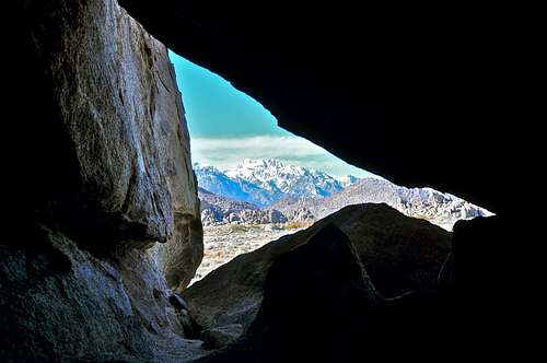
 Inside Whitney Cave
Whitney Cave is a grouping of rock formations in the Alabama Hills area of Sierra Nevada Range, California.
You may wonder what a cave may have to do with the sport of rock climbing. Well, the cave itself has nothing to do with climbing. As I stated in my route page for Capricorn Wall, long before Whitney Cave was explored for its potential as a climbing area, it was used for partying by the local youths. Although this cave is in the outskirts of (Lone Pine Peak), Whitney Cave seems much more befitting, and the early climbing pioneers decided to keep the name.
Whitney Cave is one of the most remote climbing areas in the Alabama Hills. Considering the number of faces available for development, you could say that area is under developed. It seems that some of the energy and effort that have gone into developing, or over-developing, the east and the west ends of The Corridors area could have gone into developing the Whitney Cave area. You could argue that may be we should have left the Whitney Cave area alone for the local youths as their little nook. Suffice to say, both arguments have their own merit.
Select Routes
 Boss Choss, 10d Boss Choss, 10d |  Capricorn Wall Capricorn Wall |  Jackaloo face, 5.9 Jackaloo face, 5.9 |
 Pu Pu Platter Face
 Skylight
To reach two more routes, you need to enter Whitney Cave itself. Across from the fire pit inside the cave, there is an opening like a skylight. If you look up you will see the first two bolts of two separate routes on the face west of the cave. The left one is Skylight, 10c and the right one Pipe Dream, 10b.
To reach the remaining routes, use a narrow slot to the left of the cave to reach an amphitheater of sort. On a flawless face immediately to your right you will see a seam with a line of bolts running alongside of it. This is Jackaloo, rated 5.9. It has a two-bolt anchor. Walk further to the right on huge sloping boulders to the next face, still to you right and south facing. This is Pu Pu Platter. It is hard to see the bolts, but there are four routes on this face. The far right line of bolts climbs a route named Precious Auntie, rated 10a. The remaining routes to the left of Precious Auntie are much more difficult, in the 5.11 range. Across from Pu Pu Platter, there is a huge and uninviting face with a line of bolts. This route is Boss Choss, rated 10d, and starts on low angle rock at first only to turn into a terrifyingly steep rock soon after.
List of the select routes
Select Routes of Whitney Cave area | |
| 1 | Wounded Knee, 10a, bolts, anchor |
| 2 | Capricorn, 10c, bolts, anchor |
| 3 | Dec 29, 10d, bolts, anchor |
| 4 | Happy Cappys, 11a, bolts, anchor |
| 5 | Jackaloo, 5.9, bolts, anchor |
| 6 | Boss Choss, 10d, bolts, anchor |
| 7 | Skylight, 10c, bolts, anchor, this is the left line of bolts starting from inside the cave |
| 8 | Pipe Dream, 10b, bolts, anchor, this is the right line of bolts starting from inside the cave |
 Looking out at Mount Williamson
How to get there

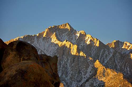 Lone Pine Peak
The first part of the approach is the same as approach to The Candy Store. From the town of Lone Pine on HWY 395 drive about three miles on Whitney Portal Road to intersect Horseshoe Meadow Road. Turn left onto Horseshoe Meadow Road and drive about a mile to just past the last grouping of rocks. Turn left onto an old and narrow paved road for a short distance and left again onto a dirt road. Drive another 200 yards to the crags.
The dirst road that passes in front of Candy Store soon reaches a cattle Gate. Open the cattle gate and go through, but please close and chain the gate behind you. We don’t want the locals to get pissed. Drive to end of the road and park in front of Whitney Cave. Capricorn Wall is a well-featured orange color face on the right. The mouth of Whitney Cave is obvious.
Camping
[img:480439:alignleft:medium:Lone Pine Peak]Although many parties camp within the parking areas of the Alabama Hills, this practice is highly discouraged. The area suffers from mismanaged campsites and blackened caves. There are two campgrounds very close to the Alabama Hills. Lone Pine Campground is further up the road on Whitney Portal Road, and Tuttle Creek Campground is within a few miles up Horseshoe Meadow Road.If you don't mind driving another fifty miles, there are many campgrounds along Bishop Creek just to the west of Bishop. There are also many places in The Buttermilks area that are close to a creek that are suitable for camping. Please do not camp in The Buttermilks bouldering area. That area is very crowded and is suffering from the impact unregulated camping has caused.
The following links should help finding a good campsite
Horton Creek Campground
Rock Creek Canyon
Inyo National Forest
Bishop Creek and vicinity camping