
-
 4384 Hits
-
 84.27% Score
-
 18 Votes
|
|
Mountain/Rock |
|---|---|
|
|
36.60757°N / 118.13369°W |
|
|
Inyo |
|
|
Trad Climbing, Sport Climbing, Toprope |
|
|
Spring, Summer, Fall, Winter |
|
|
4820 ft / 1469 m |
|
|
Overview
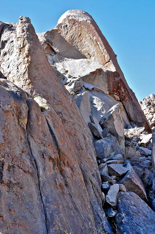 Mon Cherie, on the left and The Loaf, on the right
Truffle Tower is a rock formation in the The Alabama Hills on the outskirts of Mount Whitney in the Sierra Nevada Range., California.
Truffle Tower is a part of the northernmost grouping of rock formations along Movie Road. It consists of two side by side formations with the larger of the two looking like a true tower. The smaller of the two formations seems to get over-shadowed by the larger one, hence you hardly ever see much activity on it. The larger of the two, however, is extremely popular and gets most of the traffic. All the attention is due to one climb by the name Mon Cherie, rated 5.9. It ascends a line of red painted bolts up the middle of a flawless face. The route begins on low angle rock that gradually steepens to a crux move near the top and a welcome set of anchor bolts near the top of the tower. If you are short, you may find the crux harder than 5.9. There are a few much better handholds on the right to help you get past the crux of Mon Cherie. For a number of years climbers top roped the face to the right of Mon Cherie, Escargot, rated 5.8, using Mon Cherie's anchor. On my last visit to the area I noticed that the face was also bolted with its own anchor bolts and ready to be done on lead. Thank you guys for doing all this work. Finally, if you think these routes are all too soft, you can give this new route a try, Metro, rated 10d on the extreme left side of the smaller formation. Have fun.
Truffle Tower is flanked by famous formations such as Hoodgie Wall to its east and a much larger formation, The Loaf to its west. If you are in the mood for a long sport route, you can try Pangborn, rated 10a on The Loaf. You may, however, find getting to the base of The Loaf a greater challenge than doing the climb itself.
The smaller of the two formations that make up Truffle Tower offers a very rare kind of route for The Alabama Hills. This is a crack climb called Rainy Day, Dream Away, rated 5.8. This route requires jamming and placing protection_ two skills that are unusual for climbing in The Alabama Hills. To descend this climb use the anchor for Copyright Infringement a few feet to the left/east of Rainy Day, Dream Away.
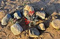 protecting native plants
How to Get to Truffle Tower:
From the town of Lone Pine, California, on Highway 395 take Whitney Portal Road at the only traffic light in town. Drive 2.7 miles west on this road to intersect Move Road. Turn right onto the Movie Road. This road is paved for a short distance then it turns into a dirt road. The first dirt road to intersect the Movie Road heads for Shark's Fin. Drive about a mile to where Movie Road makes a sweeping turn to the right. Just before reaching this turn you will see a dirt road intersecting from the left. Take this dirt road and stay on the right until you see a very large blackened boulder/cave. Park here. Looking in the direction of the west you will see the very prominent Hoodgie Wall a one minute walk away. Truffle Tower is immediately to the right of Hoodgie Wall.
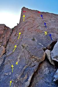
List of the routes
Routes of Truffle Tower | |
| 1 | Metro, 10d, bolts to anchor |
| 2 | Copyright Infringement, 5.7, bolt and gear |
| 3 | Rainy Day, Dream Away, 5.8, standard rack, pro to 4 inches |
| 4 | Mon Cherie, 5.9, bolts |
| 5 | Escargot, 5.8, bolts |
Routes topo
 |  |  |
Camping

If you don't mind driving another fifty miles, there are many campgrounds along Bishop Creek just to the west of Bishop. There are also many places in The Buttermilks area that are close to a creek that are suitable for camping. Please do not camp in The Buttermilks bouldering area. That area is very crowded and is suffering from the impact unregulated camping has caused.
The following links should help finding a good campsite
Horton Creek Campground
Rock Creek Canyon
Inyo National Forest
Bishop Creek and vicinity camping