
-
 5654 Hits
-
 85.87% Score
-
 21 Votes
|
|
Mountain/Rock |
|---|---|
|
|
36.58459°N / 118.1132°W |
|
|
Inyo |
|
|
Trad Climbing, Sport Climbing |
|
|
Spring, Summer, Fall, Winter |
|
|
4630 ft / 1411 m |
|
|
Overview
 Looking out of the main corridor.
Rocky Top is a grouping of rock formations in the Gunga Din area of the The Alabama Hills on the outskirts of Lone Pine Peak in the Sierra Nevada Range, California.
I have written about the Gunga Din area in the past, however, I deem necessary to explain where the name came from. Gunga Din is the name of a water boy in India during the British Colonial occupation. A movie by this name was released in 1939 and the area now known as Gunga Din was a major staging ground and it was used extensively used throughout the movie. Gunga Din area resembles a large amphitheater surrounded by dramatic rock formations such as Temple of Kali and Peter Gabriel Cliff. Other noteworthy formations in the vicinity of Gunga Din are the mighty Alabama Dome to the north, and The Candy Sore to the west.
The largest and the most dominating formation in the gunga Din area is the subject of this page, Rocky Top. In contrast to Thug Wall that seems to have become a party spot complete with much trash and broken bottles, Rocky Top has stayed clean, except for subtle signs of climbers passage. This is mostly due to the difficulty in approaching the base of the rear formations. The main difficulty is that you need to be small enough to fit through the tight slots between some very large boulders. And when you do get through, it's not so easy to bring a six pack along, hence no broken glass.

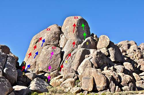
Select Routes
Select Routes of Rocky Top | |
| 1 | Southern Girls, 10c, rounout, Gear to 2.5 inches, anchor |
| 2 | Bodacious, 5.9, rounout, 2 bolts, share anchor with #1 |
| 3 | Chocolate Mice, 5.8, bolts, anchor |
| 4 | Krugerrands, 5.8, rounout, standard rack, pro to 3.5", anchor |
| 5 | Rocky Top, 5.8, rounout, standard rack, slings |
By all accounts Rocky Top was the first formation in this area to be climbed in the early to mid 1980s. For the first ascent of the route Rocky Top, 5.8, Gary Slate, resident of the Eastern Sierras, used only nuts and slings for protection. The "Good Ol" days of climbing with minimal gear were quickly coming to an end. The use of bolts was kept to absolute minimum when the same climber put up another long face route on the largest formation in the back using only two bolts for the entire route.
Nowadays, however, most climbers make their way to the easy to reach front boulder and climb Chocolate Mice. This route is rated 5.8 and nicely bolted to reach a beautiful and safe anchor. The base of this route is small, but it's flat and surrounded by rocks.
Getting there
 Chocolate Mice, 5.8
 Southern Girls on the rear formation
 one of the narrow access slots
How to get to Rocky Top
From the town of Lone Pine on HWY 395 drive about three miles on Whitney Portal Road to intersect Horseshoe Meadow Road. Turn left onto Horseshoe Meadow Road and drive about a mile to just before the last grouping of rocks where you will see a wide turnout into a wide and flat area. Turn left here and stop to read the history of the movie Gunga Din on a plaque. Drive down the bumpy dirt road for a few hundred feet to a much wider flat area surrounded by rock formations. This is the Gunga Din area. Look in the direction of the west. The largest formation seen from Gunga Din is Rocky Top. Head for the boulder-filled gully and squeeze through a very narrow slot for the back formations. Chocolate Mice is in the front formation and does not require going through the slot.
Camping
 Lone Pine Peak
 Gunga Din
If you don't mind driving another fifty miles, there are many campgrounds along Bishop Creek just to the west of Bishop. There are also many places in The Buttermilks area that are close to a creek that are suitable for camping. Please do not camp in The Buttermilks bouldering area. That area is very crowded and is suffering from the impact unregulated camping has caused.
The following links should help finding a good campsite
Horton Creek Campground
Rock Creek Canyon
Inyo National Forest
Bishop Creek and vicinity camping
External Links
<