
-
 4657 Hits
-
 86.85% Score
-
 23 Votes
|
|
Mountain/Rock |
|---|---|
|
|
36.59741°N / 118.12888°W |
|
|
Inyo |
|
|
Sport Climbing, Toprope |
|
|
Spring, Summer, Fall, Winter |
|
|
4810 ft / 1466 m |
|
|
Overview

The first time I visited this area in 2004 there were only two west facing formations with two sport routes on each. After climbing all the routes there I didn't see any reason for visiting the area again, especially since the dirt road leading to the rocks was badly rutted. Fast forward to 2010 and membership in Summit Post; I had to go back. The dirt road leading to the area is even worse now and needs to be hiked unless you can find an alternate dirt road bypassing the bad one.
Compared to 2004, the Hideout is by far more developed now with potential for many more routes. Facing southwest and lying in between the two original formations, you will find two side-by-side towers. The one on the left has three bolts leading to a beautiful anchor. The tower on the right has two bolted routes, one with five bolts and one with four bolts, sharing the same anchor. Route development on these two towers wasn't as much of a surprise as what I found on the northeast face of The Hideout complex.

The East Face
 One Heck of a Lizard, 5.9
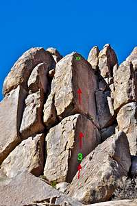 In Memory of Raleigh Collins, 11a
Northwest Face
 #1 is Power Play, 10a, #2 is Whippersnapper, 5.8

Walking further hugging the west facing formations you will come to a large block atop another small boulder. Two of the original routes are on this boulder. Walking further you will pass by the two towers mentioned in this page. Walking further and going right around the formation you will eventually come to the two very original routes established in this area. The route on the left starts from the ground with a rather bouldery move on good holds. This route is known as Power Play, originally rated 5.9 is now up grated to 10a. The one on the right is a face route on loose flakes known as Whippersnapper, rated 5.8 and starts from the top of a boulder.
Getting there

 protecting native plants
How to Get to The Hideout:
From the town of Lone Pine, California, on Highway 395 take Whitney Portal Road at the only traffic light in town. Drive 2.7 miles west on this road to intersect Move Road. Turn right onto the Movie Road. This road is paved for a short distance then it turns into a dirt road. The first dirt road to intersect the Movie Road heads for Shark's Fin. Take this road for a few hundred yards and park in one of the parking spaces for Shark's Fin. Walk up the same road for several hundred yards past The Whitney Boulder to The Hideout.
Camping

If you don't mind driving another fifty miles, there are many campgrounds along Bishop Creek just to the west of Bishop. There are also many places in The Buttermilks area that are close to a creek that are suitable for camping. Please do not camp in The Buttermilks bouldering area. That area is very crowded and is suffering from the impact unregulated camping has caused.
The following links should help finding a good campsite
Horton Creek Campground
Rock Creek Canyon
Inyo National Forest
Bishop Creek and vicinity camping
Dave Daly - Dec 9, 2016 12:24 pm - Hasn't voted
Access To The HideoutIt is possible to drive over to The Hideout. However, recently the BLM has reclaimed the dirt road leading to the Shark Fin in order for sage and other native plants to thrive again. There is a fork in the dirt road once you turn on to it. Take the LEFT fork (the other fork dead ends at a parking area for Shark Fin. Follow the dirt road until you see the Hideout on the right. Be sure NOT to park on the brush though. Limited spots to park near the Hideout.