
-
 4527 Hits
-
 89.01% Score
-
 28 Votes
|
|
Mountain/Rock |
|---|---|
|
|
36.58577°N / 118.10683°W |
|
|
Inyo |
|
|
Trad Climbing, Sport Climbing |
|
|
Spring, Summer, Fall, Winter |
|
|
4635 ft / 1413 m |
|
|
Overview


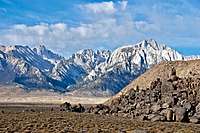
Earthday Dome is a rock formation in the The Alabama Hills area of Sierra Nevada Range, California.
Considering the number of movies that have been made around the rock formations in the Alabama Hills, it's easy to forget that there is a lot more to this area than the famous and popular Movie Road. In fact, a very large portion of the Alabama Hills lies on the south side of Whitney Portal Road, and somewhat isolated from the main areas. On the south side of the Whitney Portal Road we have the Gunga Din Area that includes, Alabama Dome, Temple of Kali, Rocky Top and Peter Gabriel Cliff. Further to the south we have the The Candy Sore with all of its short moderate routes. Then even further to the southwest and removed from the rest, we have Whitney Cave with a gate and a ranch road leading to it. Even more isolated from the rest, with no roads leading to it, is Earthday Dome.
Earthday Dome, clearly visible from the vicinity of the Candy Store, looks quite small and featureless. This dome, however, is not that small and not that featureless. The routes are full sport pitch sizes and a heaven for slab climbers. Starting from the left, the west face, we have the best route on the entire formation. This is "Have a Slabulous Day," rated 5.8 and protected by six bolts to a double cold shuts anchor. This route may seem a bit runout, and it is, but it's not as bad as the routes on the southwest face of this dome.
There are three routes on the southwest face. Starting from the left, we have "Everyday Is Earthday," rated 5.9. If you thought the last route a bit runout, this one will surely scare you. You have only five bolts for the same length of climbing. The next route is terribly runout for the second half of the climb. "Seamingly Cool," rated 5.6, follows a seam on a slab, then you are on slab with a few plates all the way to the top. You may be able to put a sling around one of the plates to protect the face above the seam. The next route is a wide flared crack/chimney system that is gear protected. This is "Green Peace and Greenbacks," rated 5.7.
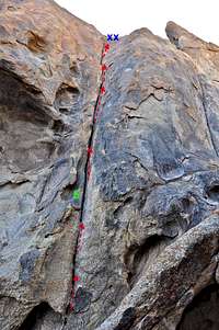
Routes Topo
 |  |  |
 Earthday Dome on the left and the unnamed formation on the right.
There is one more climb in this area but it's not on Earthday Dome itself. There is another formation behind Earthday Dome and the two make a narrow corridor. The next route is located on the west face of this yet unnamed formation. The route climbs a crack in a dihedral most of the way to a short slab near the top. The slab section is protected by one bolt and the lowest part of the crack by another bolt. This is a great one pitch route called "Corner The Market, Lose the Planet," rated 5.8.
List of the routes
Routes of Earthday Dome | |
| 1 | Have a Slabulous Day, 5.8, bolts, coldshuts |
| 2 | Everyday is Earthday, 5.9, bolts, cold shuts |
| 3 | Seamingly Cool, 5.6, standard rack, small pro, long slings, cold shuts |
| 4 | Greenpeace and Greenbacks, 5.7, standard rack |
| 5 | Corner the Market, Lose the Planet, 5.8, two bolts, standard rack, pro to 3 inches. anchor |
Approach
 Earthday Dome seen from near Candy Store
 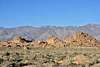 Earthday Dome is the seemingly featureless formation on the left
Make the approach via the The Candy Sore. Walk down the dirt road in front of Candy store to a gate. Go through the gate and make sure to chain the gate shut behind you. From here Earthday Dome is clearly visible to the east and it's about one half of a mile walk on cross country terrane.
How to get to Candy Store: From the town of Lone Pine on HWY 395 drive about three miles on Whitney Portal Road to intersect Horseshoe Meadow Road. Turn left onto Horseshoe Meadow Road and drive about a mile to just past the last grouping of rocks. Turn left onto an old and narrow paved road for a short distance and left again onto a dirt road. Drive another 200 yards to the crags.
Note: On your way to Candy Store you will drive just past Ganga Din Area. This is where the old movie Ganga Din was filmed.
Camping

Although many parties camp within the parking areas of the Alabama Hills, this practice is highly discouraged. The area suffers from mismanaged campsites and blackened caves. There are two campgrounds very close to the Alabama Hills. Lone Pine Campground is further up the road on Whitney Portal Road, and Tuttle Creek Campground is within a few miles up Horseshoe Meadow Road.
If you don't mind driving another fifty miles, there are many campgrounds along Bishop Creek just to the west of Bishop. There are also many places in The Buttermilks area that are close to a creek that are suitable for camping. Please do not camp in The Buttermilks bouldering area. That area is very crowded and is suffering from the impact unregulated camping has caused.
The following links should help finding a good campsite
Horton Creek Campground
Rock Creek Canyon
Inyo National Forest
Bishop Creek and vicinity camping