
|
|
Mountain/Rock |
|---|---|
|
|
46.01276°N / 8.09049°E |
|
|
Piedmont |
|
|
Hiking |
|
|
Spring, Summer, Fall |
|
|
8967 ft / 2733 m |
|
|
Overview
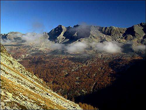
Pizzo San Martino, Saint Martin peak, is a mountain of the wild range that divides Antrona valley from Anzasca valley in the North East of Piedmont.The summit of this mountain has been for long the aim of the pilgrims of the small villages of Vanzone and San Carlo, in Anzasca valley, that used to reach the summit to give homage to the Saint.
A big iron cross posed at the beginning of the last century still adorns the summit and is visible even from the deep of the valleys below.
This mountain is surrounded by an environment where wilderness is still well conserved, it’s normal to meet mountain goats, ibexes, ground-hogs and foxes on its slopes and in the woods below.
The access to the summit is very long from all the sides, especially from Anzasca valley, where the flanks of the mountain fall for more than 2000 meters above Vanzone and San Carlo.
The trail to San Martino is anyhow very pleasant for those who love long hikes among wild and solitary peaks and the wide view from the top embraces all the 4000s of Wallis, the magnificent east face of the near Monte Rosa and all the other summits and valleys of the area.
 San Martino from NW
Getting There
The main trailheads are the village of Vanzone(675m) in Anzasca valley, where you can get by the statal road of the valley starting from the Piedimulera exit of the SS33 Milan-Simplon highway, and the impound of Campliccioli lake(1307m), at the end of Antrona valley.To reach the impound follow the main road of Antrona from the Villadossola exit of the SS33 to the village of Antrona Piana, from here follow the direction of Antrona lake, where a small private road, usually open for everybody, leads to the barrage of the impound.
An alternative starting point is the village of Mondelli(1095m), at less than an half of an our of driving from Vanzone towards the end of the Valley.
From Mondelli a long and pleasant route crosses the range towards East with some up and down till the summit.
Red Tape
No permission is required for any summit in this Area of the Alps range.Huts
 The north face from Alpe Valaverta
On the route from Mondelli, at 2000 meters of altitude.
The path starts from the village and is not difficult, it takes between two and three ours.
Lamè hut.
On the normal route from Vanzone, at 2300 meters of altitude.
Follow the signed trail to the summit, you reach the hut after a long walk, 4 hours, It is anyhow a very useful shelter for who ventures on this long trail.
Routes
All the routes to the summit are very long, especially from Anzasca valley.Above the 'vegetation line' sometimes the path disappears, but a lot of useful signs painted on the rocks over the last years indicate the way efficiently, anyhow be careful in case of scarse visibility.
 | From Campliccioli lake. Expert hikers. The shortest route is the one starting from Campliccioli lake(1300m). From the barrage take the path on the left(south) of the lake that initially follows an old railway used during the building of the impound. After the end of the lake the trail climbs steep to the ruined buildings of Alpe Valaverta. From Valaverta follow the signs on the rock and on the larches that guide toward the rocky cirque under Valaverta pass. The pass is the V shaped saddle at the basis of the E ridge. Climb to the pass and then follow the path that crosses the East face of San Martino till the SE ridge. This last part from Valaverta pass to the SE ridge is not difficult but is very exposed, so be careful. Follow then the easy ridge till the cross on the summit. This route is long and gains more than 1300 meters of altitude, but is pleasant and crosses a variousness of lovely alpine environments. |
 | From Vanzone. Expert and trained hikers. When you enter the village of Vanzone from the main road of Anzasca valley coming from Piedimulera, there is a sign on the right of the road that indicates the trailhead to San Martino. From this sign follow the trail that climbs the long valley of Rio Lasino till Alpe Asinello. follow then the signs to Lamè hut and, passing by the Sfondato lake, across the easy south flank, reach the SE ridge and the summit. The elevation gain is major than 2000 meters, you can use Lamè hut as support point. |
From Alpe Lavazzero, alternative route. Expert and trained hikers.
From Vanzone follow the route that climbs the long valley of Rio Loretto till you reach Alpe LAvazzero, from here you must gain the beginning of the SE ridge scrambling over the steep east face, this part is exposed and can be slippery.
In alternative you can head to Valaverta pass, but the trail is once again dangerous.
Alpe Lavazzero can be reached also by the village of Barzona(688m), some kilometres at South of Vanzone, following the pleasant but long trail of Val Bianca.
This route is the hardest and longest.
From Mondelli. Expert hikers.
From the solitary village of Mondelli follow the easy trail to Longa hut, then take the direction of Loraccio pass at North. After a first unnamed pass you enter the hanging valley under Pizzo Lamè. Follow the signs to Lamè hut and then reach the summit by the trail coming from Vanzone.
This route is very long (with also a pair of up and down that arise the rate of elevation gain) but pleasant, you can break it in two days by sleeping at Longa hut or at Lamè hut.
The combination of this route with the one coming from Vanzone or from Campliccioli is a great trekking opportunity in a very savage environment.
 3D map
External links
Valle AntronaOfficial site of the valley. Informations about the trails, and the accomodation plus some useful phone number.
San Martino
A report of the ascension from Antrona, with a map and some images.
 Valle dell'Asino seen from the summit