
|
|
Mountain/Rock |
|---|---|
|
|
61.61650°N / 8.29854°E |
|
|
Mountaineering, Scrambling |
|
|
Spring, Summer, Fall, Winter |
|
|
7575 ft / 2309 m |
|
|
Overview
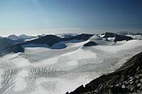
 NE Face
Store Tverråtinden is located in the Jotunheimen Area and lies just south of Galdhøpiggen. The peak is the 18th highest in Norway when counting peaks with a prominence of greater than 100m (Tverråtinden's prominence is 190m). It is the highest point on a ridge that runs in an east-west direction and includes Midtre Tverråtinden (2302m). It is surrounded by a broad glacial expanse although can be climbed with minimal technical difficulty from either Spiterstulen to the east or Geitsætre to the west. The Svellnosbrean Glacier lies to the north, the Tverråbrean Glacier to the south and the Nørdre Illåbrean Glacier to the west. The most impressive aspect of the peak is the near-vertical north-east face which drops down in one sweep to the Svellnosbrean Glacier. Whether this is dry enough for rock climbing I could not tell. (if anybody knows better please share!)
Routes
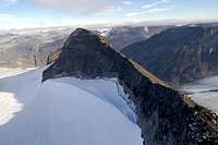
 Approaching the summit
It’s possible to climb the peak with minimal technical involvement by starting from Geitsætre and ascending the Nørdre Illåbrean Glacier and up the Western side. This page provides excellent information on the route with an accompanying map. The climb takes 5-7 hours with over 1000m of ascent.
An alternative route begins from Spiterstulen (1106m) and climbs the Svellnosbrean Glacier before ascending the peak from close to Svellnosbreahesten (2181m). The Svellnosbrean Glacier’s lower slopes form a maze of crevasses that take time to negotiate although easy to navigate for anybody with glacier experience. Higher up it is less fractured and the gradient very mild. The final climbing is over loose rock and not difficult. The total vertical climbing distance is 1200m and suitable fitness is required.
 Store Tverråtind viewed from Galdhøpiggen
The most interesting way to climb the peak is in conjunction with Midtre Tverråtind (2302m) immediately east along the same ridge. This makes for an enjoyable high traverse that takes up most of the day. On the western side of Midtre Tverråtind (2302m) is a short pitch of fixed rope needs to be ascended / descended over steep sections of rock. The ascent isn’t suitable for non-rock climbers but anybody adept with basic hand-jamming techniques will not find it too difficult. The rock pitch can be avided by skirting via the south side however there is plenty of loose rock to contend with.
Getting There
 Crevasses on the Svellnosbrean Glacier
 The mountain lies in the heart of Norway equidistant from Oslo, Bergen and Trondheim. Lom is the gateway town for Jotunheimen. Nor-Way has about five buses a day from Oslo which go via Oslo Gardermoen airport. NSB have trains from Oslo to Otto from where there are connecting buses to make the short ride to Lom. Bus times coordinate with train arrival times. From Oslo take the E6 to Otta (308km) then Road 15 to Lom (64km). From Lom take Highway 55 (Sognefjell Mountain Road) and then turn off for either Spiterstulen or Leirvassbu (for Geitsætre). Both are sign-posted. In the summer there are buses that travel along Highway 55 between Lom and Sogndal. Out of season you will need your own transport otherwise prepared to hitch (or walk!).
Geitsætre is 5.7km south of Highway 55 on a road that terminates at Leirvassbu whereas Spiterstulen is 35km from Lom and about 15km south of Highway 55. The Spiterstulen road is open year round. The road to Geitsætre is usually open in winter up to 1-2 km south of Geitsætri according to Eric S.
 View North to Galdhøpiggen View North to Galdhøpiggen |
 View South across the Tverråbrean Glacier View South across the Tverråbrean Glacier |
 View East to Midtre Tverråtinden (2302m) View East to Midtre Tverråtinden (2302m) |
Red Tape
 Lower slopes of the Svellnosbrean Glacier
There are is no red tape for climbing in Norway.
The peak falls within the Jotunheimen National Park and you must observe park rules.
There is a 50 Kr fee for cars using either the roads to Spiterstulen or Geitsætre.
Remember not to camp too near buildings (see Camping and Accommodation section below)
Norway is an easy country to visit. Visas are not required for most nationalities but check your embassy if in doubt.
Camping and Accommodation
 Spiterstulen
Lodges are available at Spiterstulen and Leirvassbu. Spiterstulen is perfect for climbing the mountain from the east but Leirvassbu is about 10km south of Geitsætre.
Lodges
Spiterstulen Lodge
Staffed private lodge with 120 beds.
Season: About 1st May to mid-October
Email: post@spiterstulen.no
Tel: +47 61 21 14 80
Fax: +47 61 21 19 72
 Store Tverråtind from Svellnosbreaheston (2181m)
Leirvassbu Lodge
Staffe private lodge with 190 beds
Season: Year Round
Email: lvassbu@online.no
Tel: +47 61 21 12 10
Fax: +47 61 21 12 11
Wild camping is legal in Norway meaning those on a budget can minimise the expensive costs by taking a tent. You are not allowed to camp within 150m of roads or buildings however. In the Spiterstulen area the rule is slightly different. You must either camp on the campsite on the east side of the footbridge (50 Kr per night) or camp over 1km away. Camping within 1km may prompt a visit from Spiterstulen staff to collect a camping fee.
When to Climb
 Compass?
This depends on whether you plan to use skis. Without skis the peak is best climbed between March and September when snow levels have sufficiently receded. Wet conditions will not make the climb any more difficult. If you plan to ski then the season lasts until about April. The last few hundred metres may be too rocky for skiing but the Svellnosbrean Glacier should be fine.
Maps
Suitable maps are easy to purchase in Norway. Most book shops and DNT offices sell maps. The tourist office in Lom can also sell you maps. These are the maps I used but there are others.Turkarta Nr.2655 Galdhøpiggen 1:25 000
Turkarta Nr.2502 Jotunheimen Vest 1:50 000
External Links
Ski descent of Store Tverråtinden (In Norwegian)Jotunheimen Tourist Office
West Coast Peaks
Scandinavian Mountains
These are two excellent English guides to the mountains of Norway.