

|
|
Area/Range |
|---|---|
|
|
63.39150°N / 12.30470°E |
|
|
Hiking, Mountaineering, Trad Climbing, Sport Climbing, Toprope, Bouldering, Ice Climbing, Aid Climbing, Big Wall, Mixed, Skiing |
|
|
Spring, Summer, Fall, Winter |
|
|
Overview
 Kebnekaise and the Swedish mountains at winter. Photo by turot
The Scandes mountain range starts in the south tip of Norway, enters Sweden at Dalarna, and then follows the border all the way past Treriksröset, where it starts including Finland, up into the very north, (Ultima Thule) where it falls out into the Arctic Ocean.
(Treriksröset means "The Cairn of the Three Kingdoms" and is the spot where Norway, Sweden and Finland meets, (even though Finland is an republic nowadays.)
 Map of the Scandes and areas within.
In the west the chain falls into the Atlantic and in the east it just flattens out, except in Ångermanland, where it goes straight out into the sea - Östersjön. The area is called the High Coast - Höga Kusten, and it's a gorgeously beautiful place - like a softer version of Lofoten. Not so high, but some good rock climbing may be done there.
Links to specific area maps:
About Laponia The area includes the national parks of Abisko, Padjelanta, Sarek, and Stora Sjöfallet. Lapland is Europe’s biggest integral natural landscape with an area of 9,400 square kilometers, but it is not all mountaineous.
The arm of Finland. More than 60 % of all Finnish fells are located in Enontekiö municipality. Arctic flat-top mountains and large wilderness areas is the characteristics of the place, identical with area shown in the map below, of the Finnish mountains.
Geology
 Kaskaspakte, Sweden. Photo by soderkisen. Kaskaspakte, Sweden. Photo by soderkisen.The Skandinavian mountainrange, the Scandes, is a part of the Kaledonian mountainrange and it is 1700 km long and goes all the way to the Brittish Isles. It was created sometime 420-380 miljon years ago, when the North American contintal plate krashed with the Baltic Shield. Scandinavia met Greenland, and a mountain chain rose. The sediment on the sea bottom was pushed up to a mountainrange high up over the west border of Scandinavia. The mountains were very high and sharp, like the Alps and Himalayas is now. This chain was eroded down to nothing during a period of 300 miljon years. 250 miljon years ago, it was divided into smaller pieces, when the Atlantic ocean was created. One finds peices of it in the Appalachians, Scotland, Skandinavia and on the east coast of Greenland. 70 miljon years ago the western part of the Baltic Shield was lifted up the rooots of the chain was lifted up, to create the mountain range that exists today. One can se the chain quite clearly on this satellite picture below. It is all white and snowy, except for the part that makes an offshot across to Östersjön. The sea is partly frozen between Sweden and Finland, the entire Finnish coast is in ice. Minerals and stonesGranite and gnejs in the chain. In the south, Jämtland, one finds basalt och magmatic diabas mostly. In Sarek and Kebnekaise there are also metamorphic stones like gnejs and slate. In the highest mountains, amphibolite dominates, en metamorph kind of stone.  The granite of Bohuslän, south of the range was created 900 milion years ago. The iron ore of Norrland was created out of hot magma. Volcanic islands was formed with ore of iron, copper, lead, zink, silver and gold. |
Mountain areas
This is the part where more information will be added in time, but there are few "groups" defined and commonly used. They simply need to be invented and I would really appreciate help on that! You have an opinion, please use additions... (Neither will I repeat information that can be found on the mountain or other group pages, that's just a waste of space and work.) Half of Norway's total area lies above the timberline.  Photo made last summer in the national park Jotunheimen. Photo by pvangeenen Photo made last summer in the national park Jotunheimen. Photo by pvangeenen |
There are smaller groups within the chain, like the Jotunheim area. Map to the National Parks of Norway, choose Jotunheim. The mountains in that group are: Galdhopiggen Glittertind Store Skagastolstind Sentraltind Tjornholstind Store Smorstabbtinden Torfinnstindane Fanaråken Steindalsnosi The mountains of Lofoten on SP are: Svolvaergeita (The one with the jump) Vågakallen Lofoten Islands Saana and Halti, the two highest mountains of Finland are both located in Fell Finland. |
Red Tape
 Panoramic view into the Lysefjord from near Kjeragbolten. Photo by mpbro. Panoramic view into the Lysefjord from near Kjeragbolten. Photo by mpbro.Residents from some countries needs visa. Information about visa to Norway Information about visa to Sweden Information about visa to Suomi Finland General information when visiting Scandinavia: The official Swedish website for travel and tourism Information in plenty of languages and information about out-door stuff, as hiking & trekking or different kinds of skiing. Telemark, for example, the free-heel skis, have been traditionally used in Sweden and Norway by hunters and farmers. The official Norwegian website for travel and tourism Plenty of information about outdoor activities. Climbing is a most normal activity for Norwegians. The official Finnish website for travel and tourism. Also a very out-doorsy country... they have a glass-igloo hotel in Lapland, for watching the Aurora Borealis - very cool. |
National parks
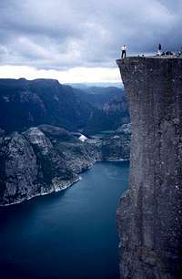 Preikestolen, Norway. Photo by PeterCorneliusSpaeth Preikestolen, Norway. Photo by PeterCorneliusSpaethThere are several national parks within the range. Info on the Norwegian national parks, the Swedish, and the Finnish ones. Starting with the parks in Norway: Hardangervidda mountain plateu Dovrefjell/Sunndalsfjella nasjonalpark, Dovre nasjonalpark, Rondane nasjonalpark Oppdal nasjonalpark Sweden: Töfsingdalen Sånfjället Björnlandet Skuleskogen Pieljekaise Padjelanta Sarek Stora Sjöfallet Abisko Vadvetjåkka Suomi Finland: Lemmenjoki nationalpark Pallas-Yllästunturi nationalpark |
Camping
 Stetind, Norway. Photo by darinchadwick Stetind, Norway. Photo by darinchadwickIn Norway: 150 meters is the closest from a house. The Norwegian Allemansretten - in Norwegian. I am searching for it, in English. Norwegian Camping Guide Visit Norway's (the official tourist organisation) Camping In Sweden: not on anybody's yard or within sight if border is unclear. One or two nights is allowed. Common Right of Access Rights and Regulations in Finland: you may stay one night if uninhabited. One needs permission to make a fire. You may pick berries and mushrooms for your own daily needs only. (Now, when you see the conditions in reality, and realise that "uninhabited" in this part of Finland, means that you have several hundreds of kilometres before there is a house, you probably will venture to make a fire without asking. Just be careful,is my advice. Use your common sense.) |
Cabins
Finland: In the wilderness there are both free and rental cabins. Among the free cabins the wilderness cabins are the most known, they are situated in roadless land in the northen and eastern parts of Finland. There are also the daybreak cabins, and the open peat- and log cots are mainly for daybreaks, but can give protection if needed at night. The locked and bookable rental cabins guarantee you a bed for the night. There are two kinds, depending for how long time one plans to spend in the cabin. Map to cabins. They have great and thorough information about cabins, but it's in Finnish. This is a bit shorter. But, if you hover the mouse above a cabin on the map, you'll get the number and the name and if you click on that name, a pdf will open with a good and detailed map. A list of ALL cabins in the very northern-most part of Lapland. | ||||||||||||||||||||||||||||||||||||||||||||||||||||||||||||||||||||||||||||||||||||||||||||||||||||||||||||||||||||||||||||||||||||||
Sweden: STF, The Swedish Tourist Organisation is one of Sweden's largest voluntary organisations, with about 330 000 members. It operates 315 youth hostels, eight mountain stations, and about 40 mountain huts in remote countryside. The huts listed below belongs to organisation, they are not private.
Then there are cabins, sometimes unmanned, sometimes there's a cabin-host. There one gets room by who arrives first. If full, you may sleep on the floor. If it says "Kungsleden" (The King's trail), its northern part from Kebnekaise and northward towards Abisko, is the most popular wilderness trail there is in northern Scandinavia. You will not be alone, if you walk that in July. Rest of the year, maybe. Those cabins are therefore most popular too.
[img:21604:alignleft:medium: Sentraltind (in front) and Storen (behind) as seen from Styggedalstind. Photo by LS.] | ||||||||||||||||||||||||||||||||||||||||||||||||||||||||||||||||||||||||||||||||||||||||||||||||||||||||||||||||||||||||||||||||||||||
Norway: In the Narvik area, the mountain hiking organisation, NOT has 22 cabins. It's an non-commercial voluntary member's organisation. The cabins are open to all. You can read about the rules, maps and all kind of information on their site. Those lying close to the Swedish border can be seen on the STF maps too.
The Norwegian Mountain Touring Association (DNT) has budget accomodation at more than 400 mountain cabins all over Norway, for members: 43 staffed lodges ( with all kinds of facilities), self-service (provisioned) cabins, often with a warden in high season and 185 unprovisioned cabins. One can buy provisions at the lodges and the provisioned cabins. The huts are too many to list here, but one can make a search on the website. | ||||||||||||||||||||||||||||||||||||||||||||||||||||||||||||||||||||||||||||||||||||||||||||||||||||||||||||||||||||||||||||||||||||||

Fishing
| [img:125852:alignleft:small:Breidtinden, Bodö, Norway. Photo by me.]If you want to go fishing, you'll need this: In Finland, if you're older than 18, you'll need a personal state fishing license and permission from the owner of the fishing grounds. Everything about fishing in Suomi Finland In Sweden,one is allowed to fish freely with hand gear along the coast line and in the two largest lakes, Vänern and Vättern. Numerous links about fishing in Sweden, in English & Everything about fishing, but in Swedish... |
In Norway, The guide to sportfishing in Norway.. It seems to be a very informative site. |
visentin - Nov 5, 2009 10:23 am - Voted 10/10
etymologywhere does the expression "The Scandes" come from ?