
|
|
Mountain/Rock |
|---|---|
|
|
61.37388°N / 8.57842°E |
|
|
6952 ft / 2119 m |
|
|
Overview
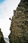
Torfinnstindane is a very popular ridge traverse in Jotunheimen, Norway. The mountain consists of three summits (Eastern, Central and Western summit). Normal route is exposed but not difficult.Route east to west: (II+) - normal route:
Start at Torfinnsbu. Easy scrambling up to Eastern Torfinnstind (I-II). Continue to Central Torfinnstind starting with a rappel (II+), then easy scrambling directly up (II). From Central summit there is 3 rappels. The first one 25 meters (IV), the second one 15 meters (II) and the third one 25 meters (III). Then easy scrambling up to Westeren summit (II). From there its easy going all way down again to lake Bygdin.
(I have added UIAA climbing grade also after rappels just to inform about the effort required to climb it up again...)
Route west to east: (IV)
In the opposite direction. Requires climbing up to grade IV (one section). See description above.
Notice: The Norwegian ratings mentioned above is a little bit harder han UIAA
 |  |  |  |  |
Getting there
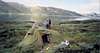
It's approx 250 km by car/bus from Oslo to Lake Bygdin. From there you can either walk for 3 hours to the hut Torfinnsbu or take the boat.Notice! The boat only have 2 departures a day, and it's only in service from July to early September.
 |
When to climb
Winter season:Not recommended because of avalanche danger.
Summer season:
From July to September.
Camping
Stay at the mountain hut Torfinnsbu.A good alternative is to bring your tent, and camp 0,5 - 1 km in easternly direction of the hut.
 |
External Links
- Torfinnstindane (Aug-2003)
Pictures and info about climbing Torfinnstind
snurr - Apr 12, 2005 8:04 am - Hasn't voted
Untitled CommentView this link for boat transportation on lake bygdin
http://www.jvb.no/bitihorn/bitihorn.html