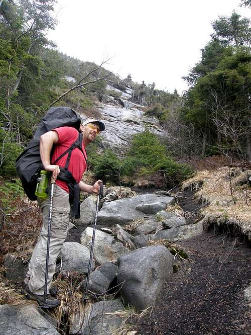
Our first task on the slide was to rest, eat, drink and take photos of the slide once we walked through the small field of blow-down and rubble at its base. We discussed and photographed the area from where we’d emerged. Allen Mtn. offered itself as a subject along with its skirt of fir waves…areas of total destruction from past furies. The runoff tasted wonderful as I refilled my platypus and mixed some lunch: dehydrated macaroni and cheese.
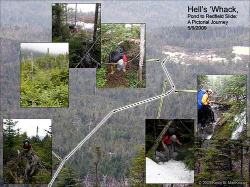
I would break this slide down into four sections:
1.Bottom section of moderate grade (30-35 degrees) consisting of small ledges and slab.
2.Upper bottom made of more ledges, higher and more grade.
3.Mid Rubble connecting lower to upper and where the slide direction changed.
4.Upper Section made of increased ledge climbs and a divergent wedge offering two climbing routes
5.Headwall and cliff.
Twenty minutes found us ascending the slide which is covered in the dreaded red algae along with some green mixed in to keep it Christmas like. We paced ourselves for to continue what was already a strenuous day. Even wet, the red and green algae offered plenty of traction, though it did get a bit slippery up higher as I fried the traction in the flow of the runoff. Striated cracks and a largish dike intersected the slide at a diagonal. The sun broke through intermittently and I hoped for the best when we approached the nearly vertical headwalls higher up.
![Redfield Slide]() Redfield Slide from below.
Redfield Slide from below.
I wanted to see if this was a viable route in wet weather as well as dry. I would say it is, at least for our purposes. We turned back in awe when looking upon the woods to the not so distant pond…it seemed impossible that it took two hours to navigate woods. They really didn’t look thick from a distance. Neil Luckhurst stated that his trek from McDonnell to Redfield Slide found him on meadow-like areas. We were hoping to employ these as a possible route which we’d first view from the slide. His trek was during late winter and I can only assume that he was on top of the blow-down fields because the only open areas we spotted were areas of destruction and horizontal tree falls.
The middle portion of the slide closed in with debris including soil and growth as the slide changed direction by about 35 degrees toward the pond. The width narrowed as more vegetation was present before it opened back up onto the moderately steeper upper portions below the headwall. It was by no means precipitous, but I used switchbacks to navigate the cracks to ease the ascent. WWBF and I traded my camera back and forth to get pictures of each other and none too soon. Our lazy ascent was soon to take a more urgent turn.
![Redfield Slide]() Redfield Slide nearing the headwall.
Redfield Slide nearing the headwall.
The first portion of the headwall was climbable as the diagonal cracks offered multiple hand and footholds much as the small ledges offered below. Suddenly, WWBF noted that the area had become uncannily quiet. The last time he said a comment like that was on Santononi’s Twin Slide before a storm set upon us. This time was no different except I was covered in full rain gear and didn’t suffer from the cold as before. Instantly, the wind broke the silence and rain began, lightly at first. The headwall developed several small trickles before becoming thoroughly soaked in runoff. I opted for the conservative way around the edge as Rico scaled the rough face. As usual, I probably chose the most difficult way in the end. He had no problem and reached the top as I was grappling with several small trees and a face full of blueberry bushes as the face became nearly vertical. A sudden deafening crack moved me into high gear as I pictured a bolt of lightning parting my butt. The rain was now a deluge and we had the final cliff to navigate.
Both of us opted to take to the right-hand route between the stone and trees for most of it. An opportunity for a small climb gave me a little exposure before plunging back into blueberry bushes and cripplebrush. WWBF came up next as I shot a video of his wet climb and listened to the wind assault his pack cover. Our next obstacle was a short bit of cripplebrush and the summit.
WWBF's Account:
The slide itself was quite nice. We needed to watch our footing on some of the red algae, but it was good grippy rock. The slide got steeper as we ascended, and a simple slab walk had turned into a steep grind with Class 3 ledges. At this point MudRat exclaimed that the winds had changed. I added, “And it got quiet”. A couple minutes later, just below the headwall, it began to sprinkle. I thought it was just a passing shower, but decided to glance back over the valley just to make sure. Instead of some low clouds, I saw a wall of water quickly advancing toward us.
We donned our raingear, and began up the headwall in typical fashion… MudRat along the side, me straight up the middle. Halfway up the headwall, it began to pour and thunder. I wasn’t overly concerned though, because the rock was good, my hands were warm, and the thunder was cloud-to-cloud. A short bushwhack at the top of the headwall lead to the base of a cliff. If I weren’t wearing a full pack and it wasn’t raining, I’d entertain finding a route up. But based on conditions I was happy just to angle up along the base to the top of the cliff. The next move required that we use a foot crack to angle back on top of the cliff to a small 6-inch mossy ledge. MudRat performed the move without an issue, so I thought it’d be easy for me. Obviously, he thought so too, because he began videotaping me. I found the crack to be fine, but when I stepped on the mossy ledge, it flaked off and tumbled down the cliff. MudRat’s video captured my expression perfectly. I was still secure on the crack, but had difficulty finding a handhold that I could use for proper leverage. It seemed every good handhold didn’t allow for necessary leverage, and every place where I could get leverage didn’t have a handhold. I asked for MudRat’s help, and he provided a foot for me to grab. Cloud-to-ground lightning now began, and was striking with more regularity as each minute passed.
All Hail Redfield
![Redfield Slide]() Redfield Slide nearing the headwall.
Redfield Slide nearing the headwall.
The events that occurred on the summit will forever be burned in my memory on several different levels. It was a lesson, a trial, a testament (equip) and adventure rolled into one. It’s not an experience I’ve ever dealt with and it’s not one that I’d knowingly seek again…
Lesson one: Be prepared for anything on a hike in the Adirondacks. It’s a statement I preach and believe and usually take to heart. I was (almost) fully prepared, but found myself short in one area because I didn’t anticipate conditions correctly. The north side was our “escape route” against re-bushwhacking our way back to Allen as was the original the plan. We should have had snowshoes. They would have alleviated some problems, but not all.
The summit experience was a testament to just how comfortable proper equipment can make a hiker and also a testament to the incredible power and changeability of weather and mountain conditions.
We arrived on the summit ridge after a push through the tight trees of, perhaps, twenty feet. The woods were reminiscent of last year’s bushwhack up the west drainage from Cliff Slide. The ground was a rolling level grade with varying degrees of blow-down and boulders as is typical on many of the summit ridges. The rain had briefly abated, but the sky grew dark to the level of dusk though it was only around two p.m.; a cold gray blanket pressed from overhead, but we needed to find the summit or at least the trail. We made our way west. (Buzzer sounds….wrong direction).
The walk began in earnest and without much thought that perhaps we were proceeding incorrectly in the low visibility. We couldn’t travel fast as the snow was up to four foot deep in spots and rotten. It supported my frame about seventy-five percent of the time and WWBF’s much less. I began to feel like Legolis in the move Lord of the Rings: able to walk on the snow’s surface while the dwarf and hobbit fell through. The dark clouds’ bit was as bad as their bark as thunder began cracking the air just seconds after the lightening. It was close and relentless. My last bout with a serious thunderstorm was in FL on the flats of the west coast near Captiva. My most recent was on top of Wright Mountain last year. This storm topped all experiences of my past and the time between flashes and thunder was decreasing. The herd path was not in sight.
![Redfield Slide Top of Cliff]() Redfield Slide nearing the headwall.
Redfield Slide nearing the headwall.
WWBF second guessed our direction after a hundred or so yards and maybe ten minutes. I was feeling that something was wrong as well. We followed our postholes back the other way and after some time found the summit boulder right where we left it last year! I jumped up on top in time to see a break in the clouds and Allen Mountain in the distance. The thunder still echoed. WWBF suggested we move off the mountain; I was already on my way down from the rock. I was not panicked so much as cautious. Only a thin (now torn) mesh and a pair of socks stood between my feet and the snow, but I’d been active enough that my feet were cool, but not cold…yet.
Stupidly, I did not account for the amount of snow on the top or the resultant spine of snow on the trail and thus didn’t have snowshoes. As hikers snowshoe or ski the snow throughout the winter on paths, it compresses and, as such, is usually the last to melt. It consisted of about a four inch beam of partially rotten snow and footprint compressions. The sides taper off until ground level or more snow meets the base. As the slope of a trail increases the spine frequently covers the snow runoff which eats it away from underneath. This was the case on Redfield. Consequently, you don’t know which show is rotten or supportive until you apply weight…therein lies the “fun”.
The snow spine on Redfield was several feet high and nearly level with the surrounding snow at times. We lost the trail more than once. As the grade first increase, the gates above opened in one of the worst torrents I’ve seen in the northcountry; so much so that I found myself startled. Trees in front suddenly just disappeared. I forgot the shock of so much instant rain when something hard and painful hit my head. I yelped an, “Owe!” As instantly as the rain began, so did the hail…penny sized hail not just little balls. Thousands of “marbles” danced off the spine, trees and WWBF. I uttered aloud, “You’ve got to be freakin’ kidding me!” It was surreal and thrilling in an “I wish this was on T.V.” sort of way.
Our pace remained the same: less than ½ m.p.h. (our normal is about 3.5). Take two steps, fall through the snow: take two steps; fall through the snow. Again, my weight worked to my benefit, but for the hundred falls I took, WWBF took many more again. WWBF is LOUD when he falls in frustration; frustration that began before the summit. I looked back each time I heard him to check, but tried to keep my glances private. Several times, I watched him push his way out of waist deep holes and once from his armpits. I warned him once, of an area where the runoff stream was five or six feet below the top of the snow bridge. There was already a hole and the stream was at least a foot in depth below. It was still hailing in a torrent, but the size had decrease to ¼ or in or so and was not painful as the size decreased with elevation. Amazingly, my core was still warm, but my feet were beginning to get painful from the cycle of submersion in the water and then snow. Eventually it became packed on top of my foot and behind my heel.
Time didn’t function normally and the whole experience was surreal, but after what seemed a lifetime, WWBF announced that we’d only covered a quarter mile in about thirty minutes. Situations like this are why snowshoes are required if there’s more than eight inches of snow. It puts hikers in jeopardy as well as those who do the rescuing. Subsequently, the following day I heard that three women were rescued from Mt. Jefferson in Vermont during the same storm. I wondered how we were going to make it down as several points, but there was little choice no matter how uncomfortable or unhappy I felt. As long as we kept moving, the experience would end.
As the slope increased, it told us two things: we were making progress and things were going to get more difficult. The trail up Redfield is, in essence, the runoff gully, A storm was in the process of dumping over an inch of rain and snow was melting. The snow spine became less and less stable. It collapsed several times into the torrent that was now the path. We were forced to bushwhack parallel to the path and what I, for the first time, called a dangerous flow. It was several feet deep and descending a grade of thirty or so degrees. It was fast, cold and violent against the rocks and sides. It picked up additional force with each tributary. After an hour and a half it was still hailing and we’d still not intersected Uphill Brook, but we did know it was getting close.
Roughly two hours into our “adventure” down Redfield, we reached the final descent of the drainage into Uphill Brook…the steepest, rockiest part. The flow was wider and faster. Larger tributaries contributed to the issue at this area. We’d descended on the east side and now needed to cross. The increase width did mean that it was more shallow than previously. After finding a large rock under the water, I put a first foot in to test the grip. I committed and took the necessary steps to cross then jumped into the snow on the other side. A few more acrobatic type moves involving trees and a small cliff found us at the flag where the trail breaks off and leads to Uphill brook. Uphill made the runoff look like a mere trickle. It was awe inspiring. A picture is worth a thousand words, but I my camera had broken from the day’s events. We were on the downhill leg, but far from “out of the woods”. I was mentally and physically feeling the wearing effects of the cold.
Snow and now ice still plagued the path and because of the water level, we were forced to bushwhack around certain areas where the path enters the “brook”, but our pace was beginning to increase. For those who know the area, the large waterfall that the path climbs next to was an amazing sight!
I’d taken a few spills here and there throughout the day as usual, but nothing unexpected especially given the conditions. My next steps changed that entirely. After a cliff climb, hours of crawling through blow-down and cripplebrush, hiking a snow spine without proper gear, lightening and hail; it was a small wet log that injured me. I stepped and hit it perfectly incorrectly! I found myself face down in a stream on a tangle of roots with the water running down the inside of my jacket from neck to waist. I’d pinned my thumb and arm under my body and thought I’d broken a rib from the painful breathing. (After a few days, I realized that I’d just bruised it, thankfully).
WWBF caught up to me as I was coming to my senses. I stopped every few hundred yards or so to get my breath as a wrong twist stabbed my left side. We were in the gently sloping woods at the bottom shortly after, just yards from the main trail. I suddenly noticed that the sun was shining on the fog drifting from the ground and the sky over Redfield was a bright picturesque blue. I wouldn’t have been surprised if a half dozen robins danced in unison across the path before me and a unicorn trotted out of the woods as in some Eden-like domain. Timing works its own sadistic humor.
Anyway, we reached Uphill Leanto at 6 p.m. A little over a mile and a half had taken three and a half hours and tested our metal along with a few other parts. We were both very cold and I was shaken from the fall. I simply wanted to get to the truck, but that was another seven or eight miles. I feared not being able to move much in the morning with a pack on. As we continued along the *$*$**# snow/ice spine to Lake Colden, I had two distractions: WWBF and the incredible Opalescent in full fury.
The Opalescent has always been calm, clear and pristine in its traverse through various chasms, incredible falls, slabs and flumes. Today it sounded like a dozen tornados. It made Uphill Brook look calm and stands in my mind as a testament to one of nature’s greatest forces. At the beginning of a notable chasm, we watched tons of water drop violently only to hit and be thrown 15 feet upward into a cliff wall while sending flumes of mist high into the air. Spectacles such as that dotted the way for over a mile. The path travels within feet of the river, sometimes at the top of cliffs and other next to our feet. It was even with the path at several junctures. I note this because it’s usually many feet below. It’s also important to note that this is the upstream portion of the same river we crossed the previous night! A suspension bridge marked the end of this section and Lake Colden. The water was about four feet below the bridge, again, for those who know the area.
Less than an hour later, we found ourselves eating dinner during twilight in a leanto at Flowed Lands. WWBF suggested we stay the night there. I was very concerned about my rib, but acquiesced when the rain began once again. I spent another cold night, but this time put on additional clothing and pressed two hand warmers against my carotid artery for warmth. My mood improved with food and I was thankful for Rico’s calm attitude which kept me the same in turn. As we discussed the day’s events, WWBF commented that he wasn’t sure if anything else could happen. I responded, “Only a panther attack…”
WWBF's Account:
A few feet later we were on the treed summit ridge. MudRat said the summit appeared to be off to the left, so I followed him. After a few minutes of wandering, I questioned his judgment. I glanced at my GPS, but it showed us one-quarter mile southwest of the summit ridge, which I knew wasn’t right. The storm must have been interfering with the signal. We decided to backtrack, and found the summit about 25 feet from where we appeared on the ridge!
Lightning was getting more frequent, and it began pouring once again. We found the herdpath, and thus, we thought, salvation. The problem is that a hip-deep snow spine covered the path. The spine was only about 3 inches wide, so I decided to try hiking on the very edge of it. This option didn’t work too well, and every few steps I plunged hip-deep into snow, wrestled myself out, gained my balance, and then plunged again a few feet later. This continued for about five minutes. Lightning was now cracking all around us (though nothing right on top of us, as there were no flash-bangs), and thunder was a continuous rumble. And then it began to hail.
I noticed MudRat was using the “balance on top of the snow spine” method, which I began to employ with limited success. The fact that I weigh about 30 pounds more than MudRat meant that I broke though the spine more often, and I was getting very frustrated. The constant plunging was tiring enough, but the hail and the lightning added to my mental exhaustion. I knew I couldn’t slow down, however, so I kept marching (plunging) on. I was surprised that the storm had lasted so long. It was no longer hailing, but frequent lightning, continuous thunder, and pouring rain still remained. It had taken us one hour to go one-third mile, and we still hadn’t descended off the mountain’s upper ridge.
We finally reached the section of path that generally followed in the drainage of Uphill Brook. At first I was relieved, knowing that we would be descending in earnest, and hoping that the snow spine would disappear. What I didn’t expect is that the typical 5-foot wide, gently cascading brook would be a 20-foot wide raging torrent. MudRat led us into the woods on the right side of the brook, but I knew the trail exited the drainage on the left. This typically wouldn’t be an issue, but the brook was getting wider and more powerful as we descended. We decided to cross the brook before it got much worse, and picked up the path on the left side. Whenever the path would enter the drainage, we’d have to bushwhack along the side. Now even crossing the tributaries became sketchy. At one tributary crossing, I stepped on what I estimated to be a 500-pound boulder, and noticed it was rocking in the current.
We finally entered the woods for good, and soon found ourselves at Uphill Lean-To where we ate and rested. It had taken us nearly nine hours to hike three miles. We started to get cold, and made the decision to head down to Lake Colden instead of staying at the lean-to. I was glad MudRat wanted to keep moving, because I was worried that we’d be flooded-in if we waited.
Although the trail along the Opalescent River (upper reaches of the river we had crossed the night before) had a snow spine for at least half of its distance, it was a wider spine and balancing on top was easy. Now the issue was the fact that the bottom of my feet felt like they were getting freezer-burned. But the adjacent Opalescent was a wonderful distraction. The power of the floodwaters in the typically pleasant chutes, flumes, and waterfalls along the Opalescent was indescribable. You just have to witness something like that. All I can really say is that the ground constantly quaked beneath our feet; and if someone fell in, there wouldn’t be a body left. I was relieved to see that the suspension bridge across the Opalescent hadn’t washed out, although the water was about 12 feet higher than normal.
Flowed Lands and the Hike Out
MudRat's Account:
The following day found us up at about 6:30 and on the trail. The numbness in my feet he previous morning had migrated to my hands and wet gloves did nothing to help. Only an hour on the trail warmed all parts appropriately. Mild snow and ice still cost us a little time and plenty of annoyance, but it was peanuts compared to even the trail from Uphill Leanto to Lake Colden, so I didn’t complain (much). I spent much time in my own thoughts and the wasted lands near Upper Works came underfoot quickly. A mile’s walk to Allen trailhead on the main back road led us to our vehicles at 9:30 a.m. on Mother’s Day.
WWBF's Account:
Other than the approaching darkness, the hike from Lake Colden to Flowed Lands was pleasantly uneventful. It was nice to just hike without nature throwing something at us. Upon arriving at Flowed Lands, I headed to a lean-to only to find that it had been dismantled. My heart sunk. However, just a minute later I found another lean-to and we sat down to rest and eat. I could have continued onto the trailhead, but I really wanted to camp out. I asked MudRat what he wanted to do. Just as he stated that he wasn’t sure whether or not he wanted to continue, it started to rain. He immediately said camping sounded like a great option.
The next couple of hours consisted of eating, hanging wet clothes, and trying to find dry clothes to sleep in. I realized that I really should carry a set of dry camp-only clothes. I slept in underwear and a light long-sleeve shirt. In the middle of the night, I heard a grunt and a huff, and knew that a bear was checking us out. By the time I peered out my sleeping bag, all I saw was a big hairy butt (the bear’s, not MudRat’s). I woke MudRat, and he said he thought he heard it “playing” with the food canisters earlier.
I again awoke in the early morning hours with cold legs. The best I had was a pair of moist pants, but they seemed to be better than nothing, and so they were. Right at sunrise, the wind began to pick up, and was blowing through my sleeping bag. I was thinking about crawling inside my bivy sack to block the wind, but I had to go to the bathroom, and I was hungry. So I decided I’d just wake up. There is nothing quite like having to put on 35-degree wet clothes first thing in the morning.
When I retrieved our food canisters, there wasn’t even a scratch on them. So apparently, the bear hadn’t even found them. Upon returning to the lean-to, I began packing, and realized that I had a trail snack inside my fanny pack that I left in the lean-to. Stupid, stupid, stupid. Then again, I don’t know if the bear could have smelled it over the stink coming off MudRat and I.
The first mile of the hike to the trailhead consisted of a spine of wet glazed ice. Obviously, very slippery. The ice spine got more and more sporadic, and finally we were hiking on solid ground. I thought that one of the upcoming river crossings did not have a bridge, and was wondering if that would be a problem. However, I realized that my fears were unfounded, as both crossings were bridged.
Less than two hours after beginning the day’s hike, we reached the upper trailhead, and began the mile road-walk back to the cars. The mile went surprisingly fast, as we gazed upon the ruins of the hamlet of Tahawus. The drive home was as uneventful as the drive in, and after Saturday’s epic hike, it was welcome.
Passing Thoughts
MudRat:
As mentioned above, I’d several other purposes for this hike including testing my camping skills, pack list/weight, diet and field testing some new equipment. Here is a brief summary. Integral Designs sponsored us with a couple rain jackets and single man camping tarps. The jacket was incredible and protected me from all the elements of the hike including the large hail. It was, by far, the most breathable jacket I’ve ever used. In fact, it only became wet on the inside when I fell into the stream. The silnylon tarp was also effective, but I need a bit more practice in setting up.
The use a fleece blanket in lieu of a sleeping bag was a dismal failure. It needed to be a bit larger. My head and body remained fairly warm while my toes went numb. The temperature dropped down to the 30’s on the second night and two hand warmers on my carotid arteries staved away the cold for most of the night. The protection of the leanto took me off the ground and kept the wind at bay as well. WWBF made an excellent point in stating that a dry set of dedicated camp clothes is almost a necessity especially when the weather turns foul. I took that to heart and packed a set for the next venture in the Santononies, Sewards and revisit (yes revisit) to Redfield in two weeks.
My pack organization method seemed initially fine, though I fouled it a it on the second morning when I failed to take the time to replace equipment to their proper bags and locations.
This marked the first time using the SPOT unit: a personal locator, checkin and tracking device. I sent checkin messages at Skylight Brook. My family received three of four automated emails that the unit triggered. The first was successful and sent from Skylight Brook under normal tree cover. The second was successful and sent from Uphill Leanto on log of leanto with partial roof cover. The third was successful and sent from Flowed Lands Leanto with partial roof cover. I had one failed message, so the unit gets an overall success rate of 75% for this trip. I’ll report again on the weekend of the 24th. The tracking function (sends a “blip” and set of coordinates every 10 minutes) was screwed up by user error. I failed to hold the appropriate button for 5 seconds as required.
WWBF:
A set of camp-only clothes is almost necessary in these conditions
The snow baskets on hiking poles will get tangled in the brush... and shoelaces
It's possible to walk all day in snow melt and not get seriously cold feet
Snowshoes would not have helped, since the snow spine was too narrow
Putting on wet 35-degree clothes first thing in the morning just sucks
Don't leave food in a fannypack, and then keep fannypack in the lean-to
Ten days after the hike... my left ankle and inner thigh are still bruised from postholing through the snow spine