
-
 8051 Hits
-
 81.84% Score
-
 14 Votes
|
|
Mountain/Rock |
|---|---|
|
|
38.14530°N / 107.539°W |
|
|
Hinsdale |
|
|
Hiking, Mountaineering, Trad Climbing, Scrambling |
|
|
Summer, Fall |
|
|
12260 ft / 3737 m |
|
|
Overview
First Ascent: 3 members of Iowa Mountaineers on 8/12/1979: Harvey T. Carter, S. Bucker, and Jim Elbert.
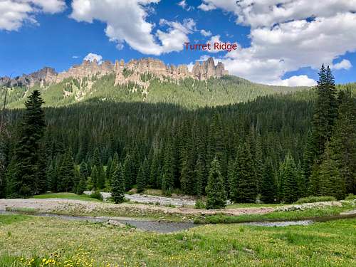
Turret Ridge is surrounded by beautiful peaks of the Cimarron Range of San Juan Mountains. You can hike and climb other peaks in the area on your trip there. For technically inclined, consider very scenic Chimney Rock, for 13er baggers: Fortress Peak, Redcliff and Coxcomb.
Colorado Rank: 1165
Line Parent: Dunsiname Mountain
Guide to Colorado Mountain with Robert Ormes (sort of a bible for Colorado mountains) provides a brief description: "Peak 12,260' is the high point of an impossible looking group of spires called Turret Ridge. The first ascent was in 1979 by a group from Iowa Mountaineers. It rivals Lizard Head as the state's hardest summit to reach. Scramble up the prominent west facing gulley beneath the highest spire. Three pitches lead up the obvious chimney system. The second and crux pitch is described as poorly protected 5.8".
Getting There
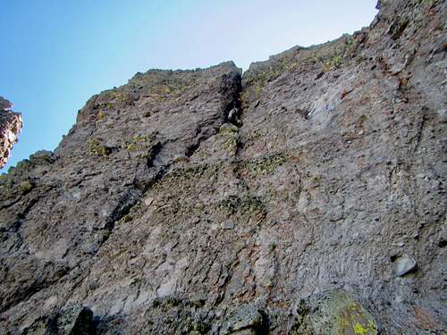
The best way to reach the Turret Ridge is to drive to the West Fork of the Cimarron. The West Fork is a good dirt road accessible by most vehicles. From US Hwy 550 turn onto CR 10 and continue towards Owl Creek Pass. 0.3 miles east of Owl Creek Pass turn on well signed road for West Fork of the Cimarron. Drive about 0.9 miles to the dirt road leading to the river. Park here. There is a nice campsite by the river.Detailed instructions: SP site here. ![The Crux Pitch]() The Crux PitchThe route described below uses my own experience, Mountain Project and List of John.
The Crux PitchThe route described below uses my own experience, Mountain Project and List of John.
![The Lichen Traverse]() The Lichen Traverse
The Lichen Traverse
Route
 The Crux Pitch
Approach Hike: Cross the West Fork for Cimarron and continue on the road closed to traffic as high as you can. Expect to wade through cold water up to mid calves, trekking poles may be useful. Follow the road until it changes into a single track and finally disappears, at this point try to head out to the Dunsiname - Turret saddle using animal trails and path of least resistance. You will have to negotiate some fallen trees, but not too bad as long as you stay southwest of the peak. From the saddle contour below the steep cliffs of Turret's - there is a sort of an animal trail there. Pass the first gully system and head for the second gully system - this is where the climb begins. The gully faces NW. There is a small platform where you can gear up, and leave trekking poles, larger back packs.
Pitch 0: Follow the gully up on some 4th class terrain, then turn right on a short but steep wall with solid holds - 5.2. Climbing eases and soon you will reach a slung rock with a rappel ring. We soloed this on both of our climbs of Turret Ridge and it felt comfortable. If you decide to lead it, there is not really protection until you reach the slung rock and although the rock is solid in steep places, there is plenty of loose rock on easier terrain. This section can retain snow till mid July.
Pitch 1: Mostly 4th class with some 5th class moves, grassy ledges, loose rock. Again, we free soloed this both times we went up. Gully is pretty wide here and many options of going up exist, try to find a path of least resistance, and not to kick rocks onto your partner. Stop at a 2 bolt belay station to the right of the chimney.
Pitch 2: Climbing starts here. Traverse left into an obvious chimney. This is rated as 5.7, and felt relatively safe. The rock was more solid in steeper sections and cobbles were holding. Stem around a large chockstone (crux), exposure here. There is a second chockstone bulge and above it escape to the right to a bolted belay stance. ~ 40 meters
Pitch 3: 4th to 5th class grass to a large slung boulder. This pitch is short and can be difficult is grass is wet.
Pitch 4: 5.8/5.9 (5.9 section is short) - start an ascending traverse to reach an obvious crack. The entry into the crack seemed tricky since the rock in this section was fragile, technically not that difficult, but frightening due to a poor rock quality. Once inside the crack, the climbing gets easier until the overhang. Take a nice rest here and then pull through it. The rock is better here and there are good handholds. This was the only place I really felt I had to pull with my arms. The crack above the overhang continues to a small ledge with a single bolt. Belay here. ~ 40 meters
Pitch 5: The Lichen Traverse: 5.6. Carefully step over the crack you came up and descent a couple of feet onto the traverse. The rock/cobbles are slightly less covered with lichen here. Make sure your handholds are rocks and not the lichen! There is some questionable protection available, mostly small to medium sized gear. Carefully move across and after about 15 meters step up (exposed) to reach a large gully leading to the summit. There are 3 pitons there. We belayed from here since the rope drag would be bad if going all the way to the summit.
Pitch 6: 4th class gully leading to the summit. Note the large pillar with several slings and rappel ring on your way up. I recommend going up roped up since the fall here would be fatal. Enjoy the summit! and look through the summit register, interesting history and truly not a frequently reached peak.
Descent: Carefully descent (very exposed) to the base of the large pillar with slings and belay rings (very obvious pillar). Re-check the condition of slings since some are historic. Again, consider roping up for this descent.
Rappel 1: Double rope rappel of 50 meters to reach the slung boulder (start of Pitch 4). The last section of this rappel is free air.
Rappel 2: Double rope rappel to reach the bolted anchors below the chimney pitch - pitch 2.
Rappel 3: Double rope rappel on easier (4th and 5th class terrain) to reach the slung rock. 1st time we rappelled this, but when we were pulling the ropes down my partner got hit in his face with a rock and suffered a minor facial injury. 2nd time we down climbed this section that felt better.
Rappel 4: Single rope rappel from the slung rock to the approach.
GEAR: 2 sixty meter ropes, camalots: 1 set from 0.3 to #4, consider #5. We had to doubles of 0.4, 0.5, 0.75 and 1. This felt like plenty of gear (2nd time we did not bring # 5). Extra webbing. Long slings.
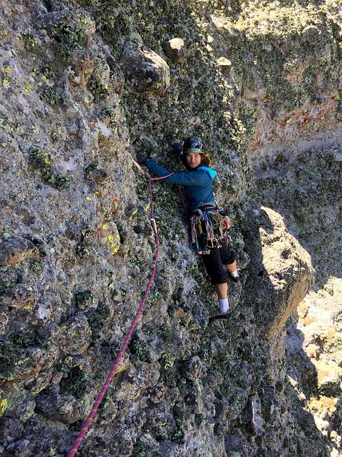 The Lichen Traverse
Red Tape
Camping, climbing, parking is free. The climb is cold! even on the hottest day. You will be in high altitude and in the shade. The peak is located in Uncompahgre National Forest.When to Climb
The climb is north facing and expect snow in the north gully up to mid July. The climb is also very cold, dress accordingly. I would recommend mid July to October. Start early to avoid afternoon thunderstorms.Camping
There are plentiful primitive beautiful camping spots in the West Fork of the Cimmaron (the whole valley below Turret Ridge). This area is popular with locals for camping and expect the best spots to be taken on summer weekends.External Links