
|
|
Mountain/Rock |
|---|---|
|
|
38.08010°N / 107.5335°W |
|
|
Hinsdale & Ouray |
|
|
Hiking, Trad Climbing, Scrambling |
|
|
Spring, Summer, Fall |
|
|
13656 ft / 4162 m |
|
|
Overview
")
Within Colorado there is a clear distinction between the fourteeners and thirteeners. Other than the obvious , height, there are NO technical fourteeners in Colorado (unlike California). There are however, multiple technical thirteeners: Lizard Head Peak, Teakettle Peak, The Index, Peak 15 and of course, Coxcomb Peak to name but a few.
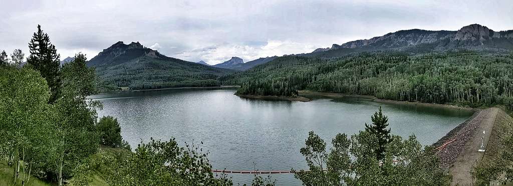
This moderately technical peak is located in the sub-range of the San Juan Mountains called, The Cimarrons. The Cimarron Range is a wildly spectacular place. The rock, being mainly volcanic is intense red at sunset. In the autumn, this contrasts nicely with the yellows and oranges of the aspen forests down below in the valley, around Silver Jack Reservoir and up on Owl Creek Pass.
The Cimarrons also hold two other distinctions. The old John Wayne film, 'True Grit' was filmed there, the easily recognizable summit of Chimney Rock in the background. The other distinction being, the states hardest twelve thousand foot (12,000') peak is located here, Turret Ridge- a scrappy lichen-covered mess that runs around 5.9.
Because of how Coxcomb Peak presents itself from the lower valleys, it resembles a cock's comb found on a rooster. It was first climbed (unsuccessfully) on August 14th, 1929 by Forrest Greenfield and Dwight Lavender. They made it to within a few meters of the true summit before being stopped by a sizeable gash in the summit ridge. Not having a rope with them (and obviously not expecting the gash), they had to abandon their summit bid. Two days later, a group of eight individuals (CMC members) led by Henry Butchel were able to successfully repel into the notch, leaving the rope behind for the short climb out, thus claiming the first true summit.
Due to its' relitively easy technical pitches, it is frequently used as a graduating climb by the BMS (Basic Mountaineering School) for the Colorado Mountain Club.
At 13,656', it is considered a bi-centennial peak (top-200 highest) and is typically highly sought after. It is located on the borders of Hinsdale and Ouray counties within the Wetterhorn quadrangle. Coxcomb Peak maintains 796' of prominance.
Getting There
- From Gunnison: Head west on highway 50 for 42 miles driving past Blue Mesa Reservoir. Around mile 41, start looking to the left (south side) for Big Cimarron Road. You'll drive past Little Cimarron Road and the Pleasant Valley RV Park, both on the left. If you end up driving to the little town of Cimarron and Newberry's Market, you've gone too far. So as you pass the RV Park, slow down a bit. It can be easy to miss. Turn left onto the good dirt road and follow south for 24.4 miles. You'll pass a few ranches and side roads. Pass Beaver Lake at mile 15.5. Cimarron Road will eventually turn into county road #858. Continue south passing Silver Jack Reservoir & campground at mile 16.8
![]() . At the East Fork junction (19.6 miles), take the right fork for .1 mile (#861) crossing a single lane bridge. Turn left onto Middle Fork (mile 19.7) and follow south to the end of the road, mile 24.4. This is the Middle Fork Trailhead (10,014') and your starting point. Take note, if it has been raining or the road is wet, it can be very slick/slippery.
. At the East Fork junction (19.6 miles), take the right fork for .1 mile (#861) crossing a single lane bridge. Turn left onto Middle Fork (mile 19.7) and follow south to the end of the road, mile 24.4. This is the Middle Fork Trailhead (10,014') and your starting point. Take note, if it has been raining or the road is wet, it can be very slick/slippery.

- From Montrose: Drive east on highway 50 for 22.1 miles to Cimarron Road. In doing so, you'll crest Cerro Summit and Cerro Recreation Area located there. Turn right (south) and follow the directions as expalined above.
- From Ridgway: This approach is only 28.7 miles, the shortest of these three options. But because of the sineous nature of the road and having to crest Owl Creek Pass and detour around Turret Ridge, this option will take you in the neighborhood of 90 minutes. Although, it is by far the most scenic approach of the three. Head north out of Ridgway on hwy. #550 for 1.8 miles. Turn right (east) onto county road #10 (Owl Creek Pass Road). Follow this dirt road to the intersection with county road #8. Turn right onto #8 and continue east to Owl Creek Pass. There will be a few side roads en route, but stay on #8 until you crest the pass. Turn left (north) onto #860 and follow this around and to the north of Turret Ridge until it comes to #861. Turn right onto #861 and follow to the roads end at Middle Fork Trailhead.
Red Tape
There isn't much red tape to speak of concerning Coxcomb Peak. Middle Fork Trailhead is located in an easement of the Uncompaghre National Forest. So dispersed camping is allowed. The peak itself and the surrounding terrain lies in Wilderness Area. So the rules in the area are a bit more strigent concerning motorized travel & camping and such. At the trailhead, motorized travel is of course, permitted and there are OHV roads in the area. Just use good judgment in regards to that. Remember to keep dispersed campsites at least 300' away from routes and trails and go easy on cross-country terrain.
Overnight camping is not allowed in day-use only areas.
|
Ouray Ranger District 2505 S. Townsend Avenue Montrose, Colorado 81401 (970) 240-5300 www.fs.fed.us/r2/gmug |
Grand Mesa, Uncompahgre & Gunnison National District 2250 S. Main Street Delta, Colorado 81416 (970) 874-6600 |
Route-Pitches
As said, Coxcomb Peak is a short but easy to moderate climb. The technical pitches are split by an easy but exposed summit ridge walk. Access the climbing on the southwest face. A single 60m rope is sufficient.
Pitch 1: Scramble up to the base of the southwest face on talus and scree. Look for a large boulder (should be about 1/2 way across or roughly in the center of the face). This boulder marks the start of a 4th class chimney. Scramble up this to the technical portion. The chimney is rated 5.2 with average holds. Climb about 80' to the summit ridge. The climbing, even for 5.2 is not at all hard. TAKE YOUR ROPE WITH YOU. You'll need it for pitch 2. Walk east along the exposed summit ridge to a prominant notch.
Pitch 2: At the notch, set up a rappel and rap down 30' into the notch. Leave the rope behind. The summit is a few minutes away on class 3+/4th rock. Climb back out of the notch on 5.6 rock. Leaving the rope behind affords you a top-rope if you didn't want to simply climb up and out. There is a good rock at the top to sling.
Protection: Just take a light alpine rack. Don't bother taking multiples, not necessary. If you feel better doing so, double up on .5 and .75. Extra webbing/slings might be a good idea if you have to back up the anchors.
 |
 |
 |
Camping
Of course Coxcomb Peak can be easily day climbed. But considering the relitive solitude and scenery of the Cimarrons, and that several options exist for camping at the trailhead and local environs, consider an overnight stay to truely enjoy the forest and wilderness.
- Silver Jack Campground: This is the largest campground in the area with 60 available sites. It is also the only campground that has water. There are several pit toilets and the nightly camping fee is only $14.00. The day-use only fee is $4.00. Because of the isolation of the reservoir and the whole area, there's no towns within easy proximity, the useage of all camping areas here is generally light. They see more use in the fall when it's hunting season. This area has three loops sprinkled with camping sites and operates on a first come basis.
- Beaver Lake: Located just north (a few miles) of Silver Jack Campground is Beaver Lake. This is a popular spot for fishermen. Fees here are a bit cheaper in that they are $12.00/night. Day use fees are the same at $4.00. There is no water but pit toilets are available. There are 11 camping sites here and it also functions on a first come basis. This area tends to be a bit quieter than SIlver Lake.
There is also dispersed camping located at the actual Middle Fork Trailhead (10,014'). Picnic tables and sites are there. About three miles up the trail, there are a few primitive camping spots in the meadow and at the boundary of the forest.
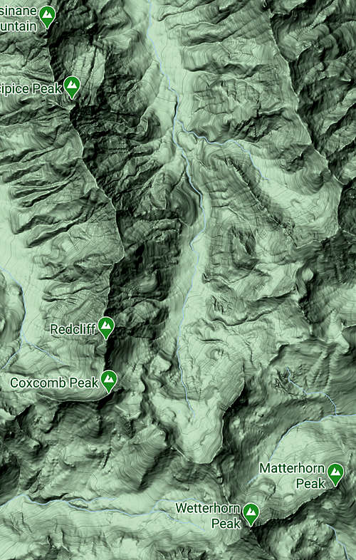
Topographic Map
 |
Extraneous Reports
- Cimarron Summits
- Mountain Project
- Airy Summits in the Middle Cimarron
- Stuck in the Rockies
- Exploring the Rockies
- USDA Forest Service
John Prater - Jul 22, 2004 2:12 pm - Hasn't voted
Untitled CommentI climbed the North Face of Coxcomb over Memorial Day weekend of 2000. We went to the Redcliff/Coxcomb saddle (climbed Redcliff first), then climbed talus up to the cliff band of Coxcomb. We roped up and climbed the obvious weakness in the cliff band. You're climbing on red rock in somewhat of a right-facing dihedral here, and I recall the crux being climbing left out of the dihedral at the top. This places you on loose, sloping class 2/3 terrain briefly. Above, I continued up a chimney (4th to low 5th class?) and belayed where the chimney turns to the right. This pitch might have been close to 50m. A short second pitch up the chimney (4th to low 5th class) dumped us out right at the summit cairn.
The excitement came on the descent. I placed a sling right below the summit and rapped down the chimney. I searched for a while for another anchor before spotting some slings up and left of the chimney. We had to ascend a bit of snow to reach those slings. A second rap from those slings placed me on the class 2/3 loose crap. Finding a suitable rap anchor here was difficult. I finally draped a sling over a solid boulder with barely a lip on the back side, and we carefully rapped off that. Yikes! This was way sketchy, from my point of view anyway.
Note that we had a single 50m rope on this trip. The route we took avoided any snow (for the most part). There was a bit of ice in the chimney, but it was avoidable by stemming.
I climbed Coxcomb again 3 weeks ago. We went up the standard southwest chimney route this time, but we planned to descend the North Face so we could more easily combine it with Redcliff. We packed two 60m ropes to avoid the "sketchy" rap. The first rap anchor I had placed 4 years ago was still there and had been backed up with another sling. However, we managed to downclimb east-northeast (?) from the summit over 3rd to 4th class terrain to reach our second rap anchor from 2000. From here, we did one 60m rappel to the bottom of the cliff band (ie, to hiking terrain). I checked out the "sketchy" rap anchor I had used in 2000, and about 4 or 5 slings had been added to it! I guess the route has seen a bit of traffic since I was up there. My recommendation is to take two 60m ropes if you plan to descend the north face. I'm not sure if two 50m ropes would reach.
peakwolf - Nov 13, 2004 4:49 pm - Hasn't voted
Untitled CommentMorgan sorry I didn't get to you in time. The trail is #226 and the approach I described is from the north, heading south to Coxcomb. The trail is named on the Trails Illustrated map as Wetterhorn Basin trail. If the map is wrong please let me know and I will change it. You do hike in along Cimarron creek.
mpbro - Jul 21, 2004 8:05 pm - Hasn't voted
Untitled CommentIf I understand you correctly, you are talking about the trailhead near the headwaters of the West Fork of the Cimarron River. I believe this trailhead is named "West Fork Cimarron", and not "Wetterhorn Basin". I was confused, because I thought you were describing the approach from the south, through Wetterhorn Basin proper. If I'm wrong about this, please let me know!
-MOrgan
mpbro - Jul 21, 2004 8:56 pm - Hasn't voted
Untitled CommentJacobs and Ormes, in Guide to the Colorado Mountains (tenth edition) describe the North Face route as follows: "At about 11,400', leave the West Fork Trail and hike up the small drainage coming off the north face. Alternating bands of snow, and a couple pitches of 5.2 rock, lead up just east of the summit, for a short scramble to the top."
This looks like an excellent alternative to the SW Chimney, especially for day trips. Anyone have additional info? Seems that much of the snow could be avoided by going to the Redcliff/Coxcomb saddle, but perhaps the snow is considered part of the route's fun?