
-
 3133 Hits
-
 81.18% Score
-
 13 Votes
|
|
Mountain/Rock |
|---|---|
|
|
39.05540°N / 105.526°W |
|
|
Park |
|
|
Hiking |
|
|
Spring, Summer, Fall, Winter |
|
|
11053 ft / 3369 m |
|
|
Overview
 UN 11053 summit
Rising just above 11,000 feet in the Puma Hills above Hwy 24, UN 11053 is a cool little companion peak to nearby prominence peak Badger Mountain. The peak is highly accessible, close to Badger Mountain road, and provides a nice side-trip just to the northwest of its larger neighbor.
The rocky summit area has quite a few trees limiting views, but between breaks in the Limber Pine bows the summit visitor can take in views of the Sawatch Range, with Mount Princeton as a fine centerpiece, as well as the highcountry peaks of the Mosquito Range, particularly the graceful Mount Silverheels.
Rank: 1757th highest peak in Colorado
Prominence: 313 feet
USGS Quad: Glentivar
Rank and Prominence Source: Lists of John
Getting There
 Limited views from summit
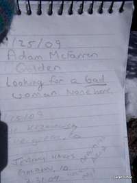 Strange register entry
UN 11053 sits about 40 miles as the crow flies north-northwest of Colorado Springs. US Hwy 24 is the main road providing access to UN 11053. Two primary routes are used by the majority of visitors to access the summit:
Direct from Hwy 24
From near the Wilkerson Pass visitors center, some opt for a very steep, timbered bushwhack/game-trail route up the southwest slopes of the peak.
I encourage anyone who has summited UN 11053 using this route to attach route information to this mountain page! For more information on this approach, read DHatfield's 14ers.com trip report.
Badger Mountain Road
A longer option that offers a very gradual ascent is to follow the Badger Mountain Road from La Salle Pass. Visit the Badger Mountain Road Route page for more details.
Red Tape
 Mount Silverheels from UN 11053
There is little red tape governing recreational use in this part of the Pike National Forest and there is no fee to access this area. Adhere to LNT (Leave No Trace) principals, observe fire ban when in effect and do not harass wildlife or allow your pet to do so.
Inclusion of several Puma Hills peaks in The Lost Creek Wilderness by Jennifer Roach and Gerry Roach has led many hikers to mistakenly draw the conclusion many of these peaks are protected within the Lost Creek Wilderness boundary. UN 11053 is not part of the wilderness, and does not enjoy wilderness protection. In fact, Badger Mountain Road cuts directly across its northeastern slopes, disqualifying much of the mountain for wilderness designation.
Camping
 Southeast from the summit
 Puma Hills Views
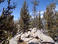 Approaching the summit
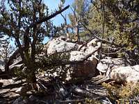 Summit area boulders
Rustic Camping
There is plenty of rustic 4x4 camping in and around the La Salle pass area, available on a first come, first served basis. Haul your own water, pack out your trash and take care of food and human waste.
Designated National Forest Service Sites
The National Forest Service has a large selection of campgrounds in and around the Lake George area.
| Campground Name | Elevation | Sites | Nightly Rate | Reservations? | Notes |
|---|---|---|---|---|---|
| Blue Mountain | 8,200 ft. | 21 | $12 | Yes | Less than 3 miles as the crow flies from the summit of Blue Mountain near Lake George. |
| Spruce Grove | 8,600 ft. | 27 | $12 | No | Let the gurgling Tarryall Creek sing you to sleep. |
| Twin Eagles | 8,600 ft. | 9 | $8 | No | Must haul or purify drinking water. |
| Happy Meadows | 7,900 ft. | 8 | $12 | No | Situated along the South Platte River. |
| Round Mountain | 8,500 ft. | 16 | $12 | Yes | Drinking water, vault toilet and trash pickup. |
| Springer Gulch | 8,300 ft. | 15 | $12 | Yes | Situated within the Elevenmile Canyon; water, tables, fire grates. |
| Riverside | 8,000 ft. | 19 | $12 | Yes | Situated within Elevenmile Canyon; large grassy meadow with little shade. |
Weather & Seasons
 Sawatch Views
 | In the summer, Badger Mountain Road will likely be busy with 4x4 and ATV traffic, thanks to the service road running to the summit from La Salle Pass. In the winter or early spring, this road could provide a smooth, white carpet perfect for a relaxed cross-country ski or snowshoe romp. Fall will bring cooler temperatures and more slender crowds, plus the added bonus of bright golden aspen. |  |