-
 18327 Hits
-
 80.72% Score
-
 13 Votes
|
|
Mountain/Rock |
|---|---|
|
|
39.78540°N / 106.0772°W |
|
|
Download GPX » View Route on Map |
|
|
Grand |
|
|
Hiking, Mountaineering |
|
|
Spring, Summer, Fall, Winter |
|
|
12303 ft / 3750 m |
|
|
Overview
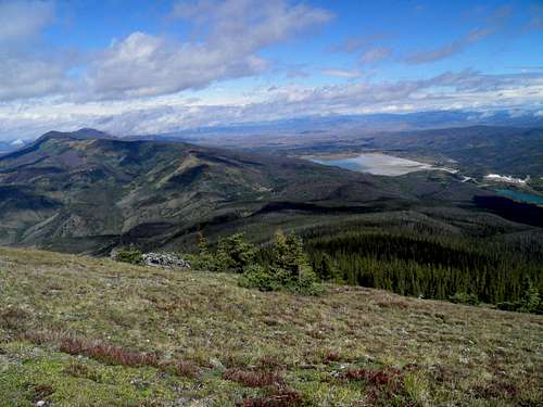
Ute Peak from the false...
Prominence: 1123 feet
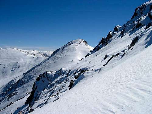
Ute Peak lies in the Williams Fork Mountains of Colorado. It is the 3Rd highest peak in the range. Great views from the summit can be enjoyed in all directions. Many reservoirs can be seen from the summit. Ute Peak offers some of the best views of the Gore Range to the west as well as the Blue River Valley. Ute Peak also, due to its elevation being 12,303' offers a lot of solitude and little traffic.
There are three routes you can take to gain the summit. The most popular being from Ute Pass. Other routes include the Acorn Trail and off of CR30 near the Henderson mine east of the summit.
 |
 |
 |
Getting There
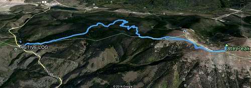
From I-70 take exit 205 North at Silverthorne. Drive approximately 12.5 miles and turn right (East) on Ute Pass Road. Drive approximately 5 miles until you reach the summit of Ute Pass. Park here.Coordinates for parking: 39.82285° N 106.10552° W
There is no red tape to hike Ute Peak!
 |
 |
|
Route
From Ute Pass head over to the signs and head south into the forest on the Ute Pass Trail. There will be a sign for the "Ute Pass Trailhead." You will be hiking through the forest until you get above treeline. Not far along the trail you will have to turn right at an intersection. There is a tree with an arrow to point this out. You will continue to climb up to about 10,200+ feet.You will then drop below 10,000 feet before gaining elevation again. About 2.5 miles from the start you will hit a T-intersection. Turn right. This is where the elevation gain really starts. You will have about 2,400 feet of elevation to gain over the last ~3.2 miles to the summit. Most of this is over the next 1.5 miles.
At about ~11,600 feet you will come above treeline and the trail gets faint. Head straight west up to the ridge. You will find another trail. Take the trail to the south. Soon Peak 12254 comes into view. This is not the true summit. Continue on the trail. Ute Peak will soon come into view to the south. Follow the trail around point 12254 and then over to Ute Peak.
Trailhead elevation: ~9580'
Trailhead elevation: ~9580'
Summit Elevation: 12,303'
Round trip Distance: Approx 11.4 miles
Net Elevation Gain: Approx 2,730 ft
Net Elevation Gain: Approx 2,730 ft
Total Elevation Gain: Approx 3,000 ft
 |
 |
|
 |
 |
 |
 |
 |
When to Climb
Ute Peak can be climbed year round. During the snow season it will definitely be a snowshoe.Camping & Red Tape
There is no red tape to hike Ute Peak!
CAMPING
White River National Forest
Directions: From I-70 take Exit 205. Travel north on HWY 9 for approximately 6 miles. The campground is on the right side of the highway. It is called Blue River Campground.
Reservations: First-Come, First-Serve
Open Season: Memorial Day - Labor Day
Water: None
Restroom: Vault Toilets
 |
|
 |
 |
External Links
- Denver Post Article of Ute Peak
- Panorama from Ute Peak
- Acorn Creek Trail
- Someone's trip from Acorn Creek to Ute Peak
Weather