
-
 26988 Hits
-
 87.49% Score
-
 25 Votes
|
|
Area/Range |
|---|---|
|
|
39.49400°N / 106.635°W |
|
|
12757 ft / 3888 m |
|
|
Williams Fork Mountains Overview
 The Williams Fork Mountains are a small sub-range of Colorado's expansive Front Range. Of the two named "Williams Fork Mountains" this is the group that clusters between the Blue River and the Williams Fork of the Colorado River of Summit County. The other range bearing this name is found in Moffat County on the Williams Fork of the Yampa. They extend from near the Eisenhower Tunnel (north of I-70) west for six miles to Ptarmigan Peak. At Ptarmigan Peak the range suddenly turns north and continues for twenty five miles. The two main ridges of this range contain 12,757 foot Coon Hill, 12,498 foot Ptarmigan Peak, and 12,303 foot Ute Peak. The range is delineated from the adjacent Vasquez Mountains to the east by the dark and heavily forested Williams Fork River drainage. I-70 marks the southern boundary of the range. To the west the mighty Blue River separates the Williams Fork Mountains from the superbly ragged Gore Range. Looking at the Gores across this river valley is one of the attractions of spending time on these summits.
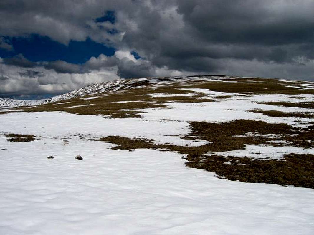
The Williams fork mountains are generally quiet gentle (excepting a small area near Coon Hill). Consisting of rolling ridgelines of alpine tundra these mountains can be strolled across. The broad swaths of tundra would likely teem with alpine wildflowers in the summer months. This gentle countenance also makes them ideal mountains during the snowier months of the year.
The surrounding civilization composed of I-70, the town of Silverthorne, and Highway 9 running along the blue river also color the experience on these mountains. As a positive effect they provide easy access and close amenities. The negative effect is that the wilderness experience is different than in a more remote region.
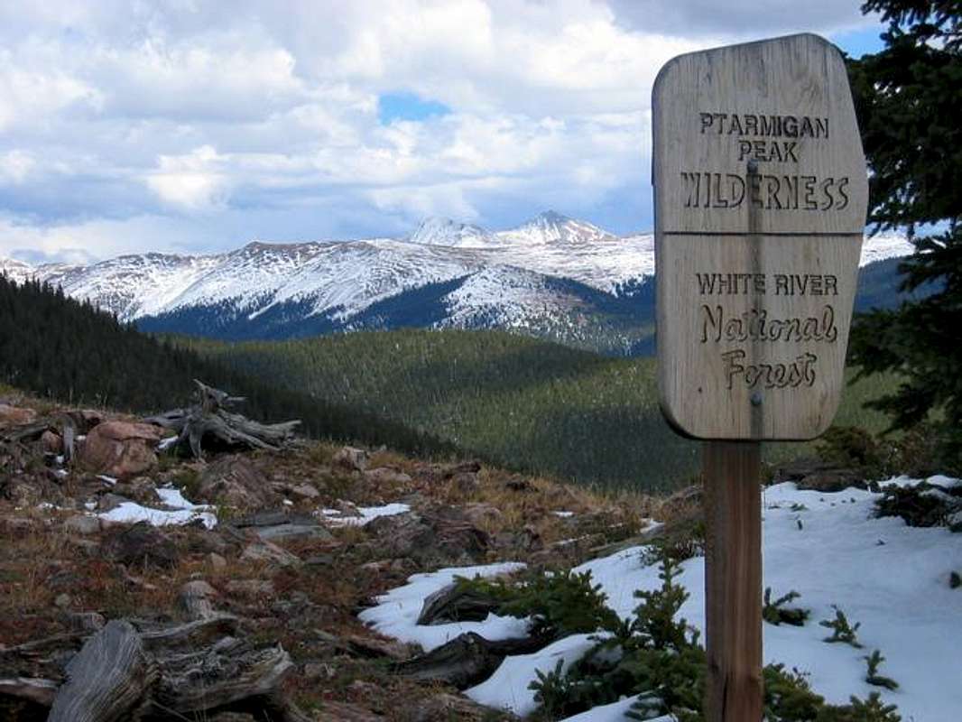
A small portion of the Williams Fork Mountains have been protected as the 13,175 acre Ptarmigan Peak Wilderness. Designated a wilderness area in 1993 the final outcome was far short of the 54,000 acres originally proposed. This is largely due to the role the east flanks of the Williams Fork Mountains have in quenching the city of Denver's thist for water. The Williams Fork Watershed is used by the city of Denver to trade water to Western Slope senior water rights holders when it diverts more water then permitted from other watersheds. Thus the 96,822 acre Williams Fork Watershed allows Denver to provide for Denver's denizens when times are dry. Please see this Denver Water link for more information. Denver Water fought hard to keep the protected status from interfering with the diversion project or possible future expansions of it. As such the Ptarmigan Peak Wilderness actually exists from timberline near Coon Hill to the range crest on only the south facing or west facing slopes. The summits are on the edge of the protected area and the timbered areas are completely excluded. It is a curious configuration.
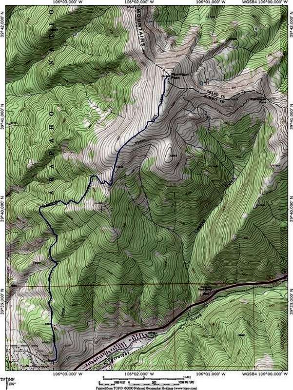
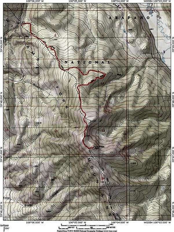
The Williams Fork Mountains are accessed by three rather good trails. The Ute Peak Trail extends from Ute Pass south for twelve miles before meeting up with the Ptarmigan Peak Trail. This trail offers a chance to traverse a sizable section of the range and experience miles of tundra walking and expansive views. The Ptarmigan Peak Trail originates just above Silverthorne and wanders 5.3 miles to the summit of Ptarmigan Peak. The South Fork Trail extends south up the South Fork of the Williams Fork River for 5 miles, meeting up with the Ptarmigan Peak trail at Ptarmigan Pass. This trail system despite its small size offers many options for experiencing the Williams Fork Mountains.
Ptarmagin Peak Overview (12,498 ft.)
Ptarmigan Peak is a reclining ridge of a mountain rising above the town of Silverthorne. It is easily accessed from Silverthorne via the excellent Ptarmigan Peak Trail. The rolling nature of Ptarmigan Peak combined with deep snow would make this an ideal mountain for a ski ascent. Avalanche danger would be minimal. This mountain is deffinately popular with locals and during the summer and fall months you will likely run into other hikers.
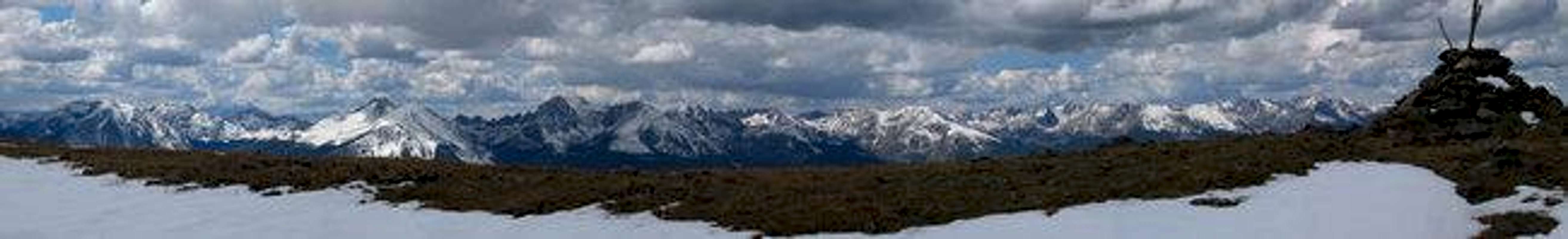
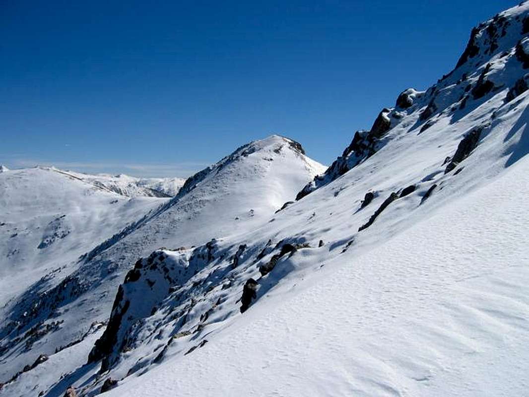
The primary distinction of Ptarmigan Peak is its intimate view of the Gore Range located right across the Blue River valley. For the pedestrian ascent one is rewarded by vertigo inducing views of Buffalo Mountain, Red Peak, and the Willow Peak Massif. From a grassy perch amidst rolling tundra one of Colorado roughest ranges can be closely examined. And just to the south one can view the white sails of boats bobbing far below on Lake Dillon. The juxtaposition of these diverse visual elements makes this a worthwhile ascent.
Ute Peak Overview (12,303 ft.)
Ute Peak is the hidden gem of the Williams Fork Mountains. It is the northern highpoint rising just south of Ute Pass. It is a far more obscure summit then Ptarmigan Peak and it offers a much more satisfying wilderness experience. The timbered area near Ute Peak has been heavily hit by the Pine Beatle blight and many dead trees are in the area. For this reason deadfall can be a danger... Stay on the Ute Peak Trail and avoid bushwhacking (the author can attest stepping over endless downed trees in postholing snow conditions is not a pleasant way to travel in this area). There are meadows along the Ute Peak Trail that would offer pleasant camping.
Above timberline expansive views are to be had. As on Ptarmigan Peak the Gore Range is the obvious highlight. However it quickly becomes apparent the Ute Peak itself has some enticing characteristics of its own. The range in this region is moderately cirqued on the east side resulting in drop-offs not encountered to the south. The summit pyramid itself is a scruffy little thing that gives the mountain a distinct highpoint.
The views from the top allow one to peer into Middle Park to the north. The Front Range is visible in the distance to the east. Closer the Byers Peak Massif rises across the Williams Fork drainage. To the South the gentle ridge-crest of the Williams Fork Mountains extend to the rotund Ptarmigan Peak. Directly west the main section of the Gore Range rises like a deeply serrated jaw of some great beast. From north to south extends a most impressive line of summits:Eagles Nest Peak, Mount Powell, Peak C, Peak E, Peak F, Peak G, and Keller Mountain. Such a panorama results in Ute Peak having some of the best views in the state.
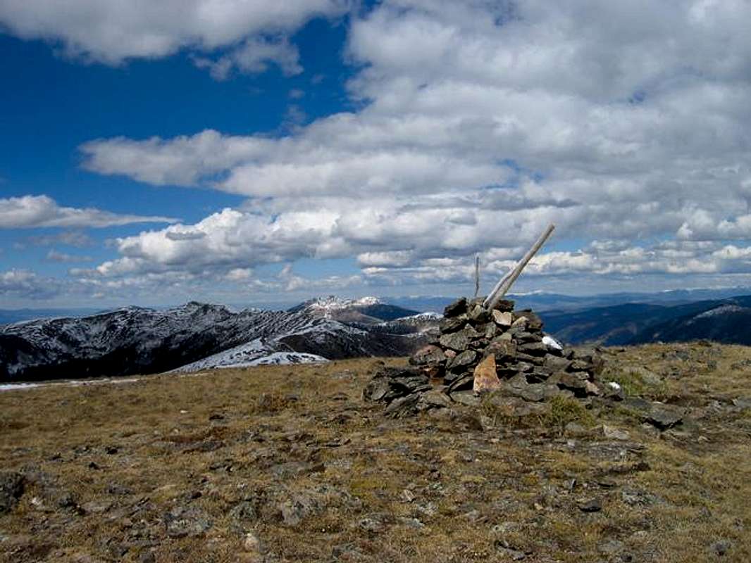
Coon Hill Overview (12,757 ft.)
Coon Hill is the highpoint of the Williams Fork Mountains. It rises just north of the western entrance to the Eisenhower Tunnel. The traditional access from the parking lot located at the tunnels western entrance has been closed by the Colorado Department of Transportation due to terrorism concerns. As such I plan on attempting an ascent via either the Loveland Ski Area or the Williams Fork Drainage. More information will be added after a new route is found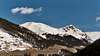 |
Red Tape
The Ptarmigan Peak Wilderness is in the Dillon Ranger district. Please use the contact listed below for more information.Dillon Ranger District
680 River Parkway
Silverthorne, CO 80498
970-468-5400
Wilderness regulations apply within the wilderness boundary.
When To Climb
The Williams Fork Mountains could be ascended year round. The summer would provide the opportunity to walk along broad swaths of alpine tundra replete with wildflowers. However the Williams Fork Mountains are great off season or shoulder season mountains. The nearby paved highways allows year round access. The upper slopes are gentle enough to mitigate avalanche danger when snow drapes the ground. In the Fall there is a rather pleasant aspen grove that the Ptarmigan Peak Trail passes through.Camping
Camping is a possibilty. The Ptarmigan Peak Trail is to close to civilization to warrant an overnighter but the South Fork Trail and Ute Peak Trail provided small inconspicuous campsites.Mountain Conditions
For a detailed seven day forcast of the nearby town of Silverthorne, CO please click this link.
JonBradford - Nov 17, 2004 8:41 pm - Hasn't voted
Untitled CommentScott you might have just saved me a towing (I was planning on trying this route sunday)... no I did not know this but I was suspicious of the possibility. If this is the case my description of Coon Hill might have to wait until I access it via the Williams Fork drainage or Loveland Ski Area. Oh well. Thanks again.
Jon Bradford
Scott - Nov 19, 2004 11:30 am - Voted 10/10
Untitled CommentHi Jimmy, apparently the route was closed since the tunnel is now on the list for potential terrorist targets. CDOT now stores alot of explosives at the lot, they don't want people parking and poking around, and say they will tow cars. I don't know if this is just temporary or permanent. I assume it may be permanent, but I'm not sure.
Scott - Nov 17, 2004 8:28 pm - Voted 10/10
Untitled CommentHi, Jon.
I have some bad news about Coon Hill which you may or may not be aware of. Recently CDOT has banned parking along I-70 in the west side of the tunnel. The access road near the west entrance that heads north is also closed to both vehicles and walking. Apparently it is part of the CDOT right-of-way and they will tow any cars parked in the area, and people walking on the road will be reported.
I just wanted to let you know of the situation. If you all ready knew this, I apologize. Feel free to delete this message after you read it
Scott
JonBradford - Nov 17, 2004 8:41 pm - Hasn't voted
Untitled CommentScott you might have just saved me a towing (I was planning on trying this route sunday)... no I did not know this but I was suspicious of the possibility. If this is the case my description of Coon Hill might have to wait until I access it via the Williams Fork drainage or Loveland Ski Area. Oh well. Thanks again.
Jon Bradford
Scott - Nov 19, 2004 11:30 am - Voted 10/10
Untitled CommentHi Jimmy, apparently the route was closed since the tunnel is now on the list for potential terrorist targets. CDOT now stores alot of explosives at the lot, they don't want people parking and poking around, and say they will tow cars. I don't know if this is just temporary or permanent. I assume it may be permanent, but I'm not sure.
Aaron Johnson - Nov 19, 2004 5:52 pm - Voted 9/10
Untitled CommentJon-
I have linked to this page from my route page for Hagar. If you incorporate this text and delete this page, please let me know! Thanks!