
-
 18535 Hits
-
 80.49% Score
-
 12 Votes
|
|
Mountain/Rock |
|---|---|
|
|
39.04900°N / 105.5126°W |
|
|
Park |
|
|
Hiking |
|
|
Spring, Summer, Fall, Winter |
|
|
11294 ft / 3442 m |
|
|
Overview
 Badger Mountain from the west
Badger Mountain is a prominent Elevener at the heart of the Puma Hills, just north of Wilkerson Pass. Plenty of people motor right though Wilkerson Pass, cutting across the feet of Badger Mountain to the southwest, without knowing that above them rises a powerful peak with almost 1,600 feet of prominence.
Indeed, Badger Mountain could be categorized as the “strong, silent type,” and it hides its strength well under a dense blanket of trees. Heavily forested with a thicket of communications towers at the summit, the mountain itself wins no awards for pure aesthetics. The trees on top are stunted and many twisted by the winds, but none-the-less are still large and robust enough to prevent wide-open views.
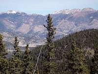
Yet from the top of this mountain, or on the way to it, the hiker can steal views of South Park and the Tarryall Mountains. Also on the summit boulder, right next to the USGS summit marker, is the…summit drawer. What looks like a battleship gray, government surplus desk drawer is affixed to the summit by a heavy chain. There was, however, no summit register present during my visit in the spring of 2011.
It is notable that per local historian Midge Harbor (Tarryall Mountains and Puma Hills A History) the mountain is named not after a stocky, scrappy, omnivorous weasel but rather after John Badger (1821-1897), a veteran of both the US Civil War as well as the Mexican-American War. His grave can be visited along Old Wilkerson Pass Road in Park County.
Additionally, old-timers speak of a fire tower on the summit of Badger Mountain in the 1950s and 1960s, though I have not found documentation or articles on the history of this structure.
Rank: 1,648th highest peak in Colorado
Prominence: 1,594 feet
USGS Quad: Glentivar
Rank & Prominence Source: Lists of John
Getting There
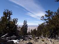 South Park views en route
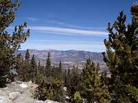 Summit views to the northwest
Badger Mountain sites about 40 miles as the crow flies north-northwest of Colorado Springs. US Hwy 24 is the main road providing access to Badger Mountain. Two primary routes are used by the majority of visitors to access the summit:
Direct from Hwy 24
From near the Wilkerson Pass visitors center, some opt for a very steep, timbered bushwhack/game-trail route up the southwest slopes of the peak.
Visit the Direct from Hwy 24 route page by Tjohn67238 for details. For more information on this approach, read DHatfield's 14ers.com trip report.
Badger Mountain Road
A longer option that offers a very gradual ascent is to follow the Badger Mountain Road from La Salle Pass. Visit the Badger Mountain Road Route page for more details.
Red Tape
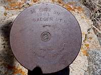 Summit area medallion Summit area medallion |  Summit drawer Summit drawer | 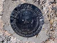 USGS Summit Marker USGS Summit Marker |
There is little red tape governing recreational use in this part of the Pike National Forest and there is no fee to access this area. Adhere to LNT (Leave No Trace) principals, observe fire ban when in effect and do not harass wildlife or allow your pet to do so. When on the summit, please stay away from all summit structures.
Inclusion of this peak in The Lost Creek Wilderness by Jennifer Roach and Gerry Roach has led many hikers to mistakenly draw the conclusion this peak is protected within the Lost Creek Wilderness boundary. It is not part of the wilderness, and does not enjoy wilderness protection. In fact, it has a road to the summit, disqualifying it for wilderness designation.
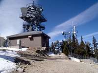 Collection of summit structures Collection of summit structures |  Summit relay tower Summit relay tower | 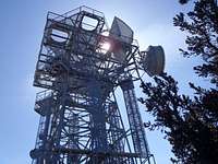 Bulky communications tower Bulky communications tower |
Camping
 Bison Peak and McCurdy Mountain from Badger Mountain
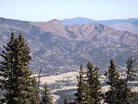 Pilot Peak from Badger Mountain
Rustic Camping
There is plenty of rustic 4x4 camping in and around the La Salle pass area, available on a first come, first served basis. Haul your own water, pack out your trash and take care of food and human waste.
Designated National Forest Service Sites
The National Forest Service has a large selection of campgrounds in and around the Lake George area.
| Campground Name | Elevation | Sites | Nightly Rate | Reservations? | Notes |
|---|---|---|---|---|---|
| Blue Mountain | 8,200 ft. | 21 | $12 | Yes | Less than 3 miles as the crow flies from the summit of Blue Mountain near Lake George. |
| Spruce Grove | 8,600 ft. | 27 | $12 | No | Let the gurgling Tarryall Creek sing you to sleep. |
| Twin Eagles | 8,600 ft. | 9 | $8 | No | Must haul or purify drinking water. |
| Happy Meadows | 7,900 ft. | 8 | $12 | No | Situated along the South Platte River. |
| Round Mountain | 8,500 ft. | 16 | $12 | Yes | Drinking water, vault toilet and trash pickup. |
| Springer Gulch | 8,300 ft. | 15 | $12 | Yes | Situated within the Elevenmile Canyon; water, tables, fire grates. |
| Riverside | 8,000 ft. | 19 | $12 | Yes | Situated within Elevenmile Canyon; large grassy meadow with little shade. |
Weather & Seasons
 | In the summer, this peak will likely be busy with 4x4 and ATV traffic, thanks to the service road running to the summit from La Salle Pass. In the winter or early spring, this road could provide a smooth, white carpet perfect for a relaxed cross-country ski or snowshoe romp. Fall will bring cooler temperatures and more slender crowds, plus the added bonus of bright golden aspen. |  |