
-
 8945 Hits
-
 79.78% Score
-
 11 Votes
|
|
Mountain/Rock |
|---|---|
|
|
39.01110°N / 105.5172°W |
|
|
Park |
|
|
Hiking |
|
|
Spring, Summer, Fall, Winter |
|
|
10538 ft / 3212 m |
|
|
Overview
 Familiar Friend: Pikes Peak from Pulver Mountain
From many angles, Pulver Mountain appears to simply be a big, green and rather uninteresting hump. Pulver Mountain holds a secret, however, and that secret is a rocky, open summit perch with southwest views wide open to the wind and the sky. This peak has no official trail to its summit (though a faint foot path from FS 706 is becoming increasingly defined). Few people outside of the peak hunter community and folks with property in the area bother to seek this summit. The result is a quiet peak with plenty of solitude, serving up close-up views of nearby Stoll Mountain and Elevenmile Reservoir, plus more distant views of the Hayman Burn, Pikes Peak and even the Sawatch Mountains.
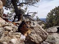
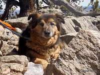
So pack a lunch, grab a dog and head up hill. Plan to spend plenty of time on the summit outcrop, soaking up sunshine, leafing through the summit register, maybe even kicking back and taking a nap.
Rank: 2021st highest peak in Colorado
Prominence: 318 feet
USGS Quad: Glentivar
Planning Map: There is no Trails Illustrated Map for this area; you will need a custom trail map for this mountain
Rank & Prominence: Lists of John
Getting There
 Summit views toward Stoll Mountain
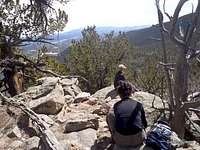 Open summit outcrop
Wilkerson Pass is roughly 1 hour (or 50 miles) west of Colorado Springs, Colorado. Pulver Mountain sits to the southeast of Wilkerson Pass and is easy to access from US Hwy 24. Most visitors to this peak will access the summit from County Road 90 south of Hwy 24.
 |  |  |
Red Tape
 Distant Sawatch Views
 Summit register
 The summit of Pulver Mountain and a vast majority of the entire mountain reside within the Pike National Forest. However, there is a lot of private property, specifically residences, to the east and northeast of the peak. Forest Roads and public land provide all the access you need to reach this summit. Please respect private property, do not use private drives, do not park on private land, watch your vehicle speed through residential areas and be friendly to any locals you may encounter.
Camping
 Pilot Peak from Pulver Mountain
 Northeast from Summit
The National Forest Service has a large selection of campgrounds in and around the Lake George area.
| Campground Name | Elevation | Sites | Nightly Rate | Reservations? | Notes |
|---|---|---|---|---|---|
| Blue Mountain | 8,200 ft. | 21 | $12 | Yes | Less than 3 miles as the crow flies from the summit of Blue Mountain near Lake George. |
| Spruce Grove | 8,600 ft. | 27 | $12 | No | Let the gurgling Tarryall Creek sing you to sleep. |
| Twin Eagles | 8,600 ft. | 9 | $8 | No | Must haul or purify drinking water. |
| Happy Meadows | 7,900 ft. | 8 | $12 | No | Situated along the South Platte River. |
| Round Mountain | 8,500 ft. | 16 | $12 | Yes | Drinking water, vault toilet and trash pickup. |
| Springer Gulch | 8,300 ft. | 15 | $12 | Yes | Situated within the Elevenmile Canyon; water, tables, fire grates. |
| Riverside | 8,000 ft. | 19 | $12 | Yes | Situated within Elevenmile Canyon; large grassy meadow with little shade. |
Weather & Seasons
 | In the summer, the area surrounding this peak may get a little hot and dusty, but is still unlikely to be terribly crowded. Fall will bring cooler temperatures and more slender crowds, plus the added bonus of bright golden aspen. This peak would be a delightful winter or spring snowshoe, though the roundtrip distance and overall effort would increase, and finding a safe place to park your vehicle may be a bit more of a challenge in snowseason. |  |
 Ready to roll home