

Comments
No comments posted yet.
|
|
Trip Report |
|---|---|
|
|
Download GPX » View Route on Map |
|
|
May 12, 2016 |
|
|
Hiking |
|
|
Spring |
If you do a quick search for “Grand Canyon in a Day,” you get a bunch of results suggesting you may be insane for thinking about it. Insane or not, my wife and I wanted to go all the way to the Colorado River and back when we visited the Grand Canyon.
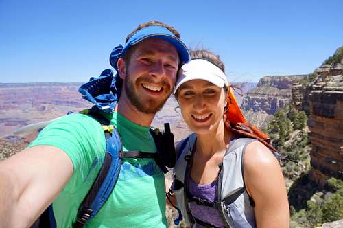
After hemming and hawing, we finally agreed to put on our tough hiker pants (or shorts) and go for it in day. The decision was not made lightly. For fitness background, my wife runs 10ish miles a day, every day of the week, regularly. Which instantly puts her in better shape than me. I’ve done other long in-a-day objectives, including: Dix Range in a day (Adirondacks), Lone Peak Cirque plus climbing in a day (Wasatch Range), Grand Teton in a day (Wyoming), and a few other long backpacks with heavy bags to the Wind Rivers, WY. Living at elevation in Salt Lake, and regularly playing in the mountains with lots of sun and low humidity definitely helped.
Without too much else to go on, apart from knowing people run rim-to-rim, we set off to make our own observations and experiences.
We did our hike May 12, 2016. The forecasted South Rim high was 74. The forecasted canyon floor high was 95. Hardly ideal, but with an early morning temperature of 34 we deemed it was a good compromise.
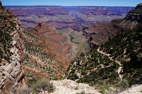
We made it to the watering hole outside of the Bright Angel campground 3 hours later. That’s 7:40AM, and the thermometer on my GPS watch read 81 degrees. Time to get moving! The 1.5 miles between Bright Angel campground and the Bright Angel Trail/Colorado River junction is mellow but comparatively boring when juxtaposed against the views and backdrop of the South Kaibab trail.
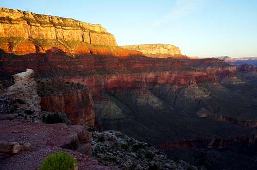
The business starts about 2 miles into the 8 mile hike up the Bright Angel trail. The start is mellow, scenic, and the stream flowing nearby adds to the serenity. Tall walls enclose you and it’s hard to tell how low you really are in the canyon. Then the switchbacks start.
The heat began to take its toll. We pulled out bandanas and tucked them into our hats to shade our necks and ears. We’d also soak them to help cool us off. We stopped to eat lunch at the Indian Garden campground at the 5 hour mark (9:40AM). An early lunch for sure but at this point we were borderline hangry and warm. Hot and bothered? Indian Garden provides a welcome reprieve with large trees for shade, water fill up, and bathrooms. After taking a significant break and having a nice chat with another couple, we continued up and up.Most sources encourage hiking up the Bright Angel trail because it has more shade than the South Kaibab trail and has water. This may be true. But at high noon, the shadows are short and the only shade comes from trees. This means the last few miles are quite exposed to the sun.
We broke down the next section into the rest house stops. These stops 1.5-1.6 miles apart are welcome, provide shade and water, and a chance to look up and wonder how the trail makes it up. They are also the longest 1.5 mile sections of trail I’ve ever done!We made it back up to the rim in just over 7.5 hours (7:40 to be precise), putting us back on the rim at 12:20PM. It was STILL warm, even all the way up there! We took the “Blue Route” shuttle back to the visitor center, then quested off to find our new campsite. We also tried to find a place in town that served milkshakes but that was a fruitless effort. Wendy’s was the best bet.
Trip stats:
17 miles
5000’ descent, 4550’ ascent (this includes the
little sections of up/down along the trail too)
5.5 liters of water consumed
Down time: 3 hours
Up time: 4.5 hours
3200 calories burned
2.3mph (average)
Fun factor: solid type 2
Suggestions: If all the water spigots are on, you can get away without a water filter. Though I’d be remiss if I didn’t tell you to bring some form of backup or water filtration. Something can always go wrong.
If seeing the Bright Angel campground is not high on your list, I’d almost recommend hiking down the Bright Angel trail, spending some time at the “beach” at the intersection with the Colorado, and then hiking back up late afternoon (4PM). However, the South Kaibab trail is significantly more scenic with better views.Warnings: the hike is not a joke. But if you’re in good shape, familiar with hot and dry desert hiking (at elevation), and avoid the heat, this is a very doable hike. If you are not prepared, then you are in for a very rough time. That being said, I would not necessarily discourage people from hiking rim-to-river-to-rim with the same adamant caution that the NPS does. (To be fair, a significant portion of the “National Park crowd” is underprepared and not in any sort of shape to attempt this hike.)
So, thinking about doing this hike for yourself? Do some test hikes in your area and compare these trip stats against your hiking history. Are they comparable? If so, you will find it a very rewarding experience.