
-
 27843 Hits
-
 87.75% Score
-
 25 Votes
|
|
Mountain/Rock |
|---|---|
|
|
45.90560°N / 6.91830°E |
|
|
11302 ft / 3445 m |
|
|
Overview
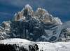
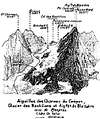
Aiguille des Grands Charmoz is an incredible pinnacle located in the Aiguilles de Chamonix. It's placed to the west of Mer de Glace, between Aiguille de la Republique (NE) and Aiguille du Grépon (S). Other near glaciers are: Glacier de la Thendia (N), Glacier de Trélaporte (E) and Glacier des Nantillons (W). The narrow crest of this peak is generally traversed, more often than not in conjunction with the Grépon. Some of the best routes in the Aiguilles de Chamonix, on both rock and ice, lie on its various flanks and ridges.FIRST CLIMB: H Dunod and P Vignon with J Desailloux, F Folliguet, F and G Simond on 9 August 1885.
First winter climb: C Sauvage with J Ravanel on 11 January 1910.
ROUTES OVERVIEW
SW FACE AND MAIN RIDGE TRAVERSE (AD+)
E PILLAR (D-)
AIGUILLE DE LA REPUBLIQUE (D-)
NE RIDGE INTEGRAL (TD-)
NW RIDGE (TD)
N FACE (TD)
BOUCHARD ROUTE (ED2)
W face
This splendid wall has many finest routes but some of them were destroyed in 1980 by the partial collapse of the central pillar. The continuity of the face is unfortunately broken at two-thirds height by a zone of easy terraces by wich it's possible to effect and escape (to the right) into the Charmoz-Grépon Couloir. There are only two independent finishes on the final wall and that taken by the Desmaison route is rarely done. The start of the routes can be reached from Plan de l'Aiguille in 1 h 30 min.
ORIGINAL ROUTE (IV+ / V)
GHILINI ROUTE (TD-)
CORDIER PILLAR (TD)
DESMAISON ROUTE (TD)
NtHE PILLAR (TD)
HAGENMULLER -BERNERON ROUTE
HAGENMULLER-MARX ROUTE (TD+)
 |  |  |  |  |
Getting There
Chamonix-Mont Blanc is the base of the mountain. It's placed between three bordiers, France, Italy and Switzerland.Airports and roads
Autoroute Blanche E25-A40 is the expressway for reaching the town. Because of the Mont Blanc Tunnel, Chamonix is near the big central europe cities (Geneva, Lyon, Turin...) All of them have international airports.
Annecy-Meythet Airport
8, route de Côte Merle
F-74370 Chamonix-Mont Blanc
Tel : +33(0)450273006
Chamonix - Geneva Airport
SAT
40, place de la gare
F-74400 Chamonix-Mont Blanc
Tel : +33(0)450530115
Geneva International Airport
Case postale 100
Geneva 15
CH-1215 Geneva 15
Tel : +4122 7177111
Lyon-Saint Exupery International Airport
F-69125
Tel : +33(0)472227221
Distance from Chamonix to the main towns of the French Alps:
Aix-Les-Bains 120 km
Albertville 67 km
Annemasse 80 km
Annecy 94 km
Bourg-Saint-Maurice 121 km
Chambéry 110 km
Courchevel 118 km
Evian 99 km
Grenoble 153 km
Megève 35 km
Thonon 80 km
Tignes 152 km
Val-d'Isère 150 km
Distance from Chamonix to the main town of France:
Bordeaux 735 km
Lyon 220 km
Besançon 257 km
Dijon 273 km
Lille 726 km
Marseille 481 km
Nantes 777 km
Nice 379 km
Paris 612 km
Rennes 809 km
Saint-Etienne 277 km
Strasbourg 478 km
Toulouse 649 km
Distance from Chamonix to the main towns of Central Europe:
Genève 85 km
Martigny 38 km
Lausanne 108 km
Bern 173 km
Bâle 269 km
Zürich 307 km
Torino 171 km
Milano 238 km
Roma 238 km
Frankfurt 595 km
München 616 km
Bruxelles 844 km
Antwerp 888 km
Train
TGV sometimes reaches the Saint-Gervais Le Fayet station, located at the entry of the valley. The trains of SNCF goes from Saint Gervais to Martigny (Switzerland).
Funicular Chamonix-Montenvers
Bus
It's free for the owners of carte d'hôte, it goes from Servoz to Le Tour.
 |
Red Tape
It could be seasonal closures because of the bad weather but there is no red tape. |  |
When To Climb
The best season is from July to August. June and September ascentes can be risky depending on the weather conditions, consult the weather forecast at Maison de la Montagne (Chamonix) before your climb. Winter ascents are posible but dangerous.Do "click" on Weather when here for the Chamonix Valley and Mont Blanc Area Weather Forecast
 |  |
Lodging
Office de Tourisme-Centrale de Reservation address: 85, place du triangle de l'Amitié - boîte postale 25F-74400 Chamonix-Mont Blanc - tel. +33 450 532 333 - fax +33 450 537 550 - reservation@chamonix.com
Hotel du Plan de L'Aiguille (2.203 m)
Private, 30 beds. Situated about 10 minutes below the Téléphérique Station. 2-3 hours from Chamonix-Mont Blanc, using the path starting opposite the Aiguille du Midi Téléphérique Station.
Montenvers Hotel (1.909 m)
Built in 1880, private (Commune de Chamonix), 12 beds.Situated just below the terminus of the funicular. Tel: +33(0)4 50 53 12 54 Chamonix 74400. 2-2 h 30 min from Chamonix or 1 h 30 min - 2 h from Le Praz.
Campings
Les Deux Glaciers ***
80, route des Tissières
Les Bossons
F-74400 Chamonix-Mont Blanc
Tel : +33(0)450531584
L'ile des Barrats***
185, chemin Ile des Barrats
F-74400 Chamonix-Mont Blanc
Tel : +33(0)450535144
I've been there, it's a good camping
Les Marmotes***
140, chemin des Doux
Les Bossons
F-74400 Chamonix-Mont Blanc
Tel : +33(0)450536124
La Mer de Glace***
200, Chemin de la Bagna
Les Praz
F-74400 Chamonix-Mont Blanc
Tel : +33(0)450536477
Les Rosieres***
121, clos des Rosières
Les Praz
F-74400 Chamonix-Mont Blanc
Tel : +33(0)450531042
Les Arolles**
281, chemin du Cry
F-74400 Chamonix-Mont Blanc
Tel : +33(0)450531430
Les Cimes**
28, Route des Tissières
Les Bossons
F-74400 Chamonix-Mont Blanc
Tel : +33(0)450535893
Les Drus**
114, chemin de la Corba
Les Bois
F-74400 Chamonix-Mont Blanc
Tel : +33(0)450534920
Les Ecureuils**
Chemin des Doux
Les Bossons
F-74400 Chamonix-Mont Blanc
Tel : +33(0)450538311
Le Glacier D'Argentiere**
161, chemin des Moillettes
F-74400 Argentiere
Tel : +33(0)450541736
Les Molliases**
Chemin à Batioret
F-74400 Chamonix-Mont Blanc
Tel : +33(0)450531681
Les Verneys**
180, route des Tissières
Les Bossons
F-74400 Chamonix-Mont Blanc
Le Gran Champ*
Derrière le Novotel
Les Bossons
F-74400 Chamonix-Mont Blanc
Tel : +33(0)450530483
Chalet Austria
A small and disused wooden hut for those requiring a "comfortable" bivouac free of charge.
Refuge d'Envers des Aiguilles (2.523 m)
CAF, 46 beds, warden, restaurant, no phone. Situated at the base of the SE ridge of the Tour Verte below Aiguille de Roc. 2 h 30 min from Montenvers. When at L'Angle continue up the right side of the glacier wich is fairly flat and waymarked. Leave the glacier at the foot of the N spur of the Tête de Trélaporte (yellow paint flashes) and climb ladders to reach a good path that traverses left below the Trélaporte glacier. Go round the SE ridge of the Aiguille de Roc and zig-zag steeply up to the hut. In winter the best method is to start from the Midi Téléphérique Station. Descend Vallée Blanche, Géant icefall... Until roughly level with the hut. Reach the moraine on the left and from its top go diagonally up right (avalanche potential; path in summer) to the hut.
 |
Mountain Conditions
Avalanches (in French) |
External Links
- Mont Blanc Massif
Links, Phonenumbers, Infos etc. concerning the whole Mont Blanc area
- mountain guide
climbing in mont blanc